Wonalancet River facts for kids
Quick facts for kids Wonalancet River |
|
|---|---|

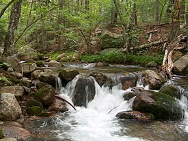
The Wonalancet River near its source in the Sandwich Range
|
|
| Country | United States |
| State | New Hampshire |
| Counties | Grafton, Carroll |
| Towns | Waterville Valley, Sandwich, Albany, Tamworth |
| Physical characteristics | |
| Main source | Sandwich Range White Mountain National Forest 2,320 ft (710 m) 42°56′34″N 71°23′38″W / 42.94278°N 71.39389°W |
| River mouth | Swift River Tamworth 740 ft (230 m) 43°53′39″N 71°17′47″W / 43.89417°N 71.29639°W |
| Length | 7.6 mi (12.2 km) |
| Basin features | |
| Tributaries |
|
The Wonalancet River is a river in the White Mountains of New Hampshire, United States. It is about 7.6 miles (12.2 kilometers) long.
The river gets its name from Wonalancet. He was a very important leader, called a sachem, of the Pennacook people in the 1600s.
The Wonalancet River flows into the Swift River. The Swift River is part of a larger system of waterways. This system includes the Bearcamp River and Ossipee Lake. All these waters eventually flow into the Saco River, which then reaches the Atlantic Ocean. This whole area where water drains into a river system is called a watershed.
Where the River Starts
The Wonalancet River begins high up in the Sandwich Range mountains. This area is known as "The Bowl." It's a special kind of valley shaped like a bowl. This valley was carved out by glaciers long ago.
The Bowl is surrounded by three mountains: Mount Whiteface to the west, Mount Passaconaway to the north, and Mount Wonalancet to the east. The river's source is inside the White Mountain National Forest.
River's Journey
From "The Bowl," the Wonalancet River flows south. A hiking path called the Dicey Mill Trail runs alongside it for a while.
The river then leaves the mountains and flows through a few small communities. These include Ferncroft in the town of Albany. It also passes through Wonalancet in the town of Tamworth.
The river continues its journey east through a wooded valley. Finally, it joins the Swift River. This meeting point is about 3 miles (5 kilometers) northwest of Tamworth village.
 | Calvin Brent |
 | Walter T. Bailey |
 | Martha Cassell Thompson |
 | Alberta Jeannette Cassell |


