Wyoming, Michigan facts for kids
Quick facts for kids
Wyoming, Michigan
|
|||
|---|---|---|---|
|
From top, left to right:
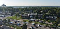
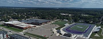
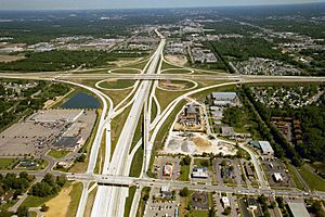
Wyoming City Hall. Water tower near Gezon Park in Wyoming's panhandle. Panoramic view east down 28th Street, the city's main commercial route. |
|||
|
|||
| Motto(s):
City of Vision and Progress
|
|||
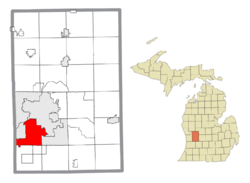
Location within Kent County
|
|||
| Country | United States | ||
| State | Michigan | ||
| County | Kent | ||
| Organized | 1848 (Wyoming Township) | ||
| Incorporated | 1959 | ||
| Government | |||
| • Type | Mayor–council | ||
| Area | |||
| • Total | 24.95 sq mi (64.62 km2) | ||
| • Land | 24.74 sq mi (64.08 km2) | ||
| • Water | 0.21 sq mi (0.54 km2) | ||
| Elevation | 666 ft (203 m) | ||
| Population
(2020)
|
|||
| • Total | 76,501 | ||
| • Density | 3,092.07/sq mi (1,193.84/km2) | ||
| Time zone | UTC-5 (EST) | ||
| • Summer (DST) | UTC-4 (EDT) | ||
| ZIP code(s) | |||
| Area code(s) | 616 | ||
| FIPS code | 26-88940 | ||
| GNIS feature ID | 1627295 | ||
Wyoming is a city in Kent County, Michigan. In 2020, about 76,501 people lived there. It's the second largest city in the Grand Rapids metropolitan area, right next to Grand Rapids. It's also the second biggest city in West Michigan.
People first settled in the Wyoming area in 1832, near Buck Creek. It became Wyoming Township in 1848. For many years, Wyoming was a farming area that supplied goods to Grand Rapids. When the Grand Rapids, Holland and Chicago Railway arrived, more people started moving to the area, making it a suburban place.
In 1933, Grandville became its own city, separate from Wyoming Township. Wyoming continued to grow, especially after the General Motors Stamping Division Plant opened. There were some disagreements with Grand Rapids and Grandville about land. Finally, in 1959, Wyoming Township officially became the city of Wyoming.
After becoming a city, Wyoming became a popular spot for shopping and fun along 28th Street. Places like Rogers Plaza and Studio 28 opened. But in the 1980s, things started to change. When RiverTown Crossings mall opened in Grandville in 1999, many stores left Wyoming.
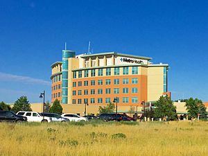
In the early 2000s, new development moved to the southwest part of Wyoming, closer to RiverTown Crossings. This continued around Metro Health Hospital after it opened in 2007. However, the General Motors plant closed in 2009. Since the mid-2010s, Wyoming has been working to improve its center on 28th Street with the "28 West" project. They are also redeveloping the old General Motors land, now called "Site 36."
Contents
History of Wyoming
Early Settlement and Township Formation
The area that is now Wyoming was first settled in 1832. It was one of the first places in Kent County to have people living there. For the next 16 years, it was part of the Township of Byron. During this time, the area known as Grandville grew, with mills using Buck Creek for power.
In 1848, Byron Township split, and the northern half became Wyoming Township. The name "Wyoming" came from Wyoming County, New York, where many of the first settlers were from. A small part of the new township, north of the Grand River, was given to Walker Township because it was hard to manage.
Wyoming Township: Growth and Changes (1848–1959)
Over the next 50 years, Wyoming Township grew slowly. The settlement of Grandville in the northwest corner grew the most. By 1884, it was the Village of Grandville, and by 1893, it separated from the township. Grandville later expanded to its current size. Only a small "panhandle" section of Wyoming, south of 50th Street, remained.
Around 1870, a small community called Fisher's Station grew up around a train station on the Grand Rapids and Indiana Railroad. It got a post office in 1871.
The next big area of growth was in the northeast part of the township. The city of Grand Rapids started adding parts of Wyoming Township to its own city. By 1891, Grand Rapids had taken a square mile of land from Wyoming. More land was added in 1916. Other attempts to add land to Grand Rapids happened over the next 50 years, but most failed.
Many workers for Grand Rapids' furniture factories lived in the northern parts of Wyoming. This area included neighborhoods like Urbandale, Galewood, and Burlingame. These areas were sometimes called GUB. The Godfrey-Lee school district was the first school district in the township. There were also important places like the Pere Marquette Rail yard and the Kelvinator plant.
In 1939, people tried to make the GUB area its own city called Lee, but it didn't happen. Another attempt to join Grand Rapids in 1949 also failed. A final attempt by Grand Rapids to annex land in 1958 failed, partly because local school districts wanted to keep their land.
Another important area developed along Division Avenue. The northern part was called Godwin, which also had its own schools. This area was split between Wyoming and Paris Township. In the 1950s, the county planned to move the airport to its current location. Both the school district and Wyoming Township wanted to control this land. Grand Rapids also wanted it, leading to a big disagreement.
During this time, Wyoming Township was able to become a new city in 1958, with its government starting in 1959. Over the next few years, there were votes to add more land to Grand Rapids, but only the airport was eventually annexed by Grand Rapids. A major reason the Godwin area was important for annexation was the GM Fisher Body Plant, built in 1936.
South of Godwin was the Fishers Station area. It grew because of the railroad that ran from Grand Rapids to Kalamazoo. Later, it was renamed Home Acres. In 1931, there was a proposal to make this area, along with part of Godwin, a village called Emerson, but it failed. Another attempt to call it South Grand Rapids also failed. The Kelloggsville area became a school district split between Wyoming and Paris Township (which later became Kentwood).
The vote to become a city was tried twice. The first time in 1956, it failed by a small number of votes. Some people spread rumors about the city's water supply, suggesting they should join Grand Rapids instead. At that time, many new homes were being built, and water was a big concern. A second vote was held in 1958, and this time it passed by 1,442 votes.
City of Wyoming: Modern Era (1959–present)
In the 1960s, the new city of Wyoming started several big projects. They built a sewage plant to stop pollution in Buck Creek and the Grand River. They also completed a water plant in Holland and built a pipeline to bring water to Wyoming. These projects helped shape the city.
New developments continued, especially along 28th Street. Rogers Plaza, one of the first indoor malls in the state, opened in 1961, along with the Wyoming Village Mall. Flowerland Fruitbasket also opened in 1961, selling lawn care items and plants. Four years later, in 1965, Studio 28 opened on 28th Street. It grew over the years to become the world's first multiplex (a movie theater with many screens) and the largest in the world by 1988.
After the Rivertown Crossings Mall opened in Grandville in 1999, many businesses left 28th Street in Wyoming to move there. More businesses closed during the Great Recession, and the GM Fisher Body Plant shut down in 2008. Studio 28 also closed in 2008, and by 2011, many stores on 28th Street were empty.
In the 2010s, new development started in southern Wyoming. Gordon Food Service expanded its main office, and Metro Hospital moved to the area, bringing new businesses. Development around Rivertown Crossings Mall also boosted growth in the "panhandle" part of the city.
In 2013, Wyoming introduced the "28 West plan." This plan aims to make downtown Wyoming, along 28th Street, a more friendly place for people to walk, with more restaurants, shops, and entertainment. In 2016, parts of the Wyoming Village Mall were torn down to make way for new roads and attract developers.
Wyoming's Geography
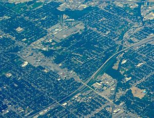
Wyoming is located southwest of Grand Rapids and south of the Grand River. To the west are Grandville and Georgetown Township in Ottawa County. Byron Township is to the south, and the city of Kentwood is to the east.
Major highways run through Wyoming:
- U.S. Highway 131 (US 131) is on the eastern side.
- Interstate 196 (I-196) runs southwest to northeast along the Grand River.
- The M-6 (Paul B. Henry Freeway) runs along the south side, connecting I-196 with US 131 and I-96.
- M-11 goes east-west through the north of the city, also connecting with I-196, US 131, and I-96.
The United States Census Bureau says that Wyoming covers about 24.87 square miles (64.41 km2). Most of this, 24.64 square miles (63.82 km2), is land, and 0.23 square miles (0.60 km2) is water.
Wyoming's Weather
Wyoming is on the edge of the "snow belt." This means it gets more snow from lake effect snow coming off Lake Michigan. The lake also helps keep the area east of Wyoming warmer than usual.
The highest temperature ever recorded in the area was 102°F (39°C) in June. The lowest was -22°F (-30°C) in January. The sun shines about 46% of the time. Temperatures reach at least 65°F (18°C) about 43% of the year. The temperature drops below 32°F (0°C) almost 40% of the time.
| Climate data for Wyoming, Michigan | |||||||||||||
|---|---|---|---|---|---|---|---|---|---|---|---|---|---|
| Month | Jan | Feb | Mar | Apr | May | Jun | Jul | Aug | Sep | Oct | Nov | Dec | Year |
| Mean daily maximum °F | 30 | 32 | 42 | 57 | 69 | 79 | 83 | 81 | 73 | 61 | 46 | 34 | 57 |
| Mean daily minimum °F | 16 | 17 | 25 | 36 | 46 | 56 | 60 | 59 | 51 | 41 | 31 | 21 | 38 |
| Average rainfall inches | 2.0 | 1.5 | 2.6 | 3.5 | 3.0 | 3.6 | 3.5 | 3.4 | 3.7 | 2.8 | 3.3 | 2.6 | 35.5 |
| Average snowfall inches | 20.2 | 11.9 | 10.0 | 3.0 | 0 | 0 | 0 | 0 | 0 | .7 | 7.7 | 18.1 | 71.6 |
| Mean daily maximum °C | −1 | 0 | 6 | 14 | 21 | 26 | 28 | 27 | 23 | 16 | 8 | 1 | 14 |
| Mean daily minimum °C | −9 | −8 | −4 | 2 | 8 | 13 | 16 | 15 | 11 | 5 | −1 | −6 | 4 |
| Average rainfall mm | 51 | 38 | 66 | 89 | 76 | 91 | 89 | 86 | 94 | 71 | 84 | 66 | 900 |
| Average snowfall cm | 51 | 30 | 25 | 7.6 | 0 | 0 | 0 | 0 | 0 | 1.8 | 20 | 46 | 182 |
| Source: Weatherbase | |||||||||||||
Neighboring Cities and Townships
 |
Walker | Grand Rapids |  |
|
| Grandville | Kentwood | |||
| Hudsonville | Byron Township | Gaines Township |
Wyoming's Economy
In 2000, Wyoming had 10 main types of industries.
- Manufacturing (making things) was the largest, at 30%.
- Retail (stores) was 16%.
- Education, health, and social services were 15%.
- Transportation, warehousing, and utilities made up 3%.
Wyoming's manufacturing sector is the biggest in West Michigan. It produces:
- Auto parts
- Industrial machinery
- Commercial printing
- Plastics
- Food processing
- Electronics
- Tools and dies
- Concrete supplies
- Fire engines
After the Rivertown Crossings Mall opened in Grandville, many big stores in Wyoming closed, including the long-standing Roger's Department Store. To help local businesses, the city of Wyoming created a Downtown Development Authority in 1999.
In the 2000s, there were plans to improve the 28th Street area. In 2013, the city launched the "28 West plan." This plan aims to make downtown Wyoming, along 28th Street, a more inviting place for people to visit, with more food, shops, and entertainment. In June 2016, work began on the 28 West plan, including tearing down part of the Wyoming Village Mall to create new roads and attract developers.
Largest Employers in Wyoming
Here are the largest employers in Wyoming, based on the city's 2021 financial report:
| # | Employer | # of Employees | % of city employment |
|---|---|---|---|
| 1 | Gordon Food Service | 5,000 | 9.14% |
| 2 | Metro Health Hospital | 2,100 | 3.84% |
| 3 | GM Components Holdings | 1,200 | 2.19% |
| 4 | Michigan Turkey Products | 780 | 1.43% |
| 5 | Benteler | 691 | 1.22% |
| 6 | Booking.com | 550 | 1.01% |
| 7 | Kellogg's Snacks | 500 | 0.91% |
| 8 | Lumbermen's Inc | 500 | 0.91% |
| 9 | Advantage Solutions | 450 | 0.82% |
| 10 | Undercar Products Inc. | 416 | 0.76% |
Arts and Culture in Wyoming
Wyoming has 21 parks that cover about 665 acres (2.69 km2). These parks offer many activities. In the last ten years, the parks department has worked to improve the city's parks. Many parks have been rebuilt with new equipment, splash pads, and facilities. They also added a small skateboard park. The city has a Senior Center that offers activities for older citizens.
The city is also home to the Kent Trails system. This system turned old train lines into bike paths. It's a team effort between several local governments. The newest addition to Wyoming's park system is a Dog Park, located next to Marquette Park. It's a private park for registered members.
In 2002, the new Wyoming Public Library was built. It's owned by the city but run by the Kent District Library System. The library is a 48,950 square foot (4,548 m2) building with over 112,046 items. It's the busiest branch in the Kent District system, with 670,842 items checked out and 439,599 visits in 2009. About 76% of the city's population has a library card. The building also houses the Wyoming Historical Commission, which keeps historical materials about the city. It has a library for the blind and an art gallery too.
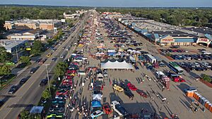
Since 2005, the Wyoming-Kentwood Chamber of Commerce has organized the 28th Street Metro Cruise. This event brings car fans from all over the region. It stretches for 15 miles (24 km), starting in Grandville and ending in Cascade Township. The cruise takes place on the last Friday and Saturday of August.
Religion in Wyoming
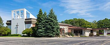
The first churches in Wyoming were started by Christian Reformed Dutch settlers. Grandville Avenue Christian Reformed Church was founded in 1891 and is now part of The Potter's House school. Holy Name of Jesus Catholic Church was built in 1908 for Roman Catholics in Wyoming. The Episcopal community started Holy Trinity Episcopal Church in 1957. The Assemblies of God built a church in 1929 and moved to their current location on 44th Street in 1977. This church can seat 1,400 people.
Wyoming's Population
| Historical population | |||
|---|---|---|---|
| Census | Pop. | %± | |
| 1850 | 543 | — | |
| 1860 | 1,237 | 127.8% | |
| 1870 | 1,786 | 44.4% | |
| 1880 | 2,117 | 18.5% | |
| 1890 | 3,234 | 52.8% | |
| 1900 | 3,396 | 5.0% | |
| 1910 | 5,284 | 55.6% | |
| 1920 | 5,702 | 7.9% | |
| 1930 | 16,931 | 196.9% | |
| 1940 | 20,396 | 20.5% | |
| 1950 | 28,977 | 42.1% | |
| 1960 | 45,829 | 58.2% | |
| 1970 | 56,560 | 23.4% | |
| 1980 | 59,616 | 5.4% | |
| 1990 | 63,891 | 7.2% | |
| 2000 | 69,368 | 8.6% | |
| 2010 | 72,125 | 4.0% | |
| 2020 | 76,501 | 6.1% | |
| 2023 (est.) | 77,451 | 7.4% | |
| U.S. Decennial Census 2010 2020 |
|||
| Race / Ethnicity | Pop 2010 | Pop 2020 | % 2010 | % 2020 |
|---|---|---|---|---|
| White alone (NH) | 49,208 | 44,409 | 68.23% | 58.05% |
| Black or African American alone (NH) | 4,756 | 6,428 | 6.59% | 8.40% |
| Native American or Alaska Native alone (NH) | 292 | 217 | 0.40% | 0.28% |
| Asian alone (NH) | 1,992 | 2,430 | 2.76% | 3.18% |
| Pacific Islander alone (NH) | 26 | 20 | 0.04% | 0.03% |
| Some Other Race alone (NH) | 93 | 226 | 0.13% | 0.30% |
| Mixed Race/Multi-Racial (NH) | 1,748 | 3,348 | 2.42% | 4.38% |
| Hispanic or Latino (any race) | 14,010 | 19,423 | 19.42% | 25.39% |
| Total | 72,125 | 76,501 | 100.00% | 100.21% |
Note: the US Census treats Hispanic/Latino as an ethnic category. This table excludes Latinos from the racial categories and assigns them to a separate category. Hispanics/Latinos can be of any race.
2020 Census Data
In 2020, Wyoming had a population of 76,501 people.
| Race / Ethnicity | Pop 2010 | Pop 2020 | % 2010 | % 2020 |
|---|---|---|---|---|
| White alone (NH) | 49,208 | 44,409 | 68.23% | 58.05% |
| Black or African American alone (NH) | 4,756 | 6,428 | 6.59% | 8.40% |
| Native American or Alaska Native alone (NH) | 292 | 217 | 0.40% | 0.28% |
| Asian alone (NH) | 1,992 | 2,430 | 2.76% | 3.18% |
| Pacific Islander alone (NH) | 26 | 20 | 0.04% | 0.03% |
| Some Other Race alone (NH) | 93 | 226 | 0.13% | 0.30% |
| Mixed Race/Multi-Racial (NH) | 1,748 | 3,348 | 2.42% | 4.38% |
| Hispanic or Latino (any race) | 14,010 | 19,423 | 19.42% | 25.39% |
| Total | 72,125 | 76,501 | 100.00% | 100.00% |
Note: the US Census treats Hispanic/Latino as an ethnic category. This table excludes Latinos from the racial categories and assigns them to a separate category. Hispanics/Latinos can be of any race.
2010 Census Data
In 2010, there were 72,125 people living in Wyoming. There were 26,970 households and 18,128 families. The city had about 2,927 people per square mile (1,130 per km2).
The racial makeup of the city was:
- 75.8% White
- 7.2% African American
- 0.6% Native American
- 2.8% Asian
- 9.6% from other races
- 3.8% from two or more races
About 19.4% of the population was Hispanic or Latino (of any race).
In the households:
- 37.2% had children under 18.
- 47.1% were married couples.
- 14.4% had a female head of household with no husband.
- 5.7% had a male head of household with no wife.
- 32.8% were not families.
About 25.6% of all households were individuals living alone. 7.3% had someone aged 65 or older living alone. The average household had 2.66 people, and the average family had 3.22 people.
The average age in the city was 32.1 years.
- 27.1% of residents were under 18.
- 10.5% were between 18 and 24.
- 29.9% were between 25 and 44.
- 23.5% were between 45 and 64.
- 9% were 65 or older.
The city was 49.3% male and 50.7% female.
Education in Wyoming
Wyoming is served by 8 different school districts:
- Grandville Public Schools (southwest)
- Byron Center Public Schools (south, near Metro Health)
- Wyoming Public Schools (central)
- Kelloggsville Public Schools (southeast)
- Kentwood Public Schools (south of 56th St and east of railroad tracks)
- Grand Rapids Public Schools (small section near Hall St and Freeman Avenue)
- Godwin Heights Public Schools (northeast)
- Godfrey-Lee Public Schools (northern section)
Out of these eight districts, four have most of their school buildings outside of Wyoming: Grand Rapids Public Schools, Kentwood Public Schools, Byron Center Public Schools, and Grandville Public Schools.
The other four districts have many schools within Wyoming city limits:
- 13 elementary schools
- 3 out of 13 middle schools
- 4 out of 8 high schools
- Godfrey-Lee has a combined middle and high school in the city.
There are also private schools:
- The Potter's House, a Christian K-12 school, has its high school campus in Wyoming.
- Holy Trinity Lutheran School is a Pre-K to 8th grade school of the Wisconsin Evangelical Lutheran Synod.
- The Roman Catholic Diocese of Grand Rapids has two K-8 schools: St John Vianney School and San Juan Diego Academy.
For higher education, students can attend:
- Grand Rapids Community College in downtown Grand Rapids.
- Grand Valley State University in Allendale, northwest of Wyoming.
- Other universities in Lansing, Big Rapids, and Kalamazoo.
- Nearby colleges include Hope College in Holland, Davenport University in Caledonia Township, Calvin College, Aquinas College, and Cornerstone University in Grand Rapids.
- Grace Bible College is also nearby.
- The Protestant Reformed Theological Seminary is located in Wyoming.
Wyoming's Infrastructure
Public Transportation
Wyoming is part of The Rapid, which is the public transit system for the Grand Rapids area. The Rapid runs 8 of its 26 bus routes through Wyoming (Routes 1, 3, 8, 10, 16, 24, 28, and 44).
The U.S. Department of Transportation is helping to fund a new transit system for the area. It will be a bus rapid transit system that runs along Division Avenue on the east side of the city. This new line will also be operated by The Rapid.
Utilities and Services
The city of Wyoming provides water and sewer services to most residents. Electricity is supplied by Consumers Energy, and natural gas is usually supplied by DTE Energy.
Garbage collection is handled by private companies that homeowners hire. By law, these companies must take garbage to the county incinerator. The city also has a drop-off center for yard waste.
For phone and cable services, both AT&T and Comcast are available. Cell phone service is generally good, with many cell towers in the area.
Notable People from Wyoming
- Chris Kaman, professional basketball player
- Buster Mathis, professional boxer
- Buster Mathis Jr., professional boxer
- Drew Neitzel, professional basketball player
- Dave Rozema, former baseball pitcher
See also
 In Spanish: Wyoming (Míchigan) para niños
 | Charles R. Drew |
 | Benjamin Banneker |
 | Jane C. Wright |
 | Roger Arliner Young |


