
Zalma, Missouri facts for kids
Quick facts for kids
Zalma, Missouri
|
|
|---|---|

Location of Zalma, Missouri
|
|
| Country | United States |
| State | Missouri |
| County | Bollinger |
| Area | |
| • Total | 0.21 sq mi (0.54 km2) |
| • Land | 0.21 sq mi (0.53 km2) |
| • Water | 0.00 sq mi (0.00 km2) |
| Elevation | 394 ft (120 m) |
| Population
(2020)
|
|
| • Total | 73 |
| • Density | 354.37/sq mi (136.50/km2) |
| Time zone | UTC-6 (Central (CST)) |
| • Summer (DST) | UTC-5 (CDT) |
| ZIP code |
63787
|
| Area code(s) | 573 |
| FIPS code | 29-81430 |
| GNIS feature ID | 2786553 |
Zalma is a small community in southeast Missouri, United States. It's located in Bollinger County, right by the Castor River. The river here makes a cool horseshoe bend!
Zalma used to be called "Bollinger's Mill." The name changed to Zalma when the railroad came to town. It was named after a railroad worker, Zalma Block. Some people also say "Zalma" is a Native American word meaning "the end."
As of 2020, about 73 people live in Zalma. It's part of the larger Cape Girardeau-Jackson area. Zalma is a great place for outdoor fun like deer hunting, fishing, bird watching, horseback riding, and hiking. You can also find Blue Pond nearby, which is the deepest natural pond in Missouri!
Contents
Zalma's Story: A Look Back
The story of Zalma began around 1800. A person named Urban Asherbranner settled here. He built a simple dam and a water mill to grind corn. Another settler, Philip Bollinger, lived nearby.
Later, the mill was taken over by the Bollinger family. Daniel Bollinger came to Zalma around 1850 to run the mill. He and his sister, Catherine, fixed the dam and kept the mill working.
During the Civil War, Daniel passed away. His wife, Eleanora, continued to operate the mill with help. Sadly, the mill burned down sometime between 1863 and 1873.
Zalma got its first post office in November 1876. Later, a new mill was built with machinery to grind wheat and corn. It also had a machine to clean and prepare wool. This mill also burned down in 1897.
In 1880, a railroad was built connecting Cape Girardeau and Delta. A special track was later added to connect Zalma to this railroad. However, the railroad was removed in the early 1930s.
The town's economy got a boost when the timber industry arrived. Companies bought lots of white oak trees. Factories were set up in Zalma to cut wood for things like boxes. These factories gave jobs to many people, including women who stacked wood to dry in the sun.
Learning in Zalma: The School District
The Zalma R-V School District serves students in southern Bollinger County. It's one of the smaller public schools in Southeast Missouri, with about 250 students from kindergarten to 12th grade.
The school's mascot is the bulldog, and their colors are green and gold. Students can join many clubs and activities, such as:
- FCCLA (Family, Career & Community Leaders of America)
- Student Council
- Junior and Senior Beta Club
- Pep Club
- Fellowship of Christian Athletes (FCA)
- Future Business Leaders of America (FBLA)
- Speech Team
- Smokebusters
- The ZHS Concert Choir
For sports, Zalma High School offers:
- Boys' basketball
- Girls' volleyball
- Boys' baseball
- Girls' softball
- Co-ed cheerleading
- Cross country
- track and field
The Zalma Bulldogs boys' basketball team won the state championship in 1939–1940. The Zalma Lady Bulldogs volleyball team won the state championship in 1990–1991. They even made it to the state championship game in the next two years!
Most adults in Zalma have at least a high school diploma. Some also have a bachelor's degree or higher.
Where is Zalma? Its Geography
Zalma is located in the southwest part of Bollinger County. Missouri Route 51 runs right through the community. The Castor River flows along the north side of town.
Nearby towns include Marble Hill (about 11 miles northeast), Gipsy (about 5.5 miles west), and Arab (three miles south).
The United States Census Bureau says Zalma covers a total area of about 0.19 square miles (0.49 square kilometers). Most of this area is land, with a very small amount of water.
Who Lives in Zalma? Population Facts
The population of Zalma has changed over the years. Here's how many people have lived there during different census counts:
| Historical population | |||
|---|---|---|---|
| Census | Pop. | %± | |
| 1910 | 197 | — | |
| 1920 | 259 | 31.5% | |
| 1930 | 204 | −21.2% | |
| 1940 | 169 | −17.2% | |
| 1950 | 137 | −18.9% | |
| 1960 | 141 | 2.9% | |
| 1970 | 118 | −16.3% | |
| 1980 | 121 | 2.5% | |
| 1990 | 83 | −31.4% | |
| 2000 | 93 | 12.0% | |
| 2010 | 122 | 31.2% | |
| 2020 | 73 | −40.2% | |
| U.S. Decennial Census | |||
Getting Around: Transportation
State Highway 51 goes directly through Zalma, making it easy to get in and out of town. The closest major four-lane highway, Interstate 55, is about 40 miles (64 km) east in Cape Girardeau. The nearest airport is Twin City Airpark in Marble Hill.
Places of Worship: Churches
Zalma has two churches. The oldest is the Zalma Missionary Baptist Church. The other, larger church is the Zalma General Baptist Church.
Images for kids
-
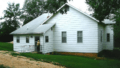
The building owned by Zalma Missionary Baptist Church, the first Baptist church in Zalma.

See also
 In Spanish: Zalma (Misuri) para niños
