
Adams, Massachusetts facts for kids
Quick facts for kids
Adams
|
|||
|---|---|---|---|

|
|||
|
|||

Location in Berkshire County and the state of Massachusetts
|
|||
| Country | United States | ||
| State | Massachusetts | ||
| County | Berkshire | ||
| Settled | 1762 | ||
| Incorporated | 1778 | ||
| Government | |||
| • Type | Board of Selectmen Representative town meeting | ||
| Area | |||
| • Total | 23.0 sq mi (59.5 km2) | ||
| • Land | 22.9 sq mi (59.3 km2) | ||
| • Water | 0.08 sq mi (0.2 km2) | ||
| Elevation | 799 ft (244 m) | ||
| Population
(2020)
|
|||
| • Total | 8,166 | ||
| • Density | 355.5/sq mi (137.24/km2) | ||
| Time zone | UTC−5 (Eastern) | ||
| • Summer (DST) | UTC−4 (Eastern) | ||
| ZIP Code |
01220
|
||
| Area code(s) | 413 | ||
| FIPS code | 25-00555 | ||
| GNIS feature ID | 0619415 | ||


Adams is a town in northern Berkshire County, Massachusetts, United States. It is part of the Pittsfield area. In 2020, about 8,166 people lived there.
Contents
History of Adams
Adams was first settled in 1745. In 1762, a man named Nathan Jones bought the land. The town was officially named Adams in 1778. It was named after Samuel Adams, a famous leader during the American Revolution. He also signed the Declaration of Independence.
Many early settlers were Quakers, who are a religious group. They came from Rhode Island in the 1760s. A very important person, Susan B. Anthony, was born in Adams in 1820. She was a leader in the fight for civil rights, to end slavery, and for women's right to vote. Her childhood home is now a museum.
The Hoosic River runs through Adams. Its water power was used for mills that made things like wool, cotton, and lumber. In 1814, the first cotton mill opened. This created many jobs, and the town's population grew a lot. The opening of the Hoosac Tunnel in 1875 also helped Adams grow.
In the late 1800s, several large brick buildings were built on Park Street. These buildings were used for shops and offices.
President William McKinley visited Adams twice. He was friends with the Plunkett brothers, who started a big textile company. In 1903, a statue of President McKinley was put up next to the Adams Free Library to honor him.
The large textile factory in Adams closed in 1958. Many textile jobs moved to other states. Today, the main factory left in Adams is Specialty Minerals. It mines and processes limestone for things like antacids and paper whiteners.
Adams now focuses on tourism. People visit for its history, outdoor activities, and its closeness to museums in North Adams.
Geography of Adams
Adams is located in a valley near the Hoosic River. It is surrounded by mountains. To the west is the Taconic Range, and to the east is the Hoosac Range.
The town includes the top of Mount Greylock, which is the highest point in Massachusetts. Mount Greylock is part of a state park and is a stop on the Appalachian Trail. It has inspired many writers. Adams also touches a part of Savoy Mountain State Park.
Adams is next to North Adams to the north. It borders Florida and Savoy to the east. To the south are Savoy and Cheshire. To the west are New Ashford and Williamstown.
Climate in Adams
Adams has a typical New England climate. Temperatures are often below 50 degrees Fahrenheit for about 205 days each year. The town gets a lot of rain, about 44.5 inches per year. Snow covers the ground for about 77 days a year.
Population of Adams
| Historical population | ||
|---|---|---|
| Year | Pop. | ±% |
| 1850 | 6,172 | — |
| 1860 | 6,924 | +12.2% |
| 1870 | 12,090 | +74.6% |
| 1880 | 5,591 | −53.8% |
| 1890 | 9,213 | +64.8% |
| 1900 | 11,134 | +20.9% |
| 1910 | 13,026 | +17.0% |
| 1920 | 12,967 | −0.5% |
| 1930 | 12,697 | −2.1% |
| 1940 | 12,608 | −0.7% |
| 1950 | 12,034 | −4.6% |
| 1960 | 12,391 | +3.0% |
| 1970 | 11,772 | −5.0% |
| 1980 | 10,381 | −11.8% |
| 1990 | 9,445 | −9.0% |
| 2000 | 8,809 | −6.7% |
| 2010 | 8,485 | −3.7% |
| 2020 | 8,166 | −3.8% |
| 2022* | 8,047 | −1.5% |
| * = population estimate. Source: United States Census records and Population Estimates Program data. |
||
In 2020, the population of Adams was 8,166 people. It is the third most populated town in Berkshire County.
Education in Adams
Adams shares a school district with the nearby towns of Cheshire and Savoy.
- Students in Kindergarten to 3rd Grade go to Plunkett Elementary School.
- Students from 4th to 7th Grade attend Hoosac Valley Middle School.
- Students from 8th to 12th Grade go to Hoosac Valley High School. This high school is just over the border in Cheshire. The school colors are red and white, and their sports teams are called the "Hurricanes."
Adams is also home to the Berkshire Arts & Technology Charter Public School (BArT). This is a free public school for grades six through twelve.
High school students can also choose to go to the public Charles H. McCann Technical High School in North Adams. There is also a private Catholic school in Adams, Saint Stanislaus Kostka, for students from pre-kindergarten through eighth grade.
For college, the closest community college is Berkshire Community College in Pittsfield. The closest state college is Massachusetts College of Liberal Arts in North Adams. The nearest university is University of Massachusetts Amherst.
Transportation in Adams
Massachusetts Route 8 is the main road that goes north and south through Adams. Massachusetts Route 116 starts in Adams and goes southeast towards Springfield.
Passenger trains used to run through Adams until 1953. The old train station, Adams station, is still there. Today, you can catch an Amtrak train about 15 miles south in Pittsfield.
A former freight rail line in Adams has been turned into a paved path called the Ashuwillticook Rail Trail. This is a popular spot for walking and biking. Bus service is available through the Berkshire Regional Transit Authority. For air travel, the closest airport with international flights is Albany International Airport in New York.
Sites of Interest in Adams
- Adams Agricultural Fair
- Susan B. Anthony Birthplace Museum
- Ashuwillticook Rail Trail
- Greylock Glen
- Hoosac Valley Train
- Maple Street Cemetery
- Mount Greylock State Reservation
- Pittsfield & North Adams Passenger Station and Baggage & Express House
- Quaker Meeting House (built in 1782)
- St. Stanislaus Parish Roman Catholic Church
- Summer Street Historic District
Notable People from Adams
- Daniel Read Anthony (1824–1904), a publisher and abolitionist
- Susan B. Anthony (1820–1906), a leader for women's right to vote
- George N. Briggs (1796–1861), a former Governor of Massachusetts
- Lona Cohen (1913–1992), a Soviet spy
- George P. Lawrence (1859–1917), a US congressman
- Dale Long (1926–1991), a Major League Baseball player
- Albert L. Phillips (1824–1893), a Wisconsin politician
- Stacy Schiff (born 1961), an author
Images for kids
-
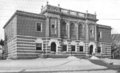
Adams public library, 1899
-
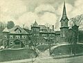
Congregational Church, Club House and Parish House around 1905
-
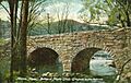
Bridge at Maple Grove around 1910
-
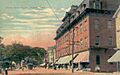
Center Street Square around 1910
-
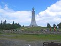
The War Memorial Tower atop Mount Greylock
-
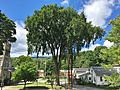
The last American elm tree in downtown Adams is located at the former St. Mark's Episcopal Church on Commercial Street. The church was built in 1881.
-

William McKinley statue in the square in front of the library (2004 photo)
-

A view of Adams from atop Mount Greylock


See also
 In Spanish: Adams (Massachusetts) para niños
