New Ashford, Massachusetts facts for kids
Quick facts for kids
New Ashford, Massachusetts
|
|
|---|---|

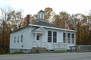
New Ashford Town Hall
|
|

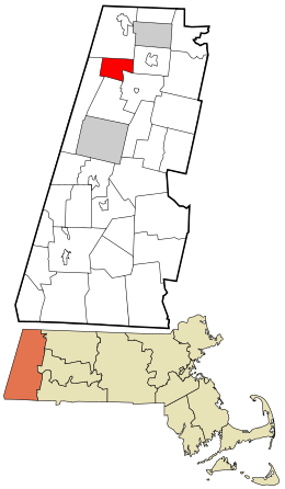
Location in Berkshire County and the state of Massachusetts.
|
|
| Country | United States |
| State | Massachusetts |
| County | Berkshire |
| Settled | 1762 |
| Incorporated | 1835 |
| Government | |
| • Type | Open town meeting |
| Area | |
| • Total | 13.48 sq mi (34.91 km2) |
| • Land | 13.46 sq mi (34.87 km2) |
| • Water | 0.02 sq mi (0.04 km2) |
| Elevation | 1,256 ft (383 m) |
| Population
(2020)
|
|
| • Total | 250 |
| • Density | 18.5/sq mi (7.16/km2) |
| Time zone | UTC-5 (Eastern) |
| • Summer (DST) | UTC-4 (Eastern) |
| ZIP code |
01237
|
| Area code(s) | 413 |
| FIPS code | 25-44385 |
| GNIS feature ID | 0598751 |
New Ashford is a small town located in Berkshire County, Massachusetts, in the United States. It's part of the larger Pittsfield area. In 2020, about 250 people lived there.
Contents
History of New Ashford
New Ashford was first settled in 1762. It officially became a town on November 4, 1835. The town was named after Ashford, Connecticut, which is where many of its first residents came from. For most of its history, New Ashford has been a quiet farming community. There were not many factories or mills built here.
A Special Voting Place
For a few years starting in 1916, New Ashford had a unique role in United States Presidential Elections. It was the first place in the country to cast its votes! This is similar to how Dixville Notch, New Hampshire does it today.
On November 2, 1920, something very important happened in New Ashford. After the Nineteenth Amendment was passed, women gained the right to vote. Ms. Phoebe Jordan became the first woman to vote in a national election right here in New Ashford. The old wooden ballot box used on that historic day is still kept in the town hall and is even used today.
Brodie Mountain Ski Area
New Ashford is also home to the former Brodie Mountain ski area. This was once a very popular place for skiing. It started in 1939 on the Gregory Marakoff farm.
Geography and Nature
New Ashford is a small town, covering about 34.9 square kilometers (13.5 square miles). Only a tiny part of this area, about 0.10%, is water. It is the third-smallest town in Berkshire County by land area.
Where is New Ashford?
New Ashford is surrounded by several other towns:
- To the north: Williamstown
- To the east: Adams
- To the southeast: Cheshire
- To the south: Lanesborough
- To the west: Hancock
The town is about 11 miles (18 km) north of Pittsfield. It's also closer to cities like Hartford and Albany than it is to Boston, the capital of Massachusetts.
Mountains and Trails
New Ashford sits in a natural valley within the Taconic Mountains. These mountains are often considered part of the Berkshires. To the east, you can see Mount Greylock State Reservation. Mount Greylock itself, the highest point in Massachusetts, is just northeast of New Ashford.
The peak of Saddle Ball Mountain, which is part of the Mount Greylock range, is located within the eastern part of New Ashford. It's the highest point in the town, reaching about 3,220 feet (980 meters) above sea level. The Mount Greylock Scenic Drive, a road that goes to the mountain's peak, passes through the eastern part of town. The famous Appalachian Trail also crosses through this area. To the west, Brodie Mountain runs along the town's western border.
Transportation in New Ashford
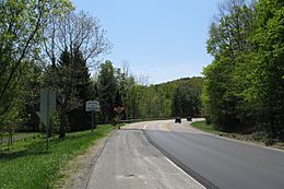
U.S. Route 7 is the main road that goes through the center of New Ashford. There are no state routes that pass through the town.
If you want to travel by train, the closest train service (Amtrak and CSX) is in Pittsfield. Bus service is provided by the Berkshire Regional Transit Authority. For air travel, there are two local airports nearby: Harriman and West Airport in North Adams and Pittsfield Municipal Airport. The closest airport with flights to other states is Albany International Airport in New York.
Population and People
| Historical population | ||
|---|---|---|
| Year | Pop. | ±% |
| 1850 | 186 | — |
| 1860 | 239 | +28.5% |
| 1870 | 208 | −13.0% |
| 1880 | 203 | −2.4% |
| 1890 | 125 | −38.4% |
| 1900 | 107 | −14.4% |
| 1910 | 92 | −14.0% |
| 1920 | 116 | +26.1% |
| 1930 | 75 | −35.3% |
| 1940 | 87 | +16.0% |
| 1950 | 118 | +35.6% |
| 1960 | 165 | +39.8% |
| 1970 | 183 | +10.9% |
| 1980 | 159 | −13.1% |
| 1990 | 192 | +20.8% |
| 2000 | 247 | +28.6% |
| 2010 | 228 | −7.7% |
| 2020 | 250 | +9.6% |
| 2022* | 249 | −0.4% |
| * = population estimate. Source: United States Census records and Population Estimates Program data. |
||
As of the year 2000, New Ashford had 247 people living in 94 households. Out of these, 72 were families. New Ashford is one of the least populated towns in Berkshire County and one of the smallest towns in all of Massachusetts.
About 36% of the households had children under 18 living with them. Most households (66%) were married couples. The average household had about 2.63 people.
The population was spread out by age:
- About 29% were under 18 years old.
- About 30% were between 25 and 44 years old.
- About 31% were between 45 and 64 years old.
- About 9% were 65 years or older.
The average age in town was 38 years.
Education in New Ashford
Students in New Ashford attend different schools depending on their grade level.
Elementary and Middle School
Children from pre-kindergarten up to sixth grade go to Pontoosuc Regional Elementary School. Students from New Ashford share this school with students from Lanesborough.
High School
For seventh through twelfth grades, students attend Mount Greylock Regional School in Williamstown.
Higher Education Options
If students want to continue their education after high school, there are several colleges nearby:
- The closest community college is Berkshire Community College in Pittsfield.
- The nearest state college is Massachusetts College of Liberal Arts in North Adams.
- The closest state university is the University of Massachusetts Amherst.
- A private college, Williams College, is located in the neighboring town of Williamstown.
See also
 In Spanish: New Ashford para niños
 | Janet Taylor Pickett |
 | Synthia Saint James |
 | Howardena Pindell |
 | Faith Ringgold |


