Hancock, Massachusetts facts for kids
Quick facts for kids
Hancock, Massachusetts
|
|||
|---|---|---|---|

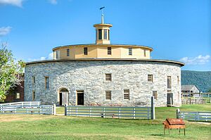
The Round Barn at Hancock Shaker Village
|
|||
|
|||

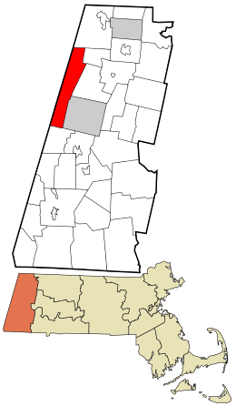
Location in Berkshire County and the state of Massachusetts.
|
|||
| Country | United States | ||
| State | Massachusetts | ||
| County | Berkshire | ||
| Settled | 1767 | ||
| Incorporated | 1776 | ||
| Government | |||
| • Type | Open town meeting | ||
| Area | |||
| • Total | 35.8 sq mi (92.6 km2) | ||
| • Land | 35.7 sq mi (92.4 km2) | ||
| • Water | 0.08 sq mi (0.2 km2) | ||
| Elevation | 1,058 ft (322 m) | ||
| Population
(2020)
|
|||
| • Total | 757 | ||
| • Density | 21.173/sq mi (8.175/km2) | ||
| Time zone | UTC-5 (Eastern) | ||
| • Summer (DST) | UTC-4 (Eastern) | ||
| ZIP code |
01237 (Lanesborough), 01267 (Williamstown), 01201 (Pittsfield)
|
||
| Area code(s) | 413 | ||
| FIPS code | 25-28180 | ||
| GNIS feature ID | 0619421 | ||
| Website | town.hancock.ma.us | ||
Hancock is a small and peaceful town located in Berkshire County, Massachusetts, United States. It is part of the larger Pittsfield area. In 2020, about 757 people lived here.
Contents
History of Hancock
Hancock was first settled in 1762. Back then, it was known as the Plantation of Jericho.
The town officially became a town in 1776. This was the same year the United States declared its independence! It was renamed Hancock after John Hancock, a famous American patriot.
Hancock Shaker Village: A Unique Community
Around 1780, some families in Hancock became followers of the Shakers. By 1790, these believers started a community called Hancock Shaker Village.
The Shakers were a special religious order. They believed in pacifism, which means they were against all war and violence. They also believed in living a simple life, being celibate (not marrying or having children), and sharing everything in a communal way.
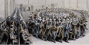
Their worship often included singing and energetic dancing. This is why people sometimes called them the "Shaking Quakers" or "Shakers." Today, the Shakers are well-known for their simple and beautiful furniture and buildings.
Hancock Shaker Village is especially famous for its Round Stone Barn. This unique barn was built in 1826. In 1959, the remaining Shakers sold the property. It is now a non-profit museum where visitors can learn about their history and way of life.
Geography of Hancock
Hancock covers an area of about 92.6 square kilometers (35.8 square miles). Most of this area is land, with only a small part being water.
The town is surrounded by other towns and even a state! To the north is Williamstown. To the east are Lanesborough and Pittsfield. To the south is Richmond. On its western side, Hancock borders towns in New York state, like Canaan and New Lebanon.
Mountains and Rivers
Much of northern Hancock is in a valley. This valley is surrounded by the Taconic Mountains. Rivers flow through this area. The Green River flows north, and the Kinderhook Creek flows southwest.
You can find several mountains here. On the western side, near the New York border, are peaks like Misery Mountain. To the northeast, you'll find mountains like Brodie Mountain and Jiminy Peak. Jiminy Peak is home to a popular ski area where people enjoy winter sports!
Southern Hancock, where the Shaker Village is, also has many Taconic peaks. These include Tower Mountain and Shaker Mountain.
One interesting spot is Berry Pond. It's the highest body of water in Massachusetts, sitting over 630 meters (2,067 feet) above sea level! The highest point in Hancock itself is a part of Misery Mountain, reaching 814 meters (2,671 feet) high.
Roads and Transportation
U.S. Route 20 goes through the southern part of Hancock. Massachusetts Route 43 is another important road that runs through the town.
Hancock does not have its own train, bus, or airport services. The closest places to find these are in nearby cities like Pittsfield, Williamstown, and North Adams. If you need to fly to other states, the nearest major airport is Albany International Airport in New York, which is about 40 miles (64 km) away.
Population of Hancock
| Historical population | ||
|---|---|---|
| Year | Pop. | ±% |
| 1850 | 789 | — |
| 1860 | 816 | +3.4% |
| 1870 | 882 | +8.1% |
| 1880 | 642 | −27.2% |
| 1890 | 506 | −21.2% |
| 1900 | 451 | −10.9% |
| 1910 | 465 | +3.1% |
| 1920 | 464 | −0.2% |
| 1930 | 361 | −22.2% |
| 1940 | 332 | −8.0% |
| 1950 | 445 | +34.0% |
| 1960 | 455 | +2.2% |
| 1970 | 675 | +48.4% |
| 1980 | 643 | −4.7% |
| 1990 | 628 | −2.3% |
| 2000 | 721 | +14.8% |
| 2010 | 717 | −0.6% |
| 2020 | 757 | +5.6% |
| 2022* | 746 | −1.5% |
| * = population estimate. Source: United States Census records and Population Estimates Program data. |
||
As of 2020, Hancock had a population of 757 people. This makes it one of the smaller towns in Berkshire County.
In 2000, there were 721 people living in Hancock. About 29.7% of the households had children under 18. Most people living in Hancock were White, with small percentages of other racial backgrounds. The average age of people in Hancock was 40 years old.
Education in Hancock
Hancock has one school called Hancock Elementary School. It teaches students from kindergarten up to sixth grade.
After sixth grade, students from Hancock go to Mount Greylock Regional High School. This high school is located in the nearby town of Williamstown.
For higher education, the closest community college is Berkshire Community College in Pittsfield. There are also state colleges nearby, like Westfield State University and Massachusetts College of Liberal Arts. Williams College in Williamstown is the closest private college.
See also
 In Spanish: Hancock (Massachusetts) para niños
 | Anna J. Cooper |
 | Mary McLeod Bethune |
 | Lillie Mae Bradford |


