County of Adelaide facts for kids
Quick facts for kids AdelaideSouth Australia |
|||||||||||||||
|---|---|---|---|---|---|---|---|---|---|---|---|---|---|---|---|

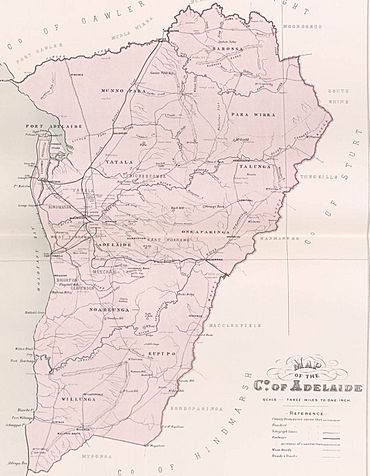
Map of Adelaide County in 1886 showing the hundreds
|
|||||||||||||||
| Established | 2 June 1842 | ||||||||||||||
| Area | 2,960 square kilometres (1,141 sq mi) | ||||||||||||||
|
|||||||||||||||
| Footnotes | Adjoining counties | ||||||||||||||
The County of Adelaide is a special area of land in South Australia. It's one of 49 "cadastral counties," which are like old-fashioned land divisions used for mapping and managing land. This county is very important because it contains the big city of Adelaide.
It was officially created on June 2, 1842, by Governor Grey. For a long time, between 1855 and 1921, most of South Australia's population lived in the County of Adelaide. In fact, by 1966, over 70% of the state's people lived here!
Where is the County of Adelaide?
The County of Adelaide is located in a key part of South Australia. Its northern border is marked by the Gawler River and the North Para River. To the east, you'll find the beautiful Mount Lofty Ranges. On its western side, it meets the Gulf St Vincent, which is part of the ocean.
The southern border stretches from Aldinga Bay on the coast, goes through Willunga South, and reaches Mount Magnificent.
What are "Hundreds"?
Counties like Adelaide are divided into smaller areas called "hundreds." Think of them like smaller districts or neighborhoods within the larger county. The County of Adelaide is split into several of these hundreds, each with its own name and location. They are generally listed from the north-west to the south-east.
Here are the hundreds within the County of Adelaide:
- Hundred of Port Adelaide: This hundred is in the north-west, right next to Gulf St Vincent. It's located between the Gawler River and Grand Junction Road.
- Hundred of Barossa: You'll find this one in the north, stretching across the Barossa Range.
- Hundred of Munno Para: Also in the north, this hundred sits between the Gawler and Little Para rivers.
- Hundred of Para Wirra: This hundred is in the north-east, just south of the South Para River.
- Hundred of Yatala: Located beside Gulf St Vincent, this area is between the Little Para and Torrens rivers.
- Hundred of Talunga: In the east, this hundred covers the Torrens Valley within the Adelaide Hills.
- Hundred of Adelaide: This hundred is in the west, next to Gulf St Vincent and south of the Torrens River.
- Hundred of Onkaparinga: Found in the east, this hundred spans the Onkaparinga Valley in the Adelaide Hills.
- Hundred of Noarlunga: In the south-west, this hundred is beside Gulf St Vincent. It's located between the Sturt and Onkaparinga rivers.
- Hundred of Willunga: This hundred is in the south, also next to Gulf St Vincent, and immediately south of the Onkaparinga River.
- Hundred of Kuitpo: In the south-east, this hundred stretches across the Adelaide Hills. It goes from the upper Onkaparinga River and the South Eastern Freeway all the way to Mount Magnificent.
 | Janet Taylor Pickett |
 | Synthia Saint James |
 | Howardena Pindell |
 | Faith Ringgold |

