Alexander County, North Carolina facts for kids
Quick facts for kids
Alexander County
|
|||
|---|---|---|---|
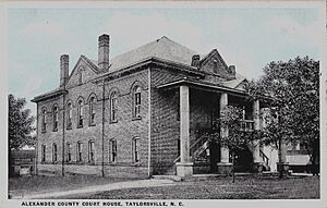
Alexander County Courthouse
|
|||
|
|||
| Motto(s):
"A wonderful place to live, work and play."
|
|||
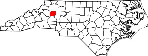
Location within the U.S. state of North Carolina
|
|||
 North Carolina's location within the U.S. |
|||
| Country | |||
| State | |||
| Founded | 1847 | ||
| Named for | William Julius Alexander | ||
| Seat | Taylorsville | ||
| Largest community | Bethlehem | ||
| Area | |||
| • Total | 263.64 sq mi (682.8 km2) | ||
| • Land | 259.99 sq mi (673.4 km2) | ||
| • Water | 3.65 sq mi (9.5 km2) 1.39% | ||
| Population
(2020)
|
|||
| • Total | 36,444 | ||
| • Estimate
(2023)
|
36,473 | ||
| • Density | 140.17/sq mi (54.12/km2) | ||
| Time zone | UTC−5 (Eastern) | ||
| • Summer (DST) | UTC−4 (EDT) | ||
| Congressional district | 10th | ||
Alexander County is a county in the state of North Carolina, USA. It was created in 1847. In 2020, about 36,444 people lived there. The main town and county seat is Taylorsville. Alexander County is part of the larger Hickory-Lenoir-Morganton area.
Contents
History of Alexander County
How Alexander County Was Formed
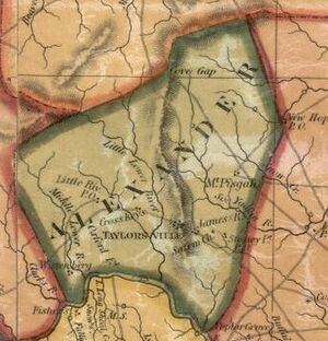
Alexander County was created in 1847. It was made from parts of three other counties: Iredell County, Caldwell County, and Wilkes County.
The county was named after William Julius Alexander. He was an important leader in the North Carolina General Assembly, serving as the Speaker of the North Carolina House of Commons. Many of the first settlers in this area were farmers. They came from Scots-Irish and German backgrounds.
Two laws passed in January 1847 officially created Alexander County. These laws said the county would start once Caldwell County had at least 5,000 people. The first land sales in the county seat, Taylorsville, happened in August 1847. Taylorsville was named after either John Louis Taylor, a local farmer and thinker, or General Zachary Taylor, who later became the twelfth president of the United States. The money from these land sales helped build the first courthouse in Taylorsville.
Alexander County During the Civil War
When the American Civil War started in 1861, Alexander County was only 14 years old. During the war, in 1865, soldiers led by Major General George Stoneman raided Taylorsville. They destroyed many of the county's important court records.
The Alexander Railroad
The Alexander Railroad started in 1946. It connects Taylorsville to Statesville. This short train line helps move goods and connects to the larger Norfolk Southern system.
Geography of Alexander County
Alexander County covers about 263.64 square miles. Most of this is land (about 259.99 square miles), and a small part is water (about 3.65 square miles).
Mountains and Rivers
Alexander County is in the "Foothills" area of western North Carolina. The most important natural feature here is the Brushy Mountains. These mountains are like a smaller branch of the Blue Ridge Mountains. They rise up to 1,000 feet above the land around them. The highest point in Alexander County is Hickory Knob, which is 2,560 feet above sea level. Another mountain, Barrett Mountain, is in the western part of the county. The rest of the county has gently rolling hills. The biggest river in the county, the Catawba, forms its southern border.
Hiddenite Mine
In Alexander County, there's a town called Hiddenite. This town is famous for its mine. Here, people find beautiful emeralds, sapphires, and a special stone called "hiddenite." Hiddenite is a type of mineral called spodumene.
Transportation in Alexander County
The county has several important roads, including US Highway 64. This highway connects Taylorsville to Lenoir and Statesville. Other state highways like NC 90, 16, and 127 also serve the area. Larger highways like Interstate 40 and 77 are about 30 minutes away. For air travel, the Charlotte Douglas International Airport is about an hour's drive. There are also smaller airports closer by, like Hickory Regional Airport (30 minutes) and Statesville Airport (20 minutes). The Alexander Railroad also helps transport goods.
Protected Areas
- Rocky Face Mountain Recreational Area
Major Water Bodies
- Catawba River
- Cub Creek
- Duck Creek
- Elk Shoals Creek
- Grassy Creek
- Lake Hickory
- Lookout Shoals Lake
- Lower Little River
- Middle Little River
- Mill Creek
- Rink Lake
- Rock Creek
- Rocky Creek
- Shuford Pond
- Snow Creek
- South Yadkin River
- Spring Creek
- Third Creek
- Wallace Creek
- White Creek
Nearby Counties
Alexander County shares its borders with these counties:
- Wilkes County – to the north
- Iredell County – to the east
- Catawba County – to the south
- Caldwell County – to the west
Main Roads
 US 64
US 64 NC 16
NC 16
 NC 16 Truck (truck route)
 NC 90
NC 90 NC 127
Important Infrastructure
- The county is served by the Alexander Railroad Company.
People in Alexander County (Demographics)
| Historical population | |||
|---|---|---|---|
| Census | Pop. | %± | |
| 1850 | 5,220 | — | |
| 1860 | 6,022 | 15.4% | |
| 1870 | 6,868 | 14.0% | |
| 1880 | 8,355 | 21.7% | |
| 1890 | 9,430 | 12.9% | |
| 1900 | 10,960 | 16.2% | |
| 1910 | 11,592 | 5.8% | |
| 1920 | 12,212 | 5.3% | |
| 1930 | 12,922 | 5.8% | |
| 1940 | 13,454 | 4.1% | |
| 1950 | 14,554 | 8.2% | |
| 1960 | 15,625 | 7.4% | |
| 1970 | 19,466 | 24.6% | |
| 1980 | 24,999 | 28.4% | |
| 1990 | 27,544 | 10.2% | |
| 2000 | 33,603 | 22.0% | |
| 2010 | 37,198 | 10.7% | |
| 2020 | 36,444 | −2.0% | |
| 2023 (est.) | 36,473 | −1.9% | |
| U.S. Decennial Census 1790–1960 1900–1990 1990–2000 2010 2020 |
|||
2020 Census Information
Here's a look at the different groups of people living in Alexander County, based on the 2020 census:
| Race | Number | Percentage |
|---|---|---|
| White (non-Hispanic) | 30,893 | 84.77% |
| Black or African American (non-Hispanic) | 1,919 | 5.27% |
| Native American | 111 | 0.3% |
| Asian | 390 | 1.07% |
| Pacific Islander | 1 | 0.0% |
| Other/Mixed | 1,294 | 3.55% |
| Hispanic or Latino | 1,836 | 5.04% |
In 2020, there were 36,444 people living in Alexander County. These people lived in 14,169 households, which included 10,232 families.
Communities in Alexander County
Towns
- Taylorsville (This is the county seat, meaning it's where the county government is located. It has been the county seat since 1847.)
Townships
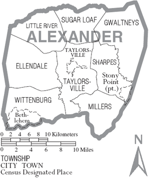
In North Carolina, counties are divided into smaller areas called townships. Alexander County has eight townships:
- Ellendale
- Gwaltneys
- Little River
- Millers
- Sharpes
- Sugar Loaf
- Taylorsville
- Wittenburg
Census-Designated Places (CDPs)
These are areas that are like towns but are not officially incorporated as cities or towns.
- Bethlehem (This is the largest community in the county.)
- Hiddenite
- Stony Point
Unincorporated Communities
These are smaller communities that are not officially part of a town or city.
- Drumstand
- Ellendale
- Little River
- Millersville
- Sugar Loaf
- Vashti
- Wittenburg
Community Population Ranking
Here's how the main communities in Alexander County rank by population, based on the 2020 census:
† = county seat
| Rank | Name | Type | Population (2020 census) |
|---|---|---|---|
| 1 | Bethlehem | CDP | 4,491 |
| 2 | † Taylorsville | Town | 2,320 |
| 3 | Stony Point | CDP | 1,146 |
| 4 | Hiddenite | CDP | 507 |
See also
 In Spanish: Condado de Alexander (Carolina del Norte) para niños


