
Angelino Dulcert facts for kids
Angelino Dulcert (who was active around 1339) was likely the same person known as Angelino de Dalorto (active in the 1320s). His real name might have been Angelino de Dulceto or Dulceti, or even Angelí Dolcet. He was an Italian mapmaker who lived in Majorca.
He created two important maps in the 1300s: the "Dalorto" map from 1325 and the "Dulcert" map from 1339. The 1339 "Dulcert" map was the first of its kind made in Palma, Majorca. It is seen as the starting point for the famous Majorcan cartographic school of mapmaking. People also believe he made a third map, which is not dated or signed, and is kept in London.
Contents
Who Was Angelino Dulcert?
We don't know much about Angelino Dulcert, Dalorto, or Dulceti. Most people think he was an Italian from a region called Liguria. He probably learned how to make maps in Genoa, a big city in Italy. Later, he moved to Majorca sometime between the 1320s and 1330s.
His name can be a bit confusing because he signed his maps in different ways. Some scholars thought "Dalorto" was his original name and "Dulcert" was a more local, Catalan-sounding name he used in Majorca. However, newer studies suggest that both names, "Dalorto" and "Dulcert," might actually come from a small Italian town called Dulcedo in Liguria. This supports the idea that he was an Italian who moved to Majorca.
What's most important for map history is where he learned his skills and where he worked. The details on his maps show that he learned mapmaking in Genoa.
The Dalorto 1325 Map
.jpg)
Angelino "Dalorto" is known for a special type of map called a portolan chart. These maps were used by sailors in the Middle Ages. This map is usually dated to 1325, but some experts now think it was made around 1330. It is privately owned by the Corsini family in Florence, Italy.
The 1325 Dalorto map was a turning point in European mapmaking. It combined the simple, coast-focused style of Italian maps with new ideas. Earlier Italian maps, like those by Pietro Vesconte, mostly showed coastlines. But Dalorto's map started to add more details inland, such as small pictures of cities, mountains, and rivers. This idea of adding inland details became very popular in the later Majorcan mapmaking style. For example, the map shows the Red Sea colored red, the Atlas Mountains shaped like a palm tree, and the Alps like a chicken's foot.
This map also improved our knowledge of geography. It showed a better picture of northern Europe, especially the Baltic Sea, than maps before it.
The Dalorto map was also the first to show a legendary island called Brasil. It was drawn as a circular island southwest of Ireland. The map's caption for it said, "Isle of sheep (?) or of brasil."
The Dulcert 1339 Map

Angelino "Dulcert" is famous for a portolan chart made in 1339. This map is kept at the Bibliotheque Nationale de France in Paris. The map's signature says: "In August of the year 1339, Angelino Dulcert made this in the city of Majorca." Unlike his earlier map, this one was made on two pieces of parchment (animal skin) joined together, measuring about 75 by 102 centimeters.
Because it was made in Palma, the Dulcert 1339 map is considered the founding piece of the Majorcan cartographic school. While some of its features were already seen in the Dalorto map, this one went even further with inland illustrations. It even included small pictures of people!
The 1339 Dulcert map is quite similar to the 1325 Dalorto map in many ways. However, its labels and descriptions are written in Latin. It also has features not usually found on maps from Genoa or Venice.
This map is important for showing the first modern picture of Lanzarote, one of the Canary Islands. It's labeled as Insula de Lanzarotus Marocelus, which refers to a Genoese sailor named Lancelotto Malocello. The map also puts a Genoese shield on the island, a custom that other mapmakers would later copy.
Dulcert's map also seems to show the Madeira islands. He named them Capraria and Canaria, which were old names for two of the legendary Fortunate Islands from ancient times.
The oldest known flag or symbol connected to Macedonia is found on the Dulcert 1339 Map. It shows the banner of Skopje with a red double-headed eagle on a gold background. Above the city name "Scopi" (Skopje), it says "Servia" (Serbia).
-
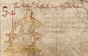
Özbeg Khan, ruler of the Golden Horde, on the 1339 Dulcert map. The text says: Hic dominatur Usbech, dominus imperator de Sara, meaning "Here rules Özbeg, the Emperor of Sara".
-
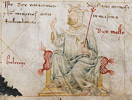
Mansa Moussa, ruler of the Mali Empire, on the map of Angelino Dulcert.
-

The Queen of Saba, from the Kingdom of Saba.


The London Map (around 1340)
In the 20th century, a third map was found. It doesn't have a signature, but many experts believe Angelino Dulcert made it because of its style and features. This map is kept at the British Library in London, UK. It is thought to have been made around the 1340s, though some scholars believe it might even be older than the 1325 Dalorto map.
See Also
 In Spanish: Angelino Dulcert para niños
- Rhumbline network
- Majorcan cartographic school
