Antares, Arizona facts for kids
Quick facts for kids
Antares, Arizona
|
|
|---|---|
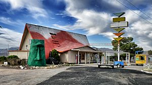
Tourist attractions in 2011
|
|
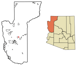
Location in Arizona
|
|
| Country | United States |
| State | Arizona |
| County | Mohave |
| Area | |
| • Total | 0.65 sq mi (1.7 km2) |
| • Land | 0.65 sq mi (1.7 km2) |
| • Water | 0 sq mi (0 km2) |
| Elevation | 3,498 ft (1,066 m) |
| Population
(2020)
|
|
| • Total | 132 |
| • Density | 203.1/sq mi (78.4/km2) |
| Time zone | UTC−07:00 (Mountain Standard Time) |
| ZIP code |
86401
|
| Area code(s) | 928 |
| GNIS feature ID | 2582728 |
Antares is a small community in Mohave County, Arizona, United States. It is an "unincorporated community" and a "census-designated place" (CDP). This means it's a recognized area for counting people, but it doesn't have its own city government.
In 2020, about 132 people lived there. Antares is located along a famous old road called Historic Route 66.
Contents
What's in a Name?
Antares gets its name from a bright red supergiant star called Antares. This star is part of the Scorpio constellation. The word "Antares" comes from Greek and means "rival of Mars." The star was given this name because it has a strong red color, much like the planet Mars.
A Look Back: Antares's History
Antares started as a simple stop for trains. In 1883, the Atlantic and Pacific Railroad was building tracks. They had to go around the Peacock Mountains. This led them to build a curve in the tracks where Antares is now.
Later, in 1910, the National Old Trails Highway was built. It followed the railroad tracks. Then, in 1926, the famous Route 66 was also built next to the railroad. This made Antares a recognized "town and railroad station" by 1923.
The area around Antares also has a history of mining. People looked for valuable metals like copper, gold, lead, and silver there. Many old mining claims are now closed.
Where is Antares?
Antares is in the northwestern part of Arizona. It's about 21 miles (34 km) northeast of Kingman, which is the main city of Mohave County. The community covers about 0.65 square miles (1.68 sq km) of land. It sits at an elevation of about 3,556 feet (1,084 meters) above sea level.
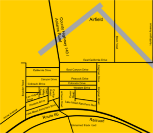
The southern edge of Antares follows State Route 66, which is the old U.S. Route 66. The community has a few main roads like Antares Road, Kingman Road, Boulder Road, and California Drive. Most buildings are west of Antares Road.
Who Lives in Antares?
| Historical population | |||
|---|---|---|---|
| Census | Pop. | %± | |
| 2010 | 126 | — | |
| 2020 | 132 | 4.8% | |
| U.S. Decennial Census | |||
Antares was first counted as a CDP in the 2010 U.S. Census. In 2010, there were 126 residents. About half were male and half were female. The average age of people living there was around 64 years old. Most residents were White American, with a small number of Native Americans.
By 2020, the population had grown slightly to 132 people.
What's the Weather Like?
| Climate data for Truxton Canyon (Antares CDP), Arizona | |||||||||||||
|---|---|---|---|---|---|---|---|---|---|---|---|---|---|
| Month | Jan | Feb | Mar | Apr | May | Jun | Jul | Aug | Sep | Oct | Nov | Dec | Year |
| Mean daily maximum °F (°C) | 53.5 (11.9) |
58.5 (14.7) |
64.2 (17.9) |
72.0 (22.2) |
81.1 (27.3) |
91.7 (33.2) |
96.4 (35.8) |
93.9 (34.4) |
87.8 (31.0) |
77.7 (25.4) |
65.4 (18.6) |
55.5 (13.1) |
74.8 (23.8) |
| Mean daily minimum °F (°C) | 27.4 (−2.6) |
30.3 (−0.9) |
33.8 (1.0) |
39.5 (4.2) |
46.9 (8.3) |
55.3 (12.9) |
64.0 (17.8) |
62.3 (16.8) |
55.5 (13.1) |
44.7 (7.1) |
34.2 (1.2) |
28.1 (−2.2) |
43.5 (6.4) |
| Average precipitation inches (mm) | 1.05 (27) |
1.07 (27) |
0.97 (25) |
0.69 (18) |
0.29 (7.4) |
0.21 (5.3) |
1.27 (32) |
1.97 (50) |
1.13 (29) |
0.70 (18) |
0.56 (14) |
1.00 (25) |
10.91 (277.7) |
| Average snowfall inches (cm) | 1.1 (2.8) |
0.6 (1.5) |
0.5 (1.3) |
0.1 (0.25) |
0.0 (0.0) |
0.0 (0.0) |
0.0 (0.0) |
0.0 (0.0) |
0.0 (0.0) |
0.0 (0.0) |
0.2 (0.51) |
1.7 (4.3) |
4.2 (10.66) |
| Source: WRCC | |||||||||||||
Getting Around Antares
Roads and Trains
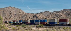
The main road in Antares is Route 66. The BNSF Railway train tracks run right next to Route 66.
There's also an unpaved road called Antares Road. It's a county road that goes north through the Hualapai Valley. This road connects to Pierce Ferry Road, which can take you to Meadview and Lake Mead on the Colorado River.
The part of Route 66 that goes through Antares is a long curve. This curve, known as "Antares Point," is special because it's the longest continuous curve on any United States Highway, stretching for about 2 miles (3.2 km)!
Airports Nearby
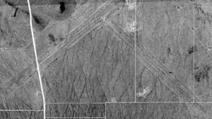
Antares has a local airport called Music Mountain Air Ranch. It has two dirt runways. This airport used to be called Kingman Number 3 Army Airfield during World War II.
For bigger flights, the closest commercial airport is Kingman Airport, about 15 miles (24 km) west of Antares. Laughlin/Bullhead International Airport in Bullhead City is also relatively close. For major international flights, you'd go to Phoenix Sky Harbor International Airport in Phoenix or Harry Reid International Airport in Las Vegas.
Community Services
The Valle Vista District Fire Station #2 is located on Antares Road, just north of Route 66. This station helps keep the community safe. Some electrical services for the nearby Hualapai Indian reservation are also connected through Antares Road.
What to See in Antares
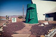
A popular spot in Antares is a camp park known as Kozy Corner RV park and Ranchero Motel. This place is famous for its unique attraction: "Giganticus Headicus." It's a huge, homemade monument that looks like the famous Easter Island heads, standing about 14 feet (4.3 meters) tall! The park is right on the "Antares Point" curve of Route 66.
The RV park started as a camp for railroad workers many years ago. There's even a local story that Gene Roddenberry, the creator of Star Trek, once stayed at the motel. The legend says he named the Antares spaceship in Star Trek after this very location!
See also
 In Spanish: Antares (Arizona) para niños


