
Bald Head Island, North Carolina facts for kids
Quick facts for kids
Bald Head Island
|
||
|---|---|---|
|
Village
|
||

Bald Head Island Marina with Old Baldy lighthouse
|
||
|
||
| Nickname(s):
Old Baldy
|
||

Bald Head Island
Location in North Carolina
|
||
| Country | United States | |
| State | North Carolina | |
| County | Brunswick | |
| Township | Smithville Township | |
| Founded | 1817 | |
| Area | ||
| • Total | 5.86 sq mi (15.18 km2) | |
| • Land | 3.91 sq mi (10.14 km2) | |
| • Water | 1.95 sq mi (5.04 km2) | |
| Elevation | 0 ft (0 m) | |
| Population
(2020)
|
||
| • Total | 268 | |
| • Density | 68.47/sq mi (26.43/km2) | |
| Time zone | UTC-5 (EST) | |
| • Summer (DST) | UTC-4 (EDT) | |
| ZIP code |
28461
|
|
| Area codes | 910, 472 | |
| FIPS code | 37-03150 | |
| GNIS feature ID | 2407414 | |

Bald Head Island, once called Smith Island, is a small village in Brunswick County, North Carolina, United States. It is located on the east side of the Cape Fear River. Unlike bigger cities nearby, Bald Head Island is quiet and a bit isolated.
You can reach the island by ferry from the town of Southport. Only government workers can drive special four-wheel drive vehicles along the beach from Fort Fisher. Most people on the island use electric golf carts instead of cars.
Bald Head Island is famous for its sea turtles that come to nest on its beaches. In 2020, about 268 people lived in the village. It is a popular place for vacations because of its beautiful scenery. The island is also home to "Old Baldy", a lighthouse built in 1817. It is the oldest lighthouse still standing in North Carolina.
Contents
Island History: From Forts to Fun
Bald Head Island is small, but it has played a part in two important American wars.
Early Days and Changing Names
The island is at the very tip of Cape Fear. Here, the Cape Fear River meets the Atlantic Ocean. This area has tricky sand bars called Frying Pan Shoals. These sand bars can appear and disappear quickly. Scientists believe Bald Head Island itself grew from one of these sand bars.
Long ago, Native Americans likely used Bald Head Island as a seasonal retreat. They probably came to fish and gather shellfish. Evidence of their visits, like shell mounds, has been found on nearby islands.
Over time, European explorers tried to settle the Cape Fear region. Spanish sailors visited in the 1520s. Later, English explorers like William Hilton tried to start colonies in the 1660s. These early attempts failed because the sandy soil was hard to farm.
In 1664, John Vassal tried to found "Charles Town" on the west bank of the Cape Fear River. This also failed due to conflicts with Native Americans. Later, a successful Charles Town was established further south, which is now Charleston, South Carolina.
Revolutionary War Role
In 1776, during the Revolutionary War, British generals used Bald Head Island. They used it as a meeting point before heading to Charleston, South Carolina. The British left a small group of soldiers, about 30, to guard the port. They built a fort called Fort George on the island.
American soldiers, led by Colonel Polk, attacked Fort George. They captured some British sailors but had to retreat when more British soldiers and ships fought back. By October, the British left, and Bald Head Island saw no more fighting in the Revolution.
Civil War Importance
During the Civil War, the same fort area became Fort Holmes. This was an important base for the Confederate side. It helped with shipping and smuggling goods.
Lighthouses: Guiding Ships Safely
Lighthouses are tall towers with bright lights. They help ships find their way and avoid dangerous areas. Bald Head Island has a rich history with lighthouses.
The First Lighthouse
In 1789, people decided to build a lighthouse at the mouth of the Cape Fear River. The goal was to help ships avoid the dangerous Frying Pan Shoals. Funds were raised by taxing ships entering the port. The U.S. Congress also helped pay for it.
The first lighthouse was finished in 1794. However, it was built too close to the water. By 1813, less than 20 years later, the lighthouse was falling apart due to erosion.
Old Baldy: A Lasting Landmark

In 1813, Congress approved money to build a new lighthouse. This time, they planned to build it on higher, safer ground. The new lighthouse, known as Old Baldy Light, was finished in 1817.
However, Old Baldy was not tall or bright enough to guide ships around the Frying Pan Shoals. It mostly helped ships enter the Cape Fear River. Many ships chose to use a different entrance, New Inlet, further north. Because of this, Old Baldy was not well maintained.
Old Baldy was turned off during the Civil War to make it harder for Union ships to navigate. After the war, it stayed off because it was in bad shape.
But in 1879, New Inlet closed naturally. This meant ships had to use the Cape Fear River entrance again. So, Old Baldy was lit up once more. Improvements were made, including a new light and a stone jetty to protect the shore. This jetty helped save Old Baldy from a hurricane in 1883.
Old Baldy stopped being a lighthouse in 1935 and became a radio beacon. It was fully turned off in 1959 when the Oak Island Light was built. Today, Old Baldy is the oldest lighthouse in North Carolina. It is a historic site and open to visitors.
Cape Fear Light: A Brighter Beacon
Old Baldy wasn't powerful enough for the Frying Pan Shoals. So, a lightship was placed on the shoals. But this ship sometimes broke loose, leaving the shoals without a light.
People wanted a taller, brighter lighthouse. In 1889, they suggested a new 150-foot tall tower. Construction began in 1901, and the Cape Fear Light started working on August 31, 1903. This light was much stronger and helped guide ships around the dangerous shoals.
In 1958, the Cape Fear Light was taken down. The Oak Island Light replaced it. Other lightships and a light tower continued to help guide ships around Frying Pan Shoals until the 1970s.
Nature: Living with Wildlife
Bald Head Island is known as a place where people live in harmony with nature. Strict rules help protect the island's environment.
Protecting the Environment
The Bald Head Island Conservancy works hard to protect the island's water quality, dunes, forests, and salt marshes. They even work with the USGS to monitor water quality.
The Conservancy also partners with other groups to manage the island's deer population in a safe way. They are also installing a weather station with NC State University. This will help them understand weather patterns and make good decisions for the island.
Island Habitats
The island has four main natural areas:
- Beaches and dunes
- Maritime forest (forest near the sea)
- Freshwater lagoons
- Salt marsh and estuary (where fresh and salt water mix)
You can find trees like live oak, cabbage palmetto, and longleaf pine in the forests.
Birdwatching Paradise
Bald Head Island is a fantastic place for birdwatching all year round. More than 260 types of birds have been seen here! Some common birds include the white ibis, osprey, snowy egret, great blue heron, brown pelican, and even the bald eagle. The Bald Head Island Conservancy offers guided birdwatching trips.
Researchers also visit every summer to study and tag painted buntings, which are colorful birds.
Sea Turtle Haven
Bald Head Island is famous for its sea turtle nesting. Visitors often say, "I'm on Turtle Time," meaning they feel relaxed and carefree, just like the island's car-free lifestyle.
Efforts to protect sea turtles started in 1980. Since 1983, the Bald Head Island Conservancy has run a sea turtle protection program. They are the only non-government group in North Carolina allowed to tag nesting sea turtles. Each summer, interns work with a sea turtle biologist to help with this program.
Only three of the seven types of sea turtles nest on Bald Head Island:
- Loggerhead turtles are the most common.
- A few green turtles visit each season.
- In 2010, a leatherback turtle laid its first nest here.
Visitors can join the Conservancy's Sea Turtle Protection Staff for a nightly Turtle Walk. You can learn about sea turtles and then go to the beach to watch for nesting or hatching turtles.
Island Geography
Bald Head Island is located in southeastern Brunswick County. It is the southernmost settlement in North Carolina.
The village covers about 14.9 square kilometers (5.8 square miles). About 10.0 square kilometers (3.9 square miles) is land, and the rest is water.
After Hurricane Bonnie in 1998, Bald Head Island became connected to the Fort Fisher State Recreation Area by a sand shoal. Even though they are connected, they still keep their original names.
The island has three main beaches, and its north side is mostly marshland.
Population and Climate
Island Population
Bald Head Island is a small community. Here's how its population has changed over the years:
| Historical population | |||
|---|---|---|---|
| Census | Pop. | %± | |
| 1990 | 78 | — | |
| 2000 | 173 | 121.8% | |
| 2010 | 158 | −8.7% | |
| 2020 | 268 | 69.6% | |
| U.S. Decennial Census | |||
In 2020, there were 268 people living in the village. Most residents were White (90.67%), with smaller percentages of Black or African American, Asian, and other races. About 3.36% of the population was Hispanic or Latino.
Weather on the Island
Bald Head Island has a humid subtropical climate. This means it has hot, humid summers and cool winters.
| Climate data for Bald Head Island, North Carolina | |||||||||||||
|---|---|---|---|---|---|---|---|---|---|---|---|---|---|
| Month | Jan | Feb | Mar | Apr | May | Jun | Jul | Aug | Sep | Oct | Nov | Dec | Year |
| Mean daily maximum °F (°C) | 55 (13) |
57 (14) |
64 (18) |
72 (22) |
79 (26) |
84 (29) |
88 (31) |
88 (31) |
84 (29) |
75 (24) |
68 (20) |
61 (16) |
73 (23) |
| Mean daily minimum °F (°C) | 34 (1) |
36 (2) |
43 (6) |
48 (9) |
57 (14) |
64 (18) |
70 (21) |
70 (21) |
63 (17) |
52 (11) |
43 (6) |
36 (2) |
52 (11) |
| Average precipitation inches (mm) | 5.3 (134) |
4.2 (106) |
4.5 (114) |
3.1 (78) |
4.1 (105) |
5.0 (128) |
6.7 (170) |
7.7 (195) |
8.9 (227) |
3.9 (98) |
3.5 (88) |
4.2 (106) |
61.0 (1,549) |
| Source: The Weather Channel | |||||||||||||
Images for kids
-
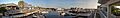
The marina at Bald Head Island.
-
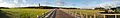
A wide view of the marshlands on Bald Head Island.
See also
 In Spanish: Bald Head Island para niños
