
Bankside Pier facts for kids

The gangway at Bankside Pier
|
|
| Locale | River Thames, London, UK |
|---|---|
| Owner | London River Services |
| Operator | London River Services |
| Coordinates | 51°30′31″N 0°05′47″W / 51.508553°N 0.096340°W |

Location in City of London
|
|
Bankside Pier is a busy stop for boats on the River Thames in London, UK. It's located on the south side of the river. This pier is super close to the famous Tate Modern art museum. It's also near Shakespeare's Globe, a theatre that looks just like the one Shakespeare used to perform in!
Many different boat services use Bankside Pier. These include river bus routes like RB1 and RB2. The RB1 route connects areas like Embankment and Woolwich Arsenal. The RB2 route travels to places like St George Wharf Pier. There's also a special boat tour called the Circular Cruise Westminster. This cruise takes you on a fun trip to Westminster and St Katherine's.
Getting to Bankside Pier by Public Transport
Bankside Pier is easy to reach using London's public transport system.
Underground Stations Near Bankside Pier
You can get to the pier by using the London Underground, also known as the "Tube."
- Southwark Underground station is on the Jubilee line. It's a short walk from the pier.
- Blackfriars Underground station is on the Circle and District lines. This station is on the north side of the River Thames. You can walk across Blackfriars Bridge to reach the pier.
Images for kids
-
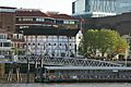
The pier with Shakespeare's Globe theatre in the background.
-
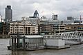
A view of Bankside Pier from the South Bank walkway.
-
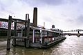
A boat leaving Bankside Pier, heading down the River Thames.


| Preceding station | London River Services | Following station | ||
|---|---|---|---|---|
|
toward Embankment Pier
|
Commuter Service |
toward Woolwich Arsenal Pier
|
||
|
toward Millbank Millennium Pier
|
Tate to Tate | Terminus | ||
|
toward Westminster Millennium Pier
|
Westminster to St Katharine's Circular |
toward Westminster Millennium Pier
|
<mapframe text="![]() Map of Thames piers in London
Map of Thames piers in London ![]() = TfL piers
= TfL piers ![]() = Other operators' piers"
= Other operators' piers"
latitude="51.4854" longitude="-0.121193" zoom="12" width="850" height="300" align="center"> { "type": "FeatureCollection", "features": [
/* ============ unusual ================== */
{ "type": "Feature", "properties": { "title": "![]() Tower Lifeboat Station
Tower Lifeboat Station ![]() " ,
" ,
"description": "

",
"marker-symbol": "london-underground", "marker-size": "small", "marker-color": "f90" }, "geometry": { "type": "Point", "coordinates": [ -0.117412,51.50993 ] } },
{ "type": "Feature", "properties": { "title": "![]() Savoy Pier (closed)" ,
Savoy Pier (closed)" ,
"description": "

Closed 2008
",
"marker-symbol": "ferry", "marker-size": "small", "marker-color": "900" }, "geometry": { "type": "Point", "coordinates": [ -0.119403,51.50875 ] } },
/* ============ Turks/W London piers ================== */
{ "type": "Feature", "properties": { "title": "![]() Hampton Court Pier
Hampton Court Pier ![]() ",
",
"description": "
- Westminster to Hampton Court\n*River tours
",
"marker-symbol": "ferry", "marker-size": "small", "marker-color": "06C" }, "geometry": { "type": "Point", "coordinates": [ -0.34119691338629243,51.403704668702034 ] } },
{ "type": "Feature", "properties": { "title": "![]() Kingston Town End Pier",
Kingston Town End Pier",
"description": "
- River tours
",
"marker-symbol": "ferry", "marker-size": "small", "marker-color": "06C" }, "geometry": { "type": "Point", "coordinates": [ -0.3084218502044678,51.40550726091131 ] } },
{ "type": "Feature", "properties": { "title": "![]() Kingston Turks Pier",
Kingston Turks Pier",
"description": "
- River tours
",
"marker-symbol": "ferry", "marker-size": "small", "marker-color": "06C" }, "geometry": { "type": "Point", "coordinates": [ -0.30807403321973403,51.41242139111915
] } }, { "type": "Feature", "properties": { "title": "![]() Richmond Landing Stage",
Richmond Landing Stage",
"description": "
- Westminster to Hampton Court\n*River tours
",
"marker-symbol": "ferry", "marker-size": "small", "marker-color": "06C" }, "geometry": { "type": "Point", "coordinates": [ -0.30557602643966675,51.45690335239062 ] } },
{ "type": "Feature", "properties": { "title": "![]() Richmond St Helena Pier",
Richmond St Helena Pier",
"description": "
- River tours
",
"marker-symbol": "ferry", "marker-size": "small", "marker-color": "06C" }, "geometry": { "type": "Point", "coordinates": [ -0.3086739778518677,51.458820284989834 ] } },
/* ============ MAIN PIERS A-Z ================== */
/* ============ B ================== */
{ "type": "Feature", "properties": { "title": "![]() Barking Riverside Pier
Barking Riverside Pier ![]() ",
",
"description": "
- RB1 \n*Opening 2021
",
"marker-symbol": "ferry", "marker-size": "medium", "marker-color": "999" }, "geometry": { "type": "Point", "coordinates": [ 0.117560,51.516303 ] } },
{ "type": "Feature", "properties": { "title": "![]() Battersea Power Station Pier ",
Battersea Power Station Pier ",
"description": "
.jpg)
Services:
- RB1 \n*RB2\n*RB6
",
"marker-symbol": "ferry", "marker-size": "medium", "marker-color": "06C" }, "geometry": { "type": "Point", "coordinates": [ -0.14576733112335205,51.48387505935585 ] } },
{ "type": "Feature", "properties": { "title": "![]() Blackfriars Millennium Pier
Blackfriars Millennium Pier ![]()
![]() ",
",
"description": "
.jpg)
Services:
- RB1 \n*RB6
",
"marker-symbol": "london-underground", "marker-size": "medium", "marker-color": "06C" }, "geometry": { "type": "Point", "coordinates": [ -0.1017, 51.5107 ] } },
{ "type": "Feature", "properties": { "title": "![]() Bankside Pier
Bankside Pier ![]() ",
",
"description": "

Services:
- RB1 \n*RB2 ('Tate to Tate')
",
"marker-symbol": "london-underground", "marker-size": "large", "marker-color": "06C" }, "geometry": { "type": "Point", "coordinates": [ -0.09634, 51.508553 ] } },
/* ============ C ================== */
{ "type": "Feature", "properties": { "title": "![]() Cadogan Pier",
Cadogan Pier",
"description": "

Services:
- RB6
",
"marker-symbol": "ferry", "marker-size": "medium", "marker-color": "06C" }, "geometry": { "type": "Point", "coordinates": [ -0.167081,51.482793 ] } },
{ "type": "Feature", "properties": { "title": "![]() Canary Wharf Pier
Canary Wharf Pier ![]()
![]() ",
",
"description": "

Services:
- RB6 \n*Rotherhithe Ferry
",
"marker-symbol": "ferry", "marker-size": "medium", "marker-color": "3399FF" }, "geometry": { "type": "Point", "coordinates": [ -0.028692,51.505183 ] } },
{ "type": "Feature", "properties": { "title": "![]() Chelsea Harbour Pier
Chelsea Harbour Pier ![]()
![]() ",
",
"description": "
.jpg)
Services:
- RB6
",
"marker-symbol": "ferry", "marker-size": "medium", "marker-color": "06C" }, "geometry": { "type": "Point", "coordinates": [ -0.17987966537475586,51.47393231987457 ] } },
/* ============ E ================== */
{ "type": "Feature", "properties": { "title": "![]() Embankment Pier
Embankment Pier ![]()
![]() ",
",
"description": "
Services:
- RB1 \n*RB2 ('Tate to Tate') \n*RB6
",
"marker-symbol": "london-underground", "marker-size": "large", "marker-color": "06C" }, "geometry": { "type": "Point", "coordinates": [ -0.121193, 51.5073 ] } },
/* ============ F ================== */
{ "type": "Feature", "properties": { "title": "![]() Festival Pier
Festival Pier ![]()
![]() " ,
" ,
"description": "

Services:
- River tours
",
"marker-symbol": "london-underground", "marker-size": "medium", "marker-color": "06C" }, "geometry": { "type": "Point", "coordinates": [ -0.117222,51.506667 ] } },
/* ============ G ================== */
{ "type": "Feature", "properties": { "title": "![]() Greenland Pier" ,
Greenland Pier" ,
"description": "

Services:
- RB1
",
"marker-symbol": "ferry", "marker-size": "medium", "marker-color": "06C" }, "geometry": { "type": "Point", "coordinates": [ -0.0319, 51.4947 ] } },
{ "type": "Feature", "properties": { "title": "![]() Greenwich Pier
Greenwich Pier ![]() " ,
" ,
"description": "
.jpg)
Services:
- RB1 \n*RB1X \n*River tours
",
"marker-symbol": "london-underground", "marker-size": "medium", "marker-color": "06C" }, "geometry": { "type": "Point", "coordinates": [ -0.009422,51.484022 ] } },
/* ============ H ================== */
{ "type": "Feature", "properties": { "title": "![]() Ham House Ferry Terminal" ,
Ham House Ferry Terminal" ,
"description": "

Services:
- Hammerton's Ferry
",
"marker-symbol": "ferry", "marker-size": "small", "marker-color": "3399FF" }, "geometry": { "type": "Point", "coordinates": [ -0.3133249282836914,51.446441532028004
] } },
{ "type": "Feature", "properties": { "title": "![]() Hammerton's Ferry North Pier" ,
Hammerton's Ferry North Pier" ,
"description": "

Services:
- Hammerton's Ferry
",
"marker-symbol": "ferry", "marker-size": "small", "marker-color": "3399FF" }, "geometry": { "type": "Point", "coordinates": [ -0.31461775302886963,51.446919628814506 ] } },
/* ===================== HAM HOUSE FERRY===================== */ { "type": "Feature", "properties": {"stroke": "#3399FF","stroke-width": 5}, "geometry": { "type": "LineString", "coordinates": [ [ -0.3133249282836914,51.446441532028004], [-0.31461775302886963,51.446919628814506] ] } }, /* ============================================================= */
{ "type": "Feature", "properties": { "title": "![]() Hampton Pier" ,
Hampton Pier" ,
"description": "

Services:
- Hampton Ferry
",
"marker-symbol": "ferry", "marker-size": "small", "marker-color": "3399FF" }, "geometry": { "type": "Point", "coordinates": [ -0.36187415722195526,51.412303988826565 ] } },
{ "type": "Feature", "properties": { "title": "![]() Moulsey Hurst Pier" ,
Moulsey Hurst Pier" ,
"description": "

Services:
- Hampton Ferry
",
"marker-symbol": "ferry", "marker-size": "small", "marker-color": "3399FF" }, "geometry": { "type": "Point", "coordinates": [ -0.36278074386898895,51.41146751852914
] } },
/* ===================== HAMPTONE FERRY===================== */ { "type": "Feature", "properties": {"stroke": "#3399FF","stroke-width": 5}, "geometry": { "type": "LineString", "coordinates": [ [ -0.36187415722195526,51.412303988826565], [-0.36278074386898895,51.41146751852914] ] } }, /* ============================================================= */
/* ============ K ================== */
{ "type": "Feature", "properties": { "title": "![]() Kew Pier
Kew Pier ![]() " ,
" ,
"description": "

Services:
- River tours
",
"marker-symbol": "ferry", "marker-size": "medium", "marker-color": "06C" }, "geometry": { "type": "Point", "coordinates": [ -0.2865, 51.4866
] } },
/* ============ L ================== */
{ "type": "Feature", "properties": { "title": "![]() Lambeth Pier
Lambeth Pier ![]()
![]() " ,
" ,
"description": "

Services:
- River tours
",
"marker-symbol": "ferry", "marker-size": "small", "marker-color": "06C" }, "geometry": { "type": "Point", "coordinates": [ -0.121982,51.494913 ] } },
{ "type": "Feature", "properties": { "title": "![]() London Bridge City Pier
London Bridge City Pier ![]()
![]() " ,
" ,
"description": "

Services:
- RB1\n*RB1X\n*RB2\n*River tours
",
"marker-symbol": "ferry", "marker-size": "medium", "marker-color": "06C" }, "geometry": { "type": "Point", "coordinates": [ -0.084683,51.506903
] } },
{ "type": "Feature", "properties": { "title": "![]() London Eye Pier
London Eye Pier ![]()
![]() " ,
" ,
"description": "

Services:
- RB1\n*RB1X\n*River tours
",
"marker-symbol": "ferry", "marker-size": "medium", "marker-color": "06C" }, "geometry": { "type": "Point", "coordinates": [ -0.120527,51.50341
] } },
/* ============ M ================== */
{ "type": "Feature", "properties": { "title": "![]() Masthouse Terrace Pier
Masthouse Terrace Pier ![]() " ,
" ,
"description": "

Services:
- RB1
",
"marker-symbol": "ferry", "marker-size": "medium", "marker-color": "06C" }, "geometry": { "type": "Point", "coordinates": [ -0.022187,51.48753 ] } },
{ "type": "Feature", "properties": { "title": "![]() Millbank Millennium Pier
Millbank Millennium Pier ![]() " ,
" ,
"description": "

Services:
- RB2 ('Tate to Tate')
",
"marker-symbol": "london-underground", "marker-size": "medium", "marker-color": "06C" }, "geometry": { "type": "Point", "coordinates": [ -0.124992, 51.491864 ] } },
/* ============ N ================== */
{ "type": "Feature", "properties": { "title": "![]() Nelson Dock Pier
Nelson Dock Pier ![]() " ,
" ,
"description": "

Services:
- Rotherhithe Ferry
",
"marker-symbol": "ferry", "marker-size": "medium", "marker-color": "3399FF" }, "geometry": { "type": "Point", "coordinates": [ -0.031811,51.504555
] } },
/* ===================== ROTHERHITHE FERRY===================== */ { "type": "Feature", "properties": {"stroke": "#3399FF","stroke-width": 5}, "geometry": { "type": "LineString", "coordinates": [ [ -0.031811,51.504555], [-0.028692,51.505183] ] } }, /* ============================================================= */
{ "type": "Feature", "properties": { "title": "![]() North Greenwich Pier
North Greenwich Pier ![]()
![]()
![]() " ,
" ,
"description": "

Services:
- RB1\n*RB1X\n*RB5
",
"marker-symbol": "ferry", "marker-size": "medium", "marker-color": "06C" }, "geometry": { "type": "Point", "coordinates": [ 0.009056, 51.502189
] } },
/* ============ P ================== */
{ "type": "Feature", "properties": { "title": "![]() Plantation Wharf Pier" ,
Plantation Wharf Pier" ,
"description": "

Services:
- RB6
",
"marker-symbol": "ferry", "marker-size": "medium", "marker-color": "06C" }, "geometry": { "type": "Point", "coordinates": [ -0.18194839492657877,51.466866951978766
] } },
{ "type": "Feature", "properties": { "title": "![]() Putney Pier
Putney Pier ![]() " ,
" ,
"description": "
.jpg)
Services:
- RB6
",
"marker-symbol": "ferry", "marker-size": "medium", "marker-color": "06C" }, "geometry": { "type": "Point", "coordinates": [ -0.2155,51.4673 ] } },
/* ============ R ================== */
{ "type": "Feature", "properties": { "title": "![]() Royal Wharf Pier
Royal Wharf Pier ![]() " ,
" ,
"description": "
- RB1\n*RB1X\n*RB5
",
"marker-symbol": "ferry", "marker-size": "medium", "marker-color": "06C" }, "geometry": { "type": "Point", "coordinates": [ 0.025557973709799953,51.49734948256893 ] } },
/* ============ S ================== */
{ "type": "Feature", "properties": { "title": "![]() St Katharine's Pier
St Katharine's Pier ![]()
![]()
![]() " ,
" ,
"description": "

Services:
- River tours
",
"marker-symbol": "ferry", "marker-size": "medium", "marker-color": "06C" }, "geometry": { "type": "Point", "coordinates": [ -0.073535,51.506071 ] } },
{ "type": "Feature", "properties": { "title": "![]() St George Wharf
St George Wharf ![]()
![]() " ,
" ,
"description": "
.jpg)
Services:
- RB2\n*RB6
",
"marker-symbol": "ferry", "marker-size": "medium", "marker-color": "06C" }, "geometry": { "type": "Point", "coordinates": [ -0.126111,51.485556 ] } },
/* ============ T ================== */
{ "type": "Feature", "properties": { "title": "![]() Tower Millennium Pier
Tower Millennium Pier ![]()
![]()
![]() " ,
" ,
"description": "
_-_geograph.org.uk_-_1271350.jpg)
Services:
- RB1\n*RB1X\n*RB2\n*River tours
",
"marker-symbol": "ferry", "marker-size": "medium", "marker-color": "06C" }, "geometry": { "type": "Point", "coordinates": [ -0.079182,51.507367
] } },
/* ============ W ================== */
{ "type": "Feature", "properties": { "title": "![]() Wandsworth Riverside Quarter Pier" ,
Wandsworth Riverside Quarter Pier" ,
"description": "
_-_geograph.org.uk_-_825401.jpg)
Services:
- RB6
",
"marker-symbol": "ferry", "marker-size": "medium", "marker-color": "06C" }, "geometry": { "type": "Point", "coordinates": [ -0.20062923431396484, 51.46298478175757 ] } },
{ "type": "Feature", "properties": { "title": "![]() Westminster Millennium Pier
Westminster Millennium Pier ![]() " ,
" ,
"description": "
.jpg)
Services:
- RB1\n*RB1X\n*RB2\n*River tours
",
"marker-symbol": "london-underground", "marker-size": "large", "marker-color": "06C" }, "geometry": { "type": "Point", "coordinates": [ -0.123223,51.501901 ] } },
{ "type": "Feature", "properties": { "title": "![]() West India Pier" ,
West India Pier" ,
"description": "

Closed 1993
",
"marker-symbol": "ferry", "marker-size": "small", "marker-color": "900" }, "geometry": { "type": "Point", "coordinates": [ -0.027222,51.501389 ] } },
{ "type": "Feature", "properties": { "title": "![]() Woolwich Arsenal Pier
Woolwich Arsenal Pier ![]()
![]() " ,
" ,
"description": "

Services:
- RB1\n*RB5
",
"marker-symbol": "ferry", "marker-size": "medium", "marker-color": "06C" }, "geometry": { "type": "Point", "coordinates": [ 0.070982, 51.495858 ] } },
{ "type": "Feature", "properties": { "title": "![]() Woolwich Pier" ,
Woolwich Pier" ,
"description": "

Services:
- Woolwich Ferry
",
"marker-symbol": "ferry", "marker-size": "medium", "marker-color": "3399FF" }, "geometry": { "type": "Point", "coordinates": [ 0.06251962429284053,51.49511045588362 ] } },
{ "type": "Feature", "properties": { "title": "![]() North Woolwich Pier" ,
North Woolwich Pier" ,
"description": "

Services:
- Woolwich Ferry
",
"marker-symbol": "ferry", "marker-size": "medium", "marker-color": "3399FF" }, "geometry": { "type": "Point", "coordinates": [ 0.0612264647915195,51.49774990416117 ] } },
/* ===================== WOOLWICH FERRY===================== */ { "type": "Feature", "properties": {"stroke": "#3399FF","stroke-width": 5}, "geometry": { "type": "LineString", "coordinates": [ [ 0.06251962429284053,51.49511045588362], [0.0612264647915195,51.49774990416117] ] } }, /* ============================================================= */
] }</mapframe>
