Batesville, Arkansas facts for kids
Quick facts for kids
Batesville, Arkansas
|
|
|---|---|

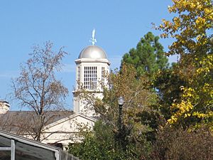
Josephine Street in the fall
|
|

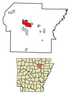
Location of Batesville in Independence County, Arkansas.
|
|
| Country | United States |
| State | Arkansas |
| County | Independence |
| Founded | 1821 |
| Incorporated | 1822 |
| Area | |
| • Total | 11.71 sq mi (30.33 km2) |
| • Land | 11.60 sq mi (30.03 km2) |
| • Water | 0.11 sq mi (0.30 km2) |
| Elevation | 377 ft (115 m) |
| Population
(2020)
|
|
| • Total | 11,191 |
| • Density | 965.16/sq mi (372.64/km2) |
| Time zone | UTC-6 (CST) |
| • Summer (DST) | UTC-5 (CDT) |
| ZIP codes |
72501, 72503
|
| Area code(s) | 870 |
| FIPS code | 05-04030 |
| GNIS feature ID | 2403819 |
| Website | Official Website for the City of Batesville, Arkansas: http://www.cityofbatesville.com/ |
Batesville is a city in Arkansas, United States. It is the main city and county seat of Independence County. Batesville is about 80 miles (128 km) northeast of Little Rock, which is the capital of Arkansas.
In 2020, about 11,191 people lived in Batesville. The city is an important center for making and distributing goods in the Ozark Mountains area and Northeast Arkansas.
Contents
History of Batesville
Batesville is one of the oldest cities in Arkansas. It was named after James Woodson Bates, who was the first person to represent Arkansas in the U.S. Congress. He also lived in the town. In the past, Batesville was also known by the names Napoleon and Poke Bayou.
Early Days as a River Port
In its early days, Batesville was a very important port on the White River. It was a key entry point for people traveling into northern Arkansas. The city played a big part in settling the Ozark Mountains region. It also served as the main land office for northern Arkansas, where people could buy land.
The first known settlement in the Batesville area was around 1810. It was located near the mouth of Polk Bayou. By 1819, the town had a ferry to cross the White River and about a dozen houses. Batesville officially became a town in early 1821. On March 3, 1822, the town's map was officially recorded. Batesville became the county seat in 1821.
In January 1822, Judge Richard Searcy opened the town's first state court. The first post office in Batesville was set up in 1822. In 1830, it became home to a county court. On September 25, 1836, soon after Arkansas became a state, Governor Conway started the Batesville Academy. This was the first academy (a type of school) in the state.
In the past, the area around Batesville had many quarries. These were places where people dug up valuable rocks and minerals. These included manganese ore, phosphate rock, sandstone, limestone, and marble.
Batesville in Modern Times
From 1940 to 1941, Batesville had its own minor league baseball team called the Batesville Pilots. They were part of the Northeast Arkansas League. The team stopped playing in 1941.
Batesville is home to Batesville High School. It also has Lyon College, which is a private college linked to the Presbyterian Church (U.S.A.). Lyon College is famous for its yearly Arkansas Scottish Festival in the fall. The city is also home to the University of Arkansas Community College at Batesville (UACCB). Famous NASCAR driver Mark Martin is from Batesville.
The city has three historic districts listed on the National Register of Historic Places. Many other buildings are also listed there. In 1992, Batesville was named one of The 100 Best Small Towns in America. It was ranked #75.
Geography and Climate
Batesville is located at 35°46′25″N 91°38′29″W / 35.77361°N 91.64139°W. The city is situated right on the White River.
The United States Census Bureau says that Batesville covers about 11.11 square miles (28.77 square kilometers). Most of this area is land, with a small part being water.
Weather in Batesville
| Climate data for Batesville, Arkansas (1991–2020 normals, extremes 1948–present) | |||||||||||||
|---|---|---|---|---|---|---|---|---|---|---|---|---|---|
| Month | Jan | Feb | Mar | Apr | May | Jun | Jul | Aug | Sep | Oct | Nov | Dec | Year |
| Record high °F (°C) | 79 (26) |
85 (29) |
89 (32) |
94 (34) |
98 (37) |
110 (43) |
112 (44) |
111 (44) |
106 (41) |
98 (37) |
86 (30) |
81 (27) |
112 (44) |
| Mean maximum °F (°C) | 68.3 (20.2) |
72.6 (22.6) |
79.3 (26.3) |
84.3 (29.1) |
89.1 (31.7) |
95.3 (35.2) |
98.8 (37.1) |
99.0 (37.2) |
95.0 (35.0) |
86.8 (30.4) |
77.1 (25.1) |
69.7 (20.9) |
101.2 (38.4) |
| Mean daily maximum °F (°C) | 47.9 (8.8) |
52.0 (11.1) |
60.8 (16.0) |
71.0 (21.7) |
78.8 (26.0) |
87.2 (30.7) |
90.7 (32.6) |
90.3 (32.4) |
83.7 (28.7) |
72.8 (22.7) |
60.3 (15.7) |
50.6 (10.3) |
70.5 (21.4) |
| Daily mean °F (°C) | 38.0 (3.3) |
41.3 (5.2) |
49.5 (9.7) |
59.4 (15.2) |
68.2 (20.1) |
76.5 (24.7) |
80.2 (26.8) |
79.0 (26.1) |
71.9 (22.2) |
60.7 (15.9) |
49.3 (9.6) |
40.7 (4.8) |
59.6 (15.3) |
| Mean daily minimum °F (°C) | 28.2 (−2.1) |
30.7 (−0.7) |
38.1 (3.4) |
47.7 (8.7) |
57.6 (14.2) |
65.7 (18.7) |
69.6 (20.9) |
67.7 (19.8) |
60.1 (15.6) |
48.6 (9.2) |
38.3 (3.5) |
30.8 (−0.7) |
48.6 (9.2) |
| Mean minimum °F (°C) | 12.0 (−11.1) |
16.0 (−8.9) |
22.6 (−5.2) |
33.1 (0.6) |
43.6 (6.4) |
55.1 (12.8) |
61.0 (16.1) |
58.6 (14.8) |
47.1 (8.4) |
33.5 (0.8) |
23.6 (−4.7) |
16.2 (−8.8) |
9.7 (−12.4) |
| Record low °F (°C) | −11 (−24) |
−15 (−26) |
9 (−13) |
23 (−5) |
30 (−1) |
41 (5) |
48 (9) |
45 (7) |
31 (−1) |
20 (−7) |
9 (−13) |
−6 (−21) |
−15 (−26) |
| Average precipitation inches (mm) | 3.56 (90) |
3.73 (95) |
4.74 (120) |
5.58 (142) |
4.97 (126) |
3.73 (95) |
4.09 (104) |
3.48 (88) |
3.60 (91) |
3.73 (95) |
4.87 (124) |
4.76 (121) |
50.84 (1,291) |
| Average snowfall inches (cm) | 0.6 (1.5) |
0.8 (2.0) |
0.4 (1.0) |
0.0 (0.0) |
0.0 (0.0) |
0.0 (0.0) |
0.0 (0.0) |
0.0 (0.0) |
0.0 (0.0) |
0.0 (0.0) |
0.1 (0.25) |
0.3 (0.76) |
2.2 (5.6) |
| Average precipitation days (≥ 0.01 in) | 8.6 | 8.3 | 10.8 | 9.4 | 10.5 | 8.1 | 8.4 | 7.5 | 7.1 | 8.3 | 8.6 | 8.7 | 104.3 |
| Average snowy days (≥ 0.1 in) | 0.5 | 0.5 | 0.2 | 0.0 | 0.0 | 0.0 | 0.0 | 0.0 | 0.0 | 0.0 | 0.1 | 0.2 | 1.5 |
| Source: NOAA | |||||||||||||
Batesville has a humid subtropical climate. This means it has hot, humid summers and winters that are usually mild to cool.
People of Batesville
| Historical population | |||
|---|---|---|---|
| Census | Pop. | %± | |
| 1850 | 848 | — | |
| 1860 | 920 | 8.5% | |
| 1870 | 881 | −4.2% | |
| 1880 | 1,264 | 43.5% | |
| 1890 | 2,150 | 70.1% | |
| 1900 | 2,327 | 8.2% | |
| 1910 | 3,399 | 46.1% | |
| 1920 | 4,299 | 26.5% | |
| 1930 | 4,484 | 4.3% | |
| 1940 | 5,267 | 17.5% | |
| 1950 | 6,414 | 21.8% | |
| 1960 | 6,207 | −3.2% | |
| 1970 | 7,209 | 16.1% | |
| 1980 | 8,447 | 17.2% | |
| 1990 | 9,187 | 8.8% | |
| 2000 | 9,445 | 2.8% | |
| 2010 | 10,248 | 8.5% | |
| 2020 | 11,191 | 9.2% | |
| U.S. Decennial Census | |||
Population in 2020
In 2020, the census counted 11,191 people living in Batesville. There were 3,985 households and 2,448 families in the city.
| Race | Number | Percentage |
|---|---|---|
| White (non-Hispanic) | 7,807 | 69.76% |
| Black or African American (non-Hispanic) | 479 | 4.28% |
| Native American | 39 | 0.35% |
| Asian | 222 | 1.98% |
| Pacific Islander | 12 | 0.11% |
| Other/Mixed | 529 | 4.73% |
| Hispanic or Latino | 2,103 | 18.79% |
Population in 2010
The census in 2010 showed that 10,243 people lived in Batesville. There were 3,777 households. About 28.5% of these households had children under 18 living there. The average household had 2.28 people.
The people living in Batesville were:
- 83.2% White
- 4.3% Black or African American
- 0.6% Native American
- 1.5% Asian
- 0.3% Pacific Islander
- 1.40% from other races
- 2.00% from two or more races.
About 4.6% of the people were Hispanics or Latinos.
The median age in Batesville was 38 years old. This means half the people were older than 38 and half were younger.
Education in Batesville
The public schools in Batesville are part of the Batesville School District, Arkansas. The district has:
- One early learning center
- One junior high school
- One high school (which is Batesville High School)
- Three elementary schools
Transportation
Batesville is connected by several important highways:
 U.S. Highway 167
 Arkansas Highway 25
 Arkansas Highway 69
 Arkansas Highway 69 Business
 Arkansas Highway 106
 Arkansas Highway 233
 Arkansas Highway 394
Famous People from Batesville
- Elisha Baxter: He was the 13th governor of Arkansas.
- Jack Critcher: A politician who served at local and state levels.
- Monroe L. Flinn: An Illinois state representative.
- Ryan Mallett: A quarterback for the Arkansas Razorbacks and the NFL's Baltimore Ravens. He was born in Batesville.
- Mark Martin: A member of the NASCAR Hall of Fame. He was born and grew up in Batesville.
- James McLean: A former Democrat member of the Arkansas House of Representatives for Independence County.
- Mike McQueen: A former Major League Baseball player who lived and died in Batesville.
- William R. Miller: The first governor of Arkansas who was born in the state. He was born in Batesville in 1823.
- Rick Monday: A Major League Baseball player and current broadcaster for the Los Angeles Dodgers. He was born in Batesville.
- Leslie Rutledge: The current Arkansas Lieutenant Governor. She was Attorney General from 2015-2023.
- Charlie Strong: A football head coach for the University of South Florida. He also coached for Texas and Louisville.
- James Sturch: A Republican member of the Arkansas House of Representatives for Independence County since 2015.
- Mutha's Day Out: A rock band from the 1990s.
- Sami Jo: A country music singer.
See also
 In Spanish: Batesville (Arkansas) para niños
 | Ernest Everett Just |
 | Mary Jackson |
 | Emmett Chappelle |
 | Marie Maynard Daly |


