Beinn a' Chaorainn (Cairngorms) facts for kids
Quick facts for kids Beinn a' Chaorainn |
|
|---|---|

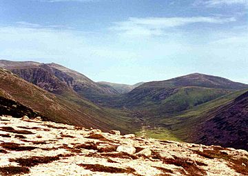
Looking up Glen Derry from the slopes of Derry Cairngorm with Beinn a' Chaorainn (right) and Beinn Mheadhoin (left).
|
|
| Highest point | |
| Elevation | 1,083 m (3,553 ft) |
| Prominence | 245 m (804 ft) |
| Parent peak | Beinn a' Bhuird |
| Listing | Munro, Marilyn |
| Naming | |
| English translation | Mountain of the Rowan Tree |
| Language of name | Gaelic |
| Geography | |
|
Lua error in Module:Location_map at line 420: attempt to index field 'wikibase' (a nil value).
|
|
| Parent range | Grampians |
| OS grid | NJ044013 |
| Topo map | OS Landranger 36, OS Explorers 404, 403 |
| Listed summits of Beinn a' Chaorainn (Cairngorms) | ||||
| Name | Grid ref | Height | Status | |
|---|---|---|---|---|
| Beinn a' Chaorainn Bheag | NJ057017 | 1017 m (3336 ft) | Munro Top | |
Beinn a' Chaorainn is a Scottish mountain found in the middle of the Cairngorms mountain range. It's quite a remote hill, meaning it's far from towns. You can find it about 19 kilometres (12 miles) south-east of Aviemore and 14 kilometres (9 miles) north-west of Braemar. This mountain sits right on the edge of the Moray and Aberdeenshire areas. The name of the hill used to be spelled a bit differently, but it was changed to Beinn a' Chaorainn to make Gaelic spelling more standard.
About Beinn a' Chaorainn
This mountain has a pointed shape, but it's not always easy to spot. It's often hidden by the bigger and more impressive mountains nearby in the Cairngorms. Beinn a' Chaorainn is located at the top of Glen Derry. It faces its taller neighbour, Beinn Mheadhoin, across a mountain pass called the Lairig an Laoigh, which means "The Pass of the Calves."
Beinn a' Chaorainn stands at 1083 metres (3553 feet) tall. This height means it's known as both a Munro and a Marilyn. A Munro is a Scottish mountain over 3,000 feet (914.4 metres) high, and a Marilyn is a hill that stands out from the land around it by at least 150 metres (492 feet). The mountain's name comes from the Gaelic words for "Mountain of the Rowan tree." Even though its name mentions trees, the mountain looks quite bare today. It's good to remember that there's another Munro with the same name, Beinn a' Chaorainn, located near Loch Laggan.
Where Beinn a' Chaorainn Is Located
Beinn a' Chaorainn is on the northern part of a large, flat area called the Moine Bhealaidh, which means "Yellow Moss." This area is mostly flat and stays high, usually above 850 metres (2,789 feet). It's found to the east of the upper part of Glen Derry.
To the south of this flat area is another Munro called Beinn Bhreac. It's about 4.5 kilometres (2.8 miles) south of Beinn a' Chaorainn, across some boggy ground. On its western side, Beinn a' Chaorainn drops steeply down to the Lairig an Laoigh mountain pass. These slopes are mostly covered in grass, but some parts are rocky.
To the east of Beinn a' Chaorainn is a smaller peak called Beinn a' Chaorainn Bheag, which is 1017 metres (3336 feet) tall. It's also listed in Munro's Tables as a "Munro Top," meaning it's a significant peak connected to a Munro. These two peaks are joined by a lower section of land called a col, which is 945 metres (3,100 feet) high. In this col, you can find several small lakes, with the biggest one named Lochan Beinn a' Chaorainn. Further east, about five kilometres (3 miles) from the main summit, is the huge mountain of Beinn a' Bhùird. Beinn a' Chaorainn is connected to Beinn a' Bhùird by the high ground of the Moine Bhealaidh.
The water that flows off Beinn a' Chaorainn goes in two main directions. Some flows south into the Derry Burn, eventually reaching the River Dee and then the sea at Aberdeen. Other water flows north through Glen Avon and the River Spey, finally reaching the Moray Firth.
How to Climb Beinn a' Chaorainn
Climbing Beinn a' Chaorainn, along with its neighbour Beinn Bhreac, is a very long journey. The round trip is more than 28 kilometres (17 miles). Most people start their hike from the Linn of Dee car park, which is about eight kilometres (5 miles) west of Braemar.
The path follows an estate road along Glen Lui for five kilometres (3 miles) until you reach Derry Lodge. Many hikers use bicycles for this first part of the journey. They can leave their bikes safely in the woods near Derry Lodge and pick them up on their way back. From Derry Lodge, the route goes north up Glen Derry for two kilometres (1.2 miles). Then, you climb the western slopes of Beinn Bhreac. After that, you continue north for almost five kilometres (3 miles) across the Moine Bhealaidh to reach the top of Beinn a' Chaorainn.
It's also possible to approach the mountain from the Aviemore side of the Cairngorms, starting at the Cairn Gorm ski centre. However, this way involves crossing or going around other big mountains like Cairn Gorm, Loch Avon, and Beinn Mheadhoin. This makes it a very long and challenging hike.
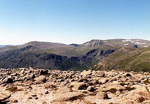
From the top of Beinn a' Chaorainn, you get an amazing view of all the giant mountains in the Cairngorms. However, if there's snow and clouds, be careful of the cornices (overhanging ledges of snow) on the flat plateau, as they can be dangerous.
 | George Robert Carruthers |
 | Patricia Bath |
 | Jan Ernst Matzeliger |
 | Alexander Miles |


