Big Stone County, Minnesota facts for kids
Quick facts for kids
Big Stone County
|
|
|---|---|

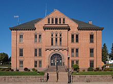
Big Stone County Courthouse in Ortonville, Minnesota.
|
|

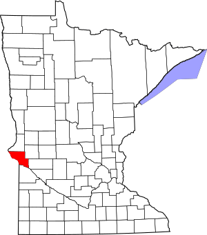
Location within the U.S. state of Minnesota
|
|
 Minnesota's location within the U.S. |
|
| Country | |
| State | |
| Founded | February 20, 1862 (created) 1874 (organized) |
| Named for | Big Stone Lake |
| Seat | Ortonville |
| Largest city | Ortonville |
| Area | |
| • Total | 528 sq mi (1,370 km2) |
| • Land | 499 sq mi (1,290 km2) |
| • Water | 29 sq mi (80 km2) 5.5%% |
| Population
(2020)
|
|
| • Total | 5,166 |
| • Estimate
(2023)
|
5,105 |
| • Density | 10.1/sq mi (3.9/km2) |
| Time zone | UTC−6 (Central) |
| • Summer (DST) | UTC−5 (CDT) |
| Congressional district | 7th |
Big Stone County is a place in the state of Minnesota, USA. It's like a big district or area. As of the year 2020, about 5,166 people lived there. The main town and center of the county is Ortonville.
Contents
History
Big Stone County was officially created in 1862. It started to be organized and run as a county in 1874. The county got its name from a large body of water called Big Stone Lake.
Geography
Big Stone County is located on the western side of Minnesota. Its southwestern border touches the state of South Dakota. The Little Minnesota River flows along this southwestern edge.
Since 1937, a special dam called the Big Stone Lake Dam has held back the river's water. This created Big Stone Lake. Water flowing out of this lake then becomes the Minnesota River. Fish Creek also flows through the northwestern part of the county. It empties into Big Stone Lake.
The land in Big Stone County has gentle, rolling hills. Some areas have trees, while others are used for farming. The land generally slopes towards the south and east. The highest point in the county is about 1,201 feet (366 meters) above sea level. The county covers a total area of 528 square miles (1,368 square kilometers). Most of this area, 499 square miles (1,292 square kilometers), is land. The remaining 29 square miles (75 square kilometers) is water.
Lakes
Big Stone County is home to many lakes. Here are some of them:
- Artichoke Lake
- Barry Lake
- Bentsen Lake
- Big Stone Lake
- Clear Lake
- Cup Lake
- Deep Lake
- East Toqua Lake
- Eli Lake
- Fogarty Lake
- Horseshoe Lake
- Lannon Lake
- Lindgren Lake
- Lake Leo
- Lone Tree Lake
- Long Lake
- Long Tom Lake
- Lysing Lake
- Marsh Lake
- Moonshine Lake
- Moulton Lake
- Mundweiler Lake
- Munnwyler Lake
- Olson Lake
- Otrey Lake
- Peterson Lake
- South Rothwell Lake
- Smithwicks Lake
- Swenson Lake
- Twin Lakes
- West Toqua Lake
- Walter Lake
Major Roads
These are the main highways that go through Big Stone County:
 U.S. Highway 12
 U.S. Highway 75
 Minnesota State Highway 7
 Minnesota State Highway 28
Neighboring Counties
Big Stone County shares its borders with these other counties:
- Traverse County (north)
- Stevens County (northeast)
- Swift County (southeast)
- Lac qui Parle County (south)
- Grant County, South Dakota (southwest)
- Roberts County, South Dakota (northwest)
Protected Natural Areas
Big Stone County has several special areas set aside to protect nature:
- Big Stone Lake State Park
- Big Stone National Wildlife Refuge (part)
- Big Stone Wildlife Management Preserve (part)
- Bonanza Prairie Scientific and Natural Area
- Clinton Prairie Scientific and Natural Area
- Dismal Swamp State Wildlife Management Area
- Freed State Wildlife Management Area
- Lac qui Parle State Wildlife Management Area
- Otrey State Wildlife Management Area
- Reisdorph State Wildlife Management Area
- Victor State Wildlife Management Area
Climate and Weather
| Weather chart for Ortonville, Minnesota | |||||||||||||||||||||||||||||||||||||||||||||||
|---|---|---|---|---|---|---|---|---|---|---|---|---|---|---|---|---|---|---|---|---|---|---|---|---|---|---|---|---|---|---|---|---|---|---|---|---|---|---|---|---|---|---|---|---|---|---|---|
| J | F | M | A | M | J | J | A | S | O | N | D | ||||||||||||||||||||||||||||||||||||
|
0.6
23
1
|
0.6
27
7
|
1.4
39
19
|
2.6
56
32
|
2.5
69
45
|
3.6
78
56
|
3.9
84
60
|
2.7
82
58
|
2.6
73
47
|
2.2
59
34
|
1
41
21
|
0.4
25
7
|
||||||||||||||||||||||||||||||||||||
| temperatures in °F precipitation totals in inches source: The Weather Channel |
|||||||||||||||||||||||||||||||||||||||||||||||
|
Metric conversion
|
|||||||||||||||||||||||||||||||||||||||||||||||
In Ortonville, the main town, the average temperature in January is about 1°F (-17°C). In July, it's around 84°F (29°C). The coldest temperature ever recorded was -44°F (-42°C) in February 1994. The hottest was 108°F (42°C) in July 1966.
The amount of rain and snow changes throughout the year. December usually has the least, about 0.43 inches (1.1 cm). July typically has the most, about 3.85 inches (9.8 cm).
Population Information
| Historical population | |||
|---|---|---|---|
| Census | Pop. | %± | |
| 1870 | 24 | — | |
| 1880 | 3,688 | 15,266.7% | |
| 1890 | 5,722 | 55.2% | |
| 1900 | 8,731 | 52.6% | |
| 1910 | 9,367 | 7.3% | |
| 1920 | 9,766 | 4.3% | |
| 1930 | 9,838 | 0.7% | |
| 1940 | 10,447 | 6.2% | |
| 1950 | 9,607 | −8.0% | |
| 1960 | 8,954 | −6.8% | |
| 1970 | 7,941 | −11.3% | |
| 1980 | 7,716 | −2.8% | |
| 1990 | 6,285 | −18.5% | |
| 2000 | 5,820 | −7.4% | |
| 2010 | 5,269 | −9.5% | |
| 2020 | 5,166 | −2.0% | |
| 2023 (est.) | 5,105 | −3.1% | |
| U.S. Decennial Census 1790-1960 1900-1990 1990-2000 2010-2020 |
|||
The population of Big Stone County has changed over the years. In 1870, only 24 people lived there. The population grew a lot by 1940, reaching over 10,000 people. Since then, the number of people living in the county has slowly decreased. In 2020, there were 5,166 residents.
2020 Population Breakdown
Here's a look at the different groups of people living in Big Stone County in 2020:
| Race | Num. | Perc. |
|---|---|---|
| White (not Hispanic) | 4,809 | 93.1% |
| Black or African American (not Hispanic) | 19 | 0.37% |
| Native American (not Hispanic) | 34 | 0.66% |
| Asian (not Hispanic) | 12 | 0.23% |
| Pacific Islander (not Hispanic) | 4 | 0.07% |
| Other/Mixed (not Hispanic) | 148 | 2.7% |
| Hispanic or Latino | 140 | 2.7% |
Towns and Areas
Big Stone County has several towns and smaller communities.
Cities
These are the main cities in the county:
Smaller Communities
These are smaller, unincorporated communities in the county:
Townships
The county is also divided into these townships:
- Akron Township
- Almond Township
- Artichoke Township
- Big Stone Township
- Browns Valley Township
- Foster Township
- Graceville Township
- Malta Township
- Moonshine Township
- Odessa Township
- Ortonville Township
- Otrey Township
- Prior Township
- Toqua Township
Education
Children in Big Stone County attend schools in these districts:
- Chokio-Alberta Public School District
- Clinton-Graceville-Beardsley School District
- Lac Qui Parle Valley School District
- Ortonville Public Schools
See also
 In Spanish: Condado de Big Stone para niños

