Blooming Grove, New York facts for kids
Quick facts for kids
Blooming Grove, New York
|
|
|---|---|

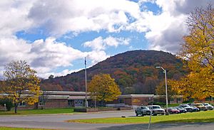
Round Hill from New York State Route 208 in 2006
|
|

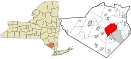
Location in Orange County and the state of New York.
|
|
| Country | United States |
| State | New York |
| County | Orange |
| Government | |
| • Type | Town Council |
| Area | |
| • Total | 35.35 sq mi (91.56 km2) |
| • Land | 34.74 sq mi (89.97 km2) |
| • Water | 0.62 sq mi (1.60 km2) |
| Elevation | 374 ft (114 m) |
| Population
(2020)
|
|
| • Total | 18,811 |
| Time zone | UTC-5 (Eastern (EST)) |
| • Summer (DST) | UTC-4 (EDT) |
| ZIP code |
10914 (Also serviced by the Monroe post office ZIP 10950)
|
| Area code(s) | 845 |
| FIPS code | 36-07003 |
| GNIS feature ID | 0978739 |
Blooming Grove is a town in Orange County, New York, United States. It's located in the central part of the county, southwest of Newburgh. In 2020, about 18,811 people lived here.
Contents
History of Blooming Grove
Early Settlers and Town Formation
The first known settler in Blooming Grove was likely Vincent Mathews. He bought a large piece of land called the Rip Van Dam patent in 1721. He built a grist mill, which is a mill for grinding grain, and named his settlement "Mathewsfield." Vincent Mathews had two sons, David and Fletcher, who were known as Loyalists. This meant they supported the British during the American Revolutionary War. David Mathews even served as the Mayor of New York during the war.
The town of Blooming Grove was officially formed in 1799. It was created from a larger area that was once part of the town of Cornwall. Over the years, parts of Blooming Grove were used to create other towns. In 1830, the town of Hamptonburgh was formed. Later, in 1845, a part of Blooming Grove became the town of Chester. More recently, in 2006, the village of South Blooming Grove became its own incorporated village.
Notable People and Places
Andrew Jackson Davis, who was known as the "Poughkeepsie Seer," was born in Blooming Grove in 1826. He was a spiritualist and writer.
Blooming Grove is also home to a very special place: the Brotherhood Winery in Washingtonville. This winery started in 1839 and is the oldest winery in the United States that has been open continuously ever since!
Geography of Blooming Grove
Blooming Grove covers a total area of about 35.3 square miles (91.5 square kilometers). Most of this area is land, with a small part being water.
Important roads like New York State Route 17 and U.S. Route 6 pass through the southern part of Blooming Grove, making it easy to travel to and from the town.
Population and People
| Historical population | |||
|---|---|---|---|
| Census | Pop. | %± | |
| 1800 | 1,611 | — | |
| 1810 | 1,759 | 9.2% | |
| 1820 | 2,219 | 26.2% | |
| 1830 | 2,099 | −5.4% | |
| 1840 | 2,396 | 14.1% | |
| 1850 | 2,184 | −8.8% | |
| 1860 | 2,248 | 2.9% | |
| 1870 | 2,502 | 11.3% | |
| 1880 | 2,444 | −2.3% | |
| 1890 | 2,236 | −8.5% | |
| 1900 | 2,188 | −2.1% | |
| 1910 | 2,110 | −3.6% | |
| 1920 | 1,881 | −10.9% | |
| 1930 | 1,922 | 2.2% | |
| 1940 | 2,312 | 20.3% | |
| 1950 | 2,410 | 4.2% | |
| 1960 | 3,777 | 56.7% | |
| 1970 | 8,813 | 133.3% | |
| 1980 | 12,339 | 40.0% | |
| 1990 | 16,673 | 35.1% | |
| 2000 | 17,351 | 4.1% | |
| 2010 | 18,028 | 3.9% | |
| 2020 | 18,811 | 4.3% | |
| U.S. Decennial Census | |||
In 2010, there were about 18,028 people living in Blooming Grove. The town had 6,284 households, which are groups of people living together. Many of these households (39.5%) included children under 18 years old. About 62% of households were married couples.
The population of Blooming Grove includes people of all ages. About 25.3% of the people were under 18 years old, and 11.6% were 65 years or older. The average age in the town was about 40.8 years.
Most people in Blooming Grove speak English. About 12.1% of people aged five and older could speak Spanish. Many people in Blooming Grove have Irish, Italian, or German backgrounds.
Communities and Locations in Blooming Grove
Blooming Grove is made up of several smaller communities and interesting places:
- Beaver Dam Lake – A small community that is partly in Blooming Grove and partly in other towns like New Windsor and Cornwall.
- Beaverdam Lake – A lake surrounded by the Beaver Dam Lake community.
- Blooming Grove – This is the main community (hamlet) of Blooming Grove. It's located on state route 94.
- Bull Mine – A community in the southern part of the town, found on state route 208.
- Craigville – Another community south of the main Blooming Grove hamlet, also on state route 94.
- Mountain Lodge Park – This used to be a summer community. It's located on Schunemunk Mountain.
- Oxford – A community in the southern part of town, near state route 17.
- Salisbury Mills – A community on the eastern edge of the town, also on NY-94. It's partly in the town of Cornwall.
- Schunnemunk Mountain – This is the tallest mountain in Orange County. It's located right on the eastern border of the town.
- The village of South Blooming Grove.
- Tomahawk Lake – A lake located near the western border of the town.
- Washingtonville – This village is where state highways 94 and 208 meet.
See also
 In Spanish: Blooming Grove (Nueva York) para niños
 | Shirley Ann Jackson |
 | Garett Morgan |
 | J. Ernest Wilkins Jr. |
 | Elijah McCoy |


