Boone County, Indiana facts for kids
Quick facts for kids
Boone County
|
|
|---|---|

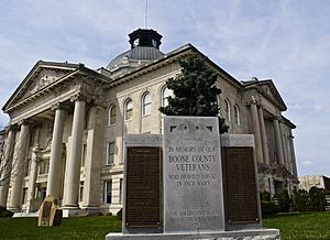
Boone County Courthouse in Lebanon
|
|

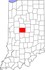
Location within the U.S. state of Indiana
|
|
 Indiana's location within the U.S. |
|
| Country | |
| State | |
| Founded | April 1, 1830 (created) 1831 (organized) |
| Named for | Daniel Boone |
| Seat | Lebanon |
| Largest city | Zionsville |
| Area | |
| • Total | 423.25 sq mi (1,096.2 km2) |
| • Land | 422.91 sq mi (1,095.3 km2) |
| • Water | 0.34 sq mi (0.9 km2) 0.08%% |
| Population
(2020)
|
|
| • Total | 70,812 |
| • Density | 167.3054/sq mi (64.5970/km2) |
| Congressional districts | 4th, 5th |
| Indiana county number 6 | |
Boone County is a place in the state of Indiana, USA. It's like a big district or area. In 2020, about 70,812 people lived there. The main town, or county seat, is Lebanon.
Contents
History of Boone County
How Indiana Became a State
Long ago, in 1787, the new country of the United States created a huge area called the Northwest Territory. This territory included the land where Indiana is today.
In 1800, a part of this territory became Ohio. The rest was named the Indiana Territory. Thomas Jefferson, who was president, chose William Henry Harrison to be its first leader. The capital city was Vincennes.
Later, other parts of the Indiana Territory became the Michigan Territory and the Illinois Territory. This made Indiana the size it is now. Finally, in December 1816, Indiana officially became a state in the USA.
Boone County's Beginning
Before Boone County was formed, the land belonged to Native American tribes. The U.S. government gained control of this land through treaties, like the 1809 Treaty of Fort Wayne and the 1818 Treaty of St. Mary's. This included the area that would become Boone County.
Boone County was officially created by the state of Indiana on April 1, 1830. It was named after a famous explorer and frontiersman, Daniel Boone.
The first county seat was Jamestown. But soon after, officials decided to find a more central location. They chose the future city of Lebanon to be the permanent county seat.
Geography of Boone County
Where is Boone County?
Boone County is located close to the center of Indiana. It is about 24 miles (39 km) wide from east to west and 17.5 miles (28.2 km) long from north to south.
The county covers about 418.5 square miles (1,085 square kilometers). A large part of this land, about two-thirds, is used for farming. Its location, good soil, and water sources have always been helpful for the area.
The highest point in Boone County is a small hill near Lebanon. It is about 984 feet (300 meters) above sea level.
Rivers and Creeks
Different parts of Boone County are drained by various creeks. Sugar Creek flows through the northern part. Big Raccoon Creek drains the southwest. Eagle Creek and its smaller streams flow through the southeast. These creeks help carry water out of the county.
Neighboring Counties
Boone County shares its borders with these other counties:
- Clinton County to the north
- Hamilton County to the east
- Marion County to the southeast
- Hendricks County to the south
- Montgomery County to the west
Cities and Towns in Boone County
The main city and county seat is:
Other towns in Boone County include:
There are also many smaller communities that are not officially cities or towns, such as Dover, Elizaville, and Rosston.
Local Divisions: Townships
Boone County is divided into smaller areas called townships. These help organize local services. Some of these townships are:
|
|
|
Transportation in Boone County
Boone County has several important roads and a regional airport.
Major Highways
Many major highways pass through Boone County, connecting it to other parts of Indiana and beyond:
 Interstate 65
 Interstate 74
 Interstate 465
 Interstate 865
 U.S. Route 52
 U.S. Route 136
 U.S. Route 421
 Indiana State Road 32
 Indiana State Road 38
 Indiana State Road 39
 Indiana State Road 47
 Indiana State Road 75
 Indiana State Road 234
 Indiana State Road 267
Airport and Railroads
The Indianapolis Executive Airport (KTYQ) is located in Boone County. It serves private and business flights. The CSX Transportation railroad also runs through the county.
Education in Boone County
Public schools in Boone County are managed by different school districts. These include the Lebanon Community School Corporation, Western Boone County Community School District, and Zionsville Community Schools.
Climate and Weather in Boone County
| Weather chart for Lebanon, Indiana | |||||||||||||||||||||||||||||||||||||||||||||||
|---|---|---|---|---|---|---|---|---|---|---|---|---|---|---|---|---|---|---|---|---|---|---|---|---|---|---|---|---|---|---|---|---|---|---|---|---|---|---|---|---|---|---|---|---|---|---|---|
| J | F | M | A | M | J | J | A | S | O | N | D | ||||||||||||||||||||||||||||||||||||
|
2.4
34
18
|
2.4
41
22
|
3.4
52
31
|
3.8
65
40
|
4.5
75
50
|
4.2
84
60
|
4.5
86
63
|
3.6
85
61
|
3
79
53
|
2.9
67
43
|
3.7
52
34
|
3.1
39
23
|
||||||||||||||||||||||||||||||||||||
| temperatures in °F precipitation totals in inches source: The Weather Channel |
|||||||||||||||||||||||||||||||||||||||||||||||
|
Metric conversion
|
|||||||||||||||||||||||||||||||||||||||||||||||
The weather in Boone County changes throughout the year. In Lebanon, the average temperature in January is about 18°F (-8°C). In July, it's warmer, around 86°F (30°C).
The coldest temperature ever recorded was -27°F (-33°C) in January 1994. The hottest was 112°F (44°C) in July 1936. The amount of rain also changes, with July usually being the wettest month.
Population of Boone County
How Many People Live Here?
The number of people living in Boone County has grown a lot over the years.
| Historical population | |||
|---|---|---|---|
| Census | Pop. | %± | |
| 1830 | 621 | — | |
| 1840 | 8,121 | 1,207.7% | |
| 1850 | 11,631 | 43.2% | |
| 1860 | 16,753 | 44.0% | |
| 1870 | 22,593 | 34.9% | |
| 1880 | 25,922 | 14.7% | |
| 1890 | 26,572 | 2.5% | |
| 1900 | 26,321 | −0.9% | |
| 1910 | 24,673 | −6.3% | |
| 1920 | 23,575 | −4.5% | |
| 1930 | 22,290 | −5.5% | |
| 1940 | 22,081 | −0.9% | |
| 1950 | 23,993 | 8.7% | |
| 1960 | 27,543 | 14.8% | |
| 1970 | 30,870 | 12.1% | |
| 1980 | 36,446 | 18.1% | |
| 1990 | 38,147 | 4.7% | |
| 2000 | 46,107 | 20.9% | |
| 2010 | 56,640 | 22.8% | |
| 2020 | 70,812 | 25.0% | |
| 2023 (est.) | 76,120 | 34.4% | |
| US Decennial Census 1790-1960 1900-1990 1990-2000 2010 |
|||
In 2010, there were 56,640 people living in Boone County. By 2020, the population had grown to 70,812 people.
Who Lives in Boone County?
According to the 2020 census, most people in Boone County are White. There are also people from many other backgrounds. This includes Black or African American, Asian, Native American, and people of two or more races. Some residents are also of Hispanic or Latino origin.
| Race | Number | Percentage |
|---|---|---|
| White (not Hispanic) | 61,135 | 86.3% |
| Black or African American (not Hispanic) | 1,426 | 2% |
| Native American (not Hispanic) | 128 | 0.2% |
| Asian (not Hispanic) | 2,389 | 3.37% |
| Pacific Islander (not Hispanic) | 19 | 0.03% |
| Other/Mixed (not Hispanic) | 2,940 | 4.15% |
| Hispanic or Latino | 2,775 | 4% |
See also
 In Spanish: Condado de Boone (Indiana) para niños
 | Mary Eliza Mahoney |
 | Susie King Taylor |
 | Ida Gray |
 | Eliza Ann Grier |

