Bread Loaf Mountain facts for kids
Quick facts for kids Bread Loaf Mountain |
|
|---|---|

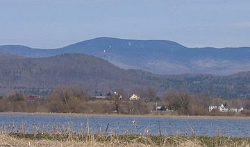
A distant view of Bread Loaf from Otter Creek, April 2007
|
|
| Highest point | |
| Elevation | 3,822 ft (1,165 m) |
| Prominence | 1,430 ft (440 m) |
| Listing | |
| Geography | |
| Location | Addison County, Vermont |
| Parent range | Green Mountains |
| Topo map | USGS Bread Loaf and Lincoln |
| Climbing | |
| Easiest route | Maintained hiking trail |
Bread Loaf Mountain is a tall mountain in Addison County, Vermont. It's located inside the Breadloaf Wilderness, which is part of the Green Mountain National Forest. This mountain is a key part of the central Green Mountains range. Nearby, to the northeast, you'll find Mount Wilson, another peak in Vermont's Presidential Range.
Contents
About Bread Loaf Mountain
Where is Bread Loaf Mountain?
Bread Loaf Mountain stands proudly in Addison County, Vermont. It's a significant part of the Green Mountains, a long mountain range that runs through Vermont. Just a bit to the northeast, you can see Mount Wilson.
Water's Journey from the Mountain
Water from Bread Loaf Mountain flows in many directions. It eventually reaches different rivers and even the ocean! It's like the mountain helps feed many waterways.
East Side Waters
On the southeast side of Bread Loaf Mountain, water starts its journey into the White River. This river then joins the Connecticut River. The Connecticut River flows all the way to Long Island Sound in Connecticut.
The east side of the mountain sends water into the beginnings of the New Haven River. This river then flows into Otter Creek. From there, the water goes into Lake Champlain, then into Canada's Richelieu River. Finally, it reaches the Saint Lawrence River and eventually the Gulf of Saint Lawrence.
West Side Waters
The northern part of the mountain's west side drains into Blue Bank Brook. This brook also joins the New Haven River.
The southern part of the west side sends water into Sparks Brook. It also feeds the Middle Branch of the Middlebury River. These waters then flow into the Middlebury River near Ripton and finally into Otter Creek.
Exploring Bread Loaf: The Long Trail
The Long Trail is a very long hiking path in Vermont. It stretches for about 272-mile (438 km) across the entire state. This trail crosses the southeastern part of Bread Loaf Mountain.
To reach the very top of Bread Loaf Mountain, hikers take a shorter path. This path branches off from the Long Trail and leads northwest to a great viewpoint. You can get to this part of the Long Trail in a few ways. One way is using the Skyline Pond Trail, which starts from USFS 59 (Steam Mill Road). Another option is the Clark Brook Trail, off USFS 55. You can also use the Emily Proctor Trail, which starts from USFS 201.
 | William M. Jackson |
 | Juan E. Gilbert |
 | Neil deGrasse Tyson |

