Bridgeton, Missouri facts for kids
Quick facts for kids
Bridgeton, Missouri
|
|
|---|---|

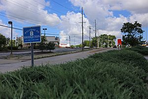
Welcome sign, Bridgeton, July 2016
|
|

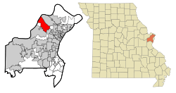
Location of Bridgeton, Missouri
|
|
| Country | United States |
| State | Missouri |
| County | St. Louis |
| Area | |
| • Total | 15.24 sq mi (90.00 km2) |
| • Land | 14.55 sq mi (37.69 km2) |
| • Water | 0.69 sq mi (1.77 km2) |
| Elevation | 541 ft (165 m) |
| Population
(2020)
|
|
| • Total | 11,445 |
| • Density | 786.44/sq mi (303.65/km2) |
| Time zone | UTC-6 (Central (CST)) |
| • Summer (DST) | UTC-5 (CDT) |
| ZIP code |
63044
|
| Area code(s) | 314/557 |
| FIPS code | 29-08398 |
| GNIS feature ID | 2393417 |
Bridgeton is a city in St. Louis County, Missouri, United States. It is a suburb of Greater St. Louis. Bridgeton is known for being a major transport hub in the area. This is because it sits where two big highways, I-270 and I-70, meet.
Part of the St. Louis Lambert International Airport is also located within Bridgeton. In 2020, about 11,445 people lived in Bridgeton.
Contents
Where is Bridgeton Located?
Bridgeton is found between the Lambert-St. Louis International Airport and St. Charles. The Missouri River forms the city's northwestern edge.
This area has always been important for travel. Long ago, Native American trails, like those used by the Osage Nation, passed through here. These trails later became some of the first roads, such as Natural Bridge and the historic St. Charles Rock Road. These roads were used by Spanish, French, and early American settlers.
Today, the meeting point of I-70 and I-270, along with air and rail access, makes Bridgeton a great spot for businesses that need good transportation. The American Discovery Trail, a path for recreation, also goes through the area.
The city covers about 15.24 square miles (39.5 square kilometers). Most of this area is land, with a smaller part being water.
Bridgeton's History
Early Beginnings
The first Europeans to come to this area were French explorers and settlers. One explorer, Étienne de Veniard, Sieur de Bourgmont, traveled through in 1724. He used a trail that became the main route between St. Louis and St. Charles.
Later, the Spanish gained colonial control in 1768. This happened after France lost a war and gave its land west of the Mississippi River to Spain. Spain controlled the area until 1804. Then, the land became part of the United States through the Louisiana Purchase.
Bridgeton was first mapped out in 1794. It was called Marais des Liards, which means "Cottonwood Swamp" in French. It was also known as Village à Robert, named after its founder, Robert Owen. He received land from the Spanish government. As more English-speaking settlers arrived, the village's name changed to Owen's Station.
Because of its location near a ferry crossing the Missouri River, Bridgeton became a popular stop. It was a place to rest on the journey from St. Louis to St. Charles. Meriwether Lewis, from the Lewis and Clark Expedition, passed through here. The city officially became a state charter in 1843. For many years, it was a stop for people heading west on the Oregon and Santa Fe trails.
In 1851, a Catholic religious group called the Jesuits started St. Mary's Church in Bridgeton. It began as a mission to serve local Catholics and quickly became a full parish. However, the church closed in 2001. This was due to the expansion of Lambert-St. Louis International Airport, which caused many people to move away.
Modern Growth
By 1950, Bridgeton had a small population of 276 people. But in the 1950s, the city grew a lot by adding nearby areas. It expanded to about 16 square miles (41 square kilometers). During this time, the Northwest Chamber of Commerce was also started. This group helps businesses in the Bridgeton area.
The 1960s saw a big boom in new homes. Nearly 8,000 single-family homes were built. Many apartment buildings were also constructed. This growth continued through the 1970s and 1980s.
In 1968, the city bought the Payne-Gentry House. This is the oldest home in Bridgeton. It was later added to the National Register of Historic Places. It also has the oldest doctor's office still standing in Missouri.
While not many new homes were built in the 1990s, the city saw a lot of new businesses. Being close to the river, highways, trains, and the airport helped Bridgeton continue to grow. However, being near the Lambert-Saint Louis International Airport also brought challenges. Starting in 1995, the airport planned a new runway. This plan led to about 2,000 homes in Bridgeton being removed. This greatly affected the city's population.
Population Information
| Historical population | |||
|---|---|---|---|
| Census | Pop. | %± | |
| 1880 | 197 | — | |
| 1890 | 237 | 20.3% | |
| 1900 | 178 | −24.9% | |
| 1910 | 129 | −27.5% | |
| 1920 | 121 | −6.2% | |
| 1930 | 152 | 25.6% | |
| 1940 | 169 | 11.2% | |
| 1950 | 202 | 19.5% | |
| 1960 | 7,820 | 3,771.3% | |
| 1970 | 19,992 | 155.7% | |
| 1980 | 18,445 | −7.7% | |
| 1990 | 17,779 | −3.6% | |
| 2000 | 15,550 | −12.5% | |
| 2010 | 11,550 | −25.7% | |
| 2020 | 11,445 | −0.9% | |
| U.S. Decennial Census | |||
Bridgeton's population has changed a lot over the years. It was quite small for a long time, then grew very quickly in the 1960s and 70s. Recently, the population has decreased a bit.
According to the 2020 United States census, there were 11,445 people living in Bridgeton. The city is home to a diverse group of people. About 60% of residents are white, and about 25% are black or African-American. There are also people of Asian, Native American, and other backgrounds. About 12% of the population is Hispanic or Latino.
The average age in Bridgeton in 2020 was about 40.5 years old. About 22% of the population was under 18.
Economy and Jobs
Bridgeton is home to several businesses and organizations. GoJet Airlines, a company that provides regional flights, has its main office here.
SSM DePaul Health Center is also located in Bridgeton. This is a large hospital with 476 beds. It is part of SSM Health Care-St. Louis. SSM DePaul was one of the very first hospitals west of the Mississippi River. It opened way back in 1828.
Education in Bridgeton
The St. Louis County Library has a branch in Bridgeton called the Bridgeton Trails Branch. This library offers books, resources, and programs for everyone.
Students in Bridgeton attend schools in the Pattonville School District.
Notable People from Bridgeton
- Josh Fleming. (born 1996) An American baseball player for the Pittsburgh Pirates.
- Janet Jones. (born 1961) An American actress.
See also
 In Spanish: Bridgeton (Misuri) para niños
 | Janet Taylor Pickett |
 | Synthia Saint James |
 | Howardena Pindell |
 | Faith Ringgold |


