
Brierfield, Lancashire facts for kids
Quick facts for kids Brierfield |
|
|---|---|
 Burnley Road, Brierfield |
|

Brierfield
|
|
| Population | 8,193 (2011) |
| OS grid reference | SD850361 |
| Civil parish |
|
| District |
|
| Shire county | |
| Region | |
| Country | England |
| Sovereign state | United Kingdom |
| Post town | NELSON |
| Postcode district | BB9 |
| Dialling code | 01282 |
| Police | Lancashire |
| Fire | Lancashire |
| Ambulance | North West |
| EU Parliament | North West England |
| UK Parliament |
|
Brierfield (/ˌbraɪ.ərˈfiːld/) is a town and civil parish in Lancashire, England. It is part of the Borough of Pendle. The town is about 3 kilometres (2 miles) northeast of Burnley. It is also 1.6 kilometres (1 mile) southwest of Nelson. In 2011, Brierfield had a population of 8,193 people.
This town is next to other areas like Reedley Hallows and Nelson. It also borders parts of Burnley.
Contents
Discovering Brierfield's Past

Brierfield grew a lot in the 1800s. This happened because new ways to travel and transport goods were built. These included the Leeds and Liverpool Canal and a new railway line.
How Brierfield Began
Before these new transport links, Brierfield was just a few farms. It was part of a larger area called Little Marsden. This area also included much of what is now Nelson. The land was part of the manor of Ightenhill. The name Brierfield likely came from one of Marsden's old "town fields."
Mining and Mills in Brierfield

People started mining coal in Brierfield as early as the 1600s. A big coal mine, Marsden Colliery, opened around 1811. It was one of the first in the area to use steam engines to move coal. This helped the mine work more efficiently. The mine closed in 1873 after an accident.
The first cotton mill in Brierfield was built in 1838. It was powered by a steam engine. More mills were built along the canal. Many people moved to Brierfield to work in these cotton factories. They came from places where lead mining was ending. The cotton industry was the main job for many years. However, the last cotton production at Brierfield Mills stopped in 2006.
Pendle Council bought the mills in 2012. They plan to make it a major project to improve the town.
Special Places in Brierfield
Brierfield has a war memorial with a large bronze lion. The town is also known for its connection to the Quaker movement. A Quaker meeting house is still used today. A bridge over Pendle Water is even called Quaker Bridge.
The town's small cinema, Unit Four, closed in 1997. It was replaced by a fast-food restaurant and a food store.
How Brierfield is Governed
Brierfield was once part of the Marsden township. In 1894, it became an urban district. This meant it had its own local government.
In 1974, Brierfield became part of the Borough of Pendle. Later, in 1992, a new civil parish was created for Brierfield. This parish covers a similar area to the old urban district.
Today, Brierfield has two wards for local elections. These are Brierfield East & Clover Hill and Brierfield West & Reedley. The town also has representatives on the Lancashire County Council. The Member of Parliament for the area is Andrew Stephenson.
People and Population


In 2011, Brierfield had 8,193 residents. This was a small decrease from 8,199 people in 2001. Brierfield is part of a larger urban area. This area had about 149,422 people in 2011.
In 2011, about 60% of the people in Brierfield were White. About 38% were Asian. The main religious groups were Christian (44.4%) and Muslim (36.2%). Most adults aged 16 to 74 were working.
| Year | 1901 | 1911 | 1921 | 1931 | 1939 | 1951 | 1961 | 2001 | 2011 | ||||||||||||
|---|---|---|---|---|---|---|---|---|---|---|---|---|---|---|---|---|---|---|---|---|---|
| Population | 7,288 | 8,259 | 8,341 | 7,696 | 6,862 | 7,009 | 7,018 | 8,199 | 8,193 | ||||||||||||
| UD (pre-1974) CP (2001 onwards) | |||||||||||||||||||||
Schools and Learning
Brierfield has three primary schools. These are Reedley Primary School, Pendle Primary Academy, and Holy Trinity. There is also one secondary school, Marsden Heights Community College. For younger children, there is Woodfield Nursery School.
Town Facilities
Brierfield has its own train station.
There are several places of worship in the town. The Jamia Mosque Sultania was built in 2013. It can hold 2,000 people and is the largest mosque in Lancashire. Other places include Brierfield Methodist Church and St Luke the Evangelist Church.
Media and News
Local news and TV shows come from BBC North West and ITV Granada. You can listen to local radio stations like BBC Radio Lancashire and Heart North West. Pendle Community Radio started broadcasting in 2005. It aims to serve the area's Muslim population.
The town also has local newspapers. These include the Burnley Express and the Lancashire Telegraph.
Famous People from Brierfield
Several notable people have come from Brierfield:
- Saj Karim, a member of the European Parliament.
- Mohammed Afzal Khan, who was the Lord Mayor of Manchester from 2005 to 2006.
- Members of the 1960s pop group, The Hollies, including bass guitarist Bernie Calvert.
- Alan Buck, drummer for The Four Pennies.
- Lee Ingleby, an actor.
- Jimmy Mitton (1890–1949), a professional footballer.
Images for kids
-
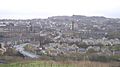
Skyline of Brierfield

See also
In Spanish: Brierfield para niños
