
Bryher facts for kids
Quick facts for kids Bryher
|
|
|---|---|
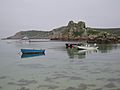
 Bryher seen from Tresco |
|

Bryher
|
|
| Population | 84 (2011) |
| OS grid reference | SV876361 |
| Civil parish |
|
| Unitary authority | |
| Ceremonial county | |
| Region | |
| Country | England |
| Sovereign state | United Kingdom |
| Post town | ISLES OF SCILLY |
| Postcode district | TR23 |
| Dialling code | 01720 |
| Police | Devon and Cornwall |
| Fire | Isles of Scilly |
| Ambulance | South Western |
| EU Parliament | South West England |
| UK Parliament |
|
Bryher is a small, beautiful island in the Isles of Scilly, which are a group of islands off the coast of Cornwall, England. Its name, Breyer, means "place of hills" in the Cornish language. It's one of the few islands in the Scilly group where people live all year round.
Contents
History of Bryher
The island's name, Bryher, has been around for a long time! It was first written down as Brayer in 1336 and later as Brear in 1500.
Exploring Bryher's Geography
Bryher is made up of several hills connected by lower areas and sandy beaches. If sea levels were to rise just a little, the southern part of Bryher would actually become five or six separate islands! The main hills are Gweal, Timmy's, Watch, Heathy, and Samson. These hills are very windy and open, so they aren't used for farming. Because of this, most of Bryher's 84 residents live in the sheltered areas between the hills and the coast.
The island is about 2 kilometers (1.2 miles) long and 1 kilometer (0.6 miles) wide. It covers an area of 134 hectares (331 acres). At its northern tip, Shipman Head rises to 42 meters (138 feet) high. Bryher is located to the west of Tresco. A channel called Tresco Channel separates them. This channel used to be a main spot for ships to anchor, but now it's an area where sandflats appear when the tide is low.
South of Bryher is the island of Samson, which no one lives on. When the tide is very low (called a spring tide), you can even walk between Bryher, Tresco, and Samson!
The settlement near the Pool and Hell Bay Hotel is the most western point in England. Bryher is one of the smallest inhabited islands in the Isles of Scilly, either by population or size, especially if you count Gugh as part of St Agnes.

The middle of Bryher is mostly flat, with fields for growing crops, pastures for animals, and houses where most people live. On the west side, there's a lake called Great Pool, which has slightly salty water. The Hell Bay Hotel overlooks this pool. In the south, you'll find beautiful sandy beaches, like Rushy Bay, which are common across the island.
Bryher is part of the Isles of Scilly Area of Outstanding Natural Beauty. The land that isn't owned by anyone is rented by the Duchy of Cornwall to the Isles of Scilly Wildlife Trust. This trust uses ponies and red ruby cattle to graze overgrown areas. This helps keep the natural plant life healthy as part of a project called Waves of Heath.
Hell Bay: A Notorious Cove

On the northwest coast of Bryher, you'll find the famous Hell Bay. This cove faces the wide Atlantic Ocean. In the 1700s and 1800s, it was known for many shipwrecks. However, most ships that wrecked in Scilly actually sank before they even reached Hell Bay.
Bryher's Local Government

Bryher is one of the five local government areas, called civil parishes, in the Isles of Scilly. These parishes are also known as wards. The Bryher parish includes other islands and rocks where no one lives, such as the Norrard Rocks, Gweal, Zantman's Rock, and the Crim Rocks (which are the westernmost point of England). Bryher elects one person to represent it on the Council of the Isles of Scilly.
Population Changes Over Time
Here's how the number of people living on Bryher has changed over the years:
|
|
|
|
|
|
Churches on Bryher
All Saints' Church
All Saints’ Church is a Church of England church located in the middle of the island, near the east coast. It faces New Grimsby on Tresco. The first church was built here around 1742, but it was completely rebuilt in 1821-1822. The church was updated again in 1860-1861, when the tower and porch were added. The front part of the church was changed in 1897-1898. In 1930, the roof was replaced and made taller. The main part of the church has four modern stained-glass windows created by Oriel Hicks.
Bryher Baptist Church


The Baptist faith arrived in Scilly in the early 1800s. The Baptist Itinerant Aid Society set up their first mission here, with chapels on all the islands where people lived, including Bryher. However, a local leader named Augustus Smith had disagreements with the Baptists, and in 1843, he had all their chapels closed. But a new Baptist chapel was built on Bryher in 1874. It was used for nearly 100 years before being turned into a private house in 1972.
Bryher’s Quays: Island Connections
Bryher has two quays, which are docks where boats can load and unload. Church Quay is used when the tide is high, and Bar Quay is used when the tide is low. These quays are very important for the boats that travel between the Scilly islands, carrying both people and goods.
Church Quay is, as its name suggests, near All Saints' Church. It's on a small piece of land called 'The Island' at the north end of Green Bay. There has been a quay here since at least the 1800s.
Bar Quay, also known as Anneka’s Quay, is north of Church Quay. It was first built in 1990 by volunteers for a TV show called Challenge Anneka. Many islanders still call it 'Anna Quay'.
The Duchy of Cornwall is in charge of both quays on Bryher.
Quay Renovation Project (2006-2008)
The quays on Bryher, along with those on St Agnes and St Martins, were part of a big £3.5 million renovation project by the Duchy of Cornwall between 2006 and 2008. The goal was to make them safer to use and easier to maintain.
For most of the quays on the smaller islands, a similar solution was used: new quay walls were built using pre-made concrete blocks. These blocks were strongly attached to the bedrock and connected to the old structures with concrete planks.
Anneka’s Quay was originally made of timber supported by sand-filled structures. During the renovation, it was made about 12 meters (39 feet) longer by adding two more concrete-filled structures. The old timber deck was replaced with a strong concrete slab.
BBC News reported on October 2, 2007, that it had been 50 years since any major work was done on the quays of the smaller islands before this project.
Education for Bryher's Children

The Five Islands Academy has a primary school campus, called the Tresco and Bryher Base, located on Tresco. Primary school students from Bryher travel to Tresco every day for school.
For secondary school, students from Bryher live at the main campus on St Mary's during the weekdays. They stay there and then return to their home islands on weekends.
Students who go on to college after secondary school (called sixth-form college) usually live and study on mainland Great Britain.
Bryher's Amazing Natural World
Bryher is home to three special areas called Sites of Special Scientific Interest (SSSIs). These are places protected because of their unique wildlife or geology.
Shipman Head and Shipman Down SSSI
This SSSI was first protected in 1971 and covers over 40 hectares (99 acres) at the northern end of the island. Here, you'll find a type of plant community called waved maritime heath growing on thin soils over granite rock. Some rare plants found here include the Orange Bird's-foot and the Hairy Bird's-foot trefoil. You can also spot interesting lichens like Lobaria pulmonaria and Teleoschistes flavicans.
Great Pool SSSI
On the west side of the island is Great Pool, which is part of the Pool of Bryher and Popplestone Bank SSSI. This pool is separated from the sea by a natural barrier of rocks and sand dunes. It's the only natural lake on Scilly with slightly salty water. Plants like Saltmarsh Rush and Beaked Tasselweed grow here.
Rushy Bay and Heathy Hill SSSI
This SSSI covers 12 hectares (30 acres) in the southern part of the island and has several plants that are rare in the UK. A special plant found only in the Isles of Scilly is the Dwarf Pansy. Thousands of these tiny flowers can be seen in May in short grass and bare sand on Bryher. Unfortunately, a storm in 2008 reduced their numbers. Small groups of them also grow on Tresco and Teän. Other rare plants like Orange Bird's-foot, Small Adder's-tongue, and Autumn's Lady's-tresses grow on Heathy Hill.
Birds that Live and Breed Here
Shipman Head is a nesting place for seven types of seabirds:
- Kittiwake
- Herring Gull
- Greater Black-backed Gull
- Lesser Black-backed Gull
- Razorbill
- Shag
- European Storm Petrel
Ringed Plovers also build their nests on Shipman Down.
Visiting Bryher Island
Bryher offers different places to stay, including guesthouses and self-catering cottages spread across the island. There's also a campsite near the northern end, with views of both coasts. The Hell Bay Hotel is located close to the coast on the west side.
Boats use the two quays (depending on the tide) to take visitors between Bryher and other islands, such as St Mary's and Tresco. When the tide is very low, you can even walk between Bryher, Tresco, and Samson, the uninhabited island to the south. Small yachts can also safely anchor in the channel and Green Bay.
Popular activities on the island include boating, walking, and watching the amazing wildlife.
Bryher in Culture and Media
Bryher on Film and TV
In 1989, parts of the BBC's TV show The Voyage of the Dawn Treader were filmed on Bryher.
The movie Why the Whales Came was also filmed on the island in 1989. It starred famous actors like Helen Mirren, Helen Pearce, Paul Scofield, and David Suchet.
Bryher in Books

Bryher appears in several books:
- The Wreck of the Zanzibar
- The Sleeping Sword
- Why the Whales Came
- Listen to the Moon
All these books were written by Michael Morpurgo. Other books featuring Bryher include Hell Bay by Sam Llewellyn and The Old Success by Martha Grimes.
"Bryher" as a Name
Annie Winifred Ellerman, whose father Sir John Ellerman was one of the wealthiest men in the UK, chose the name Bryher as her writing name (or pen name) in the early 1900s.
Images for kids
-
A view of Bryher

