
Burnt Boot Peak facts for kids
Quick facts for kids Burnt Boot Peak |
|
|---|---|

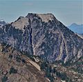
Burnt Boot Peak, south aspect
|
|
| Highest point | |
| Elevation | 6,520 ft (1,990 m) |
| Prominence | 1,000 ft (300 m) |
| Isolation | 1.33 mi (2.14 km) |
| Parent peak | Overcoat Peak (7,432 ft) |
| Geography | |

Burnt Boot Peak
Location in Washington (state)

Burnt Boot Peak
Location in the United States
|
|
| Location | King County, Washington state, U.S. |
| Parent range | Cascade Range |
| Topo map | USGS Big Snow Mountain |
| Climbing | |
| First ascent | 1963 |
| Easiest route | Scrambling |
Burnt Boot Peak is a mountain in Washington state, standing about 6,520 feet (1,987 meters) tall. It is located in the beautiful Alpine Lakes Wilderness in King County. This peak is part of the Cascade Range, a large mountain chain. It sits just one mile east of the main ridge of the Cascades.
Burnt Boot Peak is about 6.5 miles (10.5 km) northeast of Snoqualmie Pass. The land around it is managed by the Mount Baker-Snoqualmie National Forest. Nearby mountains include Huckleberry Mountain to the south and Lemah Mountain to the east. Even though it's a big mountain, Burnt Boot Peak doesn't have an official name! It's located at the start of a creek called Burnboot Creek (sometimes spelled Burntboot Creek). Rain and melting snow from the mountain flow into this creek or into the Middle Fork Snoqualmie River.
The first people to climb Burnt Boot Peak were Phil Weiser and Clarke Stockwell in August 1963. Another group, Don Williamson, Tom Oas, and Bill Bucher, climbed it using the north ridge route in June 1971.
Mountain Weather and Climate
Burnt Boot Peak is in a special marine west coast climate zone. This means it gets a lot of moisture from the Pacific Ocean. Most weather systems start over the Pacific and move towards the Cascade Range.
When these weather systems hit the tall Cascade Mountains, they are forced to rise. As the air goes higher, it cools down and drops its moisture as rain or snow. This process is called Orographic lift. Because of this, the western side of the Cascades gets a lot of rain and snow, especially in winter.
In winter, the weather is often cloudy. But in summer, high-pressure systems over the Pacific Ocean usually bring clear skies. The snow in this area tends to be wet and heavy due to the ocean's influence. This can sometimes lead to a high risk of avalanches. The best time to visit or climb Burnt Boot Peak is usually from July through September, when the weather is most favorable.
How the Mountains Were Formed
The Alpine Lakes Wilderness, where Burnt Boot Peak is located, has very rugged land. You can see sharp peaks, long ridges, deep valleys carved by glaciers, and tall granite walls. There are also over 700 mountain lakes scattered around! All these different features and big changes in elevation were created by geological events that happened millions of years ago.
The Cascade Range began forming a very long time ago, in the late Eocene Epoch. This was when the North American Plate slowly moved over the Pacific Plate. This movement caused a lot of volcanic activity, which helped build the mountains. Also, small pieces of the Earth's crust, called terranes, joined together to form the North Cascades about 50 million years ago.
Later, during the Pleistocene period (which started over two million years ago), huge sheets of ice called glaciers moved across the land many times. These glaciers carved and shaped the landscape, creating the "U"-shaped valleys you see today. The last time glaciers retreated from the Alpine Lakes area was about 14,000 years ago. The combination of the land pushing upwards (orogeny) and cracks in the Earth's crust (faulting), along with the glaciers, created the tall peaks and deep valleys of the Alpine Lakes Wilderness.
Images for kids
-
South aspect, from Alta Mountain
-
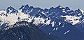
Burn Boot Peak centered, west aspect as seen from Preacher Mountain. Overcoat Peak, Chimney Rock, and Lemah Mountain in the background


