
Preacher Mountain facts for kids
Quick facts for kids Preacher Mountain |
|
|---|---|

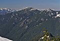
Preacher Mountain seen from Middle Fork Snoqualmie River Road
|
|
| Highest point | |
| Elevation | 5,924 ft (1,806 m) |
| Prominence | 844 ft (257 m) |
| Geography | |

Preacher Mountain
Location in Washington (state)

Preacher Mountain
Location in the United States
|
|
| Parent range | Cascade Range |
| Topo map | USGS Bandera |
| Climbing | |
| Easiest route | Scrambling |
Preacher Mountain is a big mountain peak in King County, Washington state. It sits on the western edge of the Cascade Range and is part of the beautiful Alpine Lakes Wilderness. This area is looked after by the Mount Baker-Snoqualmie National Forest.
The closest taller mountain is Kaleetan Peak, about 3.11 miles (5 km) to the southeast. Another peak called The Pulpit is about 2.19 miles (3.5 km) to the northwest. Rain and snow that fall on Preacher Mountain flow into streams that feed the Snoqualmie River.
Mountain Weather
Preacher Mountain is in a special climate zone found in western North America. This means it gets a lot of moisture from the Pacific Ocean. Most weather fronts, which bring changes in weather, come from the Pacific. They travel northeast towards the Cascade Mountains.
When these weather fronts hit the tall Cascade Mountains, they are forced to rise. As the air goes up, it cools down and drops its moisture. This causes a lot of rain or snowfall on the western side of the Cascades. This process is called Orographic lift.
Because of this, the west side of the Cascades gets a lot of precipitation, especially in winter. Winters are usually cloudy. However, in summer, high pressure systems over the Pacific Ocean often bring clear skies. The snow here tends to be wet and heavy because of the ocean's influence. This can sometimes lead to a high risk of avalanches.

How the Mountains Formed
The Alpine Lakes Wilderness has some really rugged land. You can see jagged peaks, sharp ridges, deep valleys carved by glaciers, and tall granite walls. There are also more than 700 mountain lakes scattered around.
The amazing landscape and big changes in elevation in the Cascade Range were created by geological events that happened millions of years ago. These changes also led to different climates and types of plants in various ecoregions.
The Cascade Mountains started forming millions of years ago, during the late Eocene Epoch. At that time, the North American Plate was slowly moving over the Pacific Plate. This movement caused many periods of volcanic activity. Also, small pieces of the Earth's crust, called terranes, helped form the North Cascades about 50 million years ago.
During the Pleistocene period, which was over two million years ago, huge sheets of ice called glaciers moved across the land many times. As they moved, they scraped and shaped the landscape, leaving behind rock debris. The last time glaciers retreated from the Alpine Lakes area was about 14,000 years ago. The "U"-shaped valleys you see today were carved out by these recent glaciers. The rising of the land (orogeny) and cracks in the Earth's crust (faulting), along with glaciation, have been the main forces that created the tall peaks and deep valleys of the Alpine Lakes Wilderness.
Images for kids
-
South aspect, from Mount Defiance

