Caldwell County, Kentucky facts for kids
Quick facts for kids
Caldwell County
|
|
|---|---|

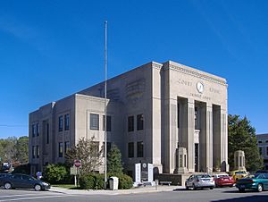
Caldwell County courthouse in Princeton
|
|

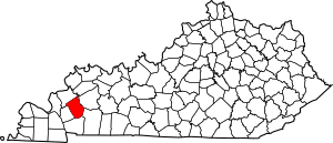
Location within the U.S. state of Kentucky
|
|
 Kentucky's location within the U.S. |
|
| Country | |
| State | |
| Founded | 1809, 1809 |
| Named for | John Caldwell |
| Seat | Princeton |
| Largest city | Princeton |
| Area | |
| • Total | 348 sq mi (900 km2) |
| • Land | 345 sq mi (890 km2) |
| • Water | 3.4 sq mi (9 km2) 1.0%% |
| Population
(2020)
|
|
| • Total | 12,649 |
| • Estimate
(2023)
|
12,551 |
| • Density | 36.35/sq mi (14.034/km2) |
| Time zone | UTC−6 (Central) |
| • Summer (DST) | UTC−5 (CDT) |
| Congressional district | 1st |
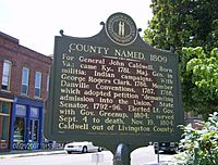
Caldwell County is a county located in the U.S. state of Kentucky. In 2020, about 12,649 people lived there. Its main town, called the county seat, is Princeton. The county was created in 1809 from Livingston County, Kentucky. It was named after John Caldwell. He was a brave leader who helped in a campaign against Native American groups in 1786. He also became the second lieutenant governor of Kentucky. For many years, Caldwell County was a "dry county," meaning alcohol sales were banned. But in 2013, citizens voted to allow alcohol sales again.
Contents
History of Caldwell County
Caldwell County was formed from Livingston County in 1809. Before that, this area was part of other counties. These included Christian, Logan, and Lincoln Counties. Lincoln County was one of Kentucky's first three counties.
In the early 1800s, a sad event happened in Caldwell County. Many Cherokee people were forced to move from their homes to the West. This journey is known as the Trail of Tears. In the winter of 1838, Cherokee families camped in Caldwell County for several weeks. They stayed at places like Big Springs in Princeton and near Fredonia.
In 1860, work started on Princeton College. However, the Civil War stopped the building. Caldwell County strongly supported the Confederate side. In 1861, Confederate soldiers camped at Princeton College. They even used one building as a hospital. After the Confederates left in early 1862, Union soldiers took over Princeton. They stayed there for the rest of the war. In December 1864, Confederate cavalry burned the Caldwell County courthouse. This was because Union soldiers were using it as a base.
Later in the 1800s, railroads grew in the area. This made Princeton an important stop for trains. Major lines like the Illinois Central and the Louisville & Nashville passed through.
Around 1900, farming became very important. Caldwell County, along with Christian County, grew a lot of a special kind of tobacco. This area was called the "Black Patch." Farmers used a unique way to dry the tobacco. But a company called the American Tobacco Company controlled the tobacco market. This made prices very low, and many farmers struggled.
To fight this, farmers formed a group called the Planters' Protective Association (PPA). They wanted to work together to get better prices for their tobacco. At first, they tried to convince other farmers to join them.
Later, a group called the Night Riders was formed. They were led by Dr. David Amoss. This group used strong methods to make farmers join the PPA. They destroyed crops and burned warehouses. In December 1906, the Night Riders took over Princeton for one night. They burned all the tobacco warehouses owned by the big company. These events were part of what was called the "Black Patch Wars." The state militia eventually helped to stop the fighting around 1908.
Since 1925, Caldwell County has been home to the University of Kentucky Research and Education Center (UKREC). This center is part of the University of Kentucky's College of Agriculture. The UKREC in Princeton is a leader in studying plants and biology.
In the middle of the 1900s, Caldwell County started to change. It moved from being mostly farms to having more factories. Caldwell County still has a lot of farms. But it also has factories, like Bremner, which makes cookies and crackers.
Geography of Caldwell County
Caldwell County covers about 348 square miles. Most of this area, about 345 square miles, is land. The rest, about 3.4 square miles, is water.
Neighboring Counties
- Crittenden County (to the northwest)
- Webster County (to the northeast)
- Hopkins County (to the northeast)
- Christian County (to the southeast)
- Trigg County (to the south)
- Lyon County (to the southwest)
Population Information
| Historical population | |||
|---|---|---|---|
| Census | Pop. | %± | |
| 1810 | 4,268 | — | |
| 1820 | 9,022 | 111.4% | |
| 1830 | 8,324 | −7.7% | |
| 1840 | 10,365 | 24.5% | |
| 1850 | 13,048 | 25.9% | |
| 1860 | 9,318 | −28.6% | |
| 1870 | 10,826 | 16.2% | |
| 1880 | 11,282 | 4.2% | |
| 1890 | 13,186 | 16.9% | |
| 1900 | 14,510 | 10.0% | |
| 1910 | 14,063 | −3.1% | |
| 1920 | 13,975 | −0.6% | |
| 1930 | 13,781 | −1.4% | |
| 1940 | 14,499 | 5.2% | |
| 1950 | 13,199 | −9.0% | |
| 1960 | 13,073 | −1.0% | |
| 1970 | 13,179 | 0.8% | |
| 1980 | 13,473 | 2.2% | |
| 1990 | 13,232 | −1.8% | |
| 2000 | 13,060 | −1.3% | |
| 2010 | 12,984 | −0.6% | |
| 2020 | 12,649 | −2.6% | |
| 2023 (est.) | 12,551 | −3.3% | |
| U.S. Decennial Census 1790-1960 1900-1990 1990-2000 2010-2021 |
|||
In 2000, Caldwell County had 13,060 people. The population density was about 38 people per square mile. Most people in the county were White (93.89%). About 4.81% were Black or African American. A small number of people were from other racial backgrounds.
Towns and Communities
Cities
- Dawson Springs (mostly in Hopkins County)
- Fredonia
- Princeton (the county seat)
Smaller Communities
- Bakers
- Baldwin Ford
- Black Hawk
- The Bluff
- Bucksnort
- Cedar Bluff
- Claxton
- Cobb
- Cresswell
- Crider
- Crowtown
- Dulaney
- Enon
- Farmersville
- Flat Rock
- Friendship
- Fryer
- Harper Ford
- Hopson
- Lake Shore
- Lewistown
- McGowan
- Midway
- Needmore
- Otter Pond
- Pumpkin Center
- Quinn
- Rufus
- Scottsburg
- Smith Ford
- Tom Gray Ford
- Walche Cut
- White Sulphur
Education in Caldwell County
The main school districts in the county are:
- Caldwell County School District
- Dawson Springs Independent School District
See also
 In Spanish: Condado de Caldwell (Kentucky) para niños


