Carne Mountain facts for kids
Quick facts for kids Carne Mountain |
|
|---|---|

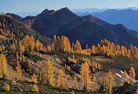
Carne Mountain from the north
|
|
| Highest point | |
| Elevation | 7,080 ft (2,160 m) |
| Prominence | 480 ft (150 m) |
| Isolation | 1.38 mi (2.22 km) |
| Parent peak | Chilly Peak (7,960 ft) |
| Geography | |
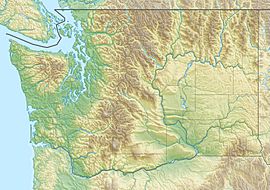
| Location | Chelan County Washington, U.S. |
| Parent range | Entiat Mountains North Cascades Cascade Range |
| Topo map | USGS Trinity |
| Climbing | |
| Easiest route | class 2 hiking |
Carne Mountain is a tall mountain in Washington state. It has two peaks and stands 7,080 feet (2,158 meters) high. You can find it in the Entiat Mountains, which are part of the larger North Cascades. This mountain is located in Chelan County, Washington.
Carne Mountain is on the edge of the Glacier Peak Wilderness area. The Okanogan-Wenatchee National Forest manages the land around it. Its closest taller neighbor is Chilly Peak, about 1.4 miles (2.3 km) away. Another peak called Ice Box is 1.7 miles (2.7 km) to the north.
Rain and melting snow from the mountain flow into Rock Creek or Phelps Creek. Both of these streams eventually join the Chiwawa River. You can hike to Carne Mountain using the 3.7-mile Carne Mountain Trail. This trail climbs 3,600 feet (1,097 meters) in elevation.
Long ago, there was a fire lookout building on the mountain's south peak. From the top, you can see many other peaks. These include Bandit Peak, Brahma Peak, Buck Mountain, Fortress Mountain, Chiwawa Mountain, Mount Maude, Ice Box, and Chilly. Albert Hale Sylvester named this mountain after an English clergyman, W. Stanely Carnes. The name is pronounced "karn".
Weather Around Carne Mountain
Carne Mountain is located east of the Cascade Range. This means the area is a bit drier than places to the west. In summer, it can be warm, and sometimes there are thunderstorms.
Most weather systems come from the Pacific Ocean. They travel northeast towards the Cascade Mountains. When these weather systems reach the North Cascades, the tall peaks force the air upward. This process is called Orographic lift. As the air rises, it cools and drops its moisture as rain or snow.
Because of this, the North Cascades gets a lot of rain and snow. This is especially true during the winter months. Carne Mountain is very tall, so it can have snow on its peaks in late spring and early fall. It can also be very cold there in the winter.
How Carne Mountain Formed
The North Cascades has very rugged land. It features sharp peaks, long ridges, and deep valleys carved by glaciers. Many millions of years ago, big geological events happened. These events created the varied landscape and huge changes in elevation. These changes also led to different climates and types of plants in the area.
The Cascade Range began forming millions of years ago, during the late Eocene Epoch. The North American Plate was slowly moving over the Pacific Plate. This movement caused many volcanic eruptions. Glacier Peak, a large volcano, started forming about 14.5 miles (23.3 km) west of Carne Mountain. This happened in the mid-Pleistocene period.
During the Pleistocene period, which was over two million years ago, glaciers moved across the land many times. As they advanced and retreated, they scraped away the landscape. They left behind piles of rock and debris. The valleys you see today often have a "U" shape. This shape was created by these ancient glaciers.
The main forces that shaped the tall peaks and deep valleys of the North Cascades were uplift (when land pushes upward) and faulting (when cracks form in the Earth's crust). These forces, combined with the action of glaciers, created the dramatic scenery we see today.
 | Aurelia Browder |
 | Nannie Helen Burroughs |
 | Michelle Alexander |


