
Schoharie, New York facts for kids
Quick facts for kids
Schoharie, New York
|
|
|---|---|

Schoharie County Courthouse
|
|

Location in Schoharie County and the state of New York.
|
|
| Country | United States |
| State | New York |
| County | Schoharie |
| Settled | 1718 |
| Established | 1788 |
| Area | |
| • Total | 29.96 sq mi (77.60 km2) |
| • Land | 29.83 sq mi (77.26 km2) |
| • Water | 0.13 sq mi (0.33 km2) 0.57% |
| Elevation | 604 ft (184 m) |
| Population
(2020)
|
|
| • Total | 3,107 |
| Time zone | UTC-5 (Eastern (EST)) |
| • Summer (DST) | UTC-4 (EDT) |
| ZIP code |
12157
|
| Area code(s) | 518 |
| FIPS code | 36-65596 |
| GNIS feature ID | 0979470 |
Schoharie (/skoʊˈhɛəriː/ skoh-HAIR-ee) is a town in Schoharie County, New York, United States. It is also the main town, or county seat, of Schoharie County. In 2020, about 3,107 people lived there.
The name "Schoharie" comes from a Mohawk word meaning "driftwood." There is also a village called Schoharie within the town. The town is located southwest of Albany and northeast of Oneonta and Cooperstown. It is about 170 miles (273 km) north of NYC.
Contents
History of Schoharie
This area was originally home to indigenous peoples. The Mohawk people, part of the Haudenosaunee (Iroquois Confederacy), lived here for a long time.
Early European Settlers
Even though the English claimed New York, the first European settlers in Schoharie were Palatine Germans. They arrived in 1713. These Germans were refugees who fled religious conflicts near France. They also faced a very cold winter in 1709, which ruined their crops.
About 3,000 German Protestants came to New York in 1710. Queen Anne's government helped them travel. The English hoped these settlers would help develop the colony. They gave them land west of the English settlements.
Many Palatine Germans first worked on Livingston Manor along the Hudson River. After a few years, they received their own land. In 1723, 100 Palatine families got land near Little Falls. They started farms and built new communities. You can still see their influence in names like German Flatts. These frontier settlements helped protect the colony during wars.
Schoharie During Wars
The Schoharie Valley was known for growing a lot of wheat. It was called a "bread basket" for the colony. During the American Revolutionary War, raids led by Joseph Brant and his Iroquois allies destroyed many buildings in Schoharie.
Town Formation and Growth
Schoharie was first a district in Albany County. In 1788, it became a town. Then, in 1795, it became the first town in the newly formed Schoharie County. Over time, parts of Schoharie were used to create other towns. These included Blenheim, Broome, Cobleskill, Middleburgh, Esperance, and Wright.
Schoharie has always been a farming community. In the 1800s, cheesemaking and dairy farming were very important. Products were sold all the way to New York City. Today, artisan cheesemaking is still a growing industry.
Recent Events
On August 28, 2011, Hurricane Irene caused major flooding in Schoharie. The Schoharie Creek rose to record levels. This led to a lot of damage to roads, homes, and businesses. Federal agencies like FEMA and the National Guard helped the affected residents. Many farms lost animals and crops.
In 2018, a serious vehicle accident happened in Schoharie. It resulted in the loss of 20 lives.
Historic Buildings
Several historic buildings in Schoharie are listed on the National Register of Historic Places. These include the Becker Stone House, Becker-Westfall House, The Colyer House, Sternbergh House, and Westheimer Site. The Abraham Sternberg House and Christian Hess House and Shoemaker's Shop were added more recently.
Geography of Schoharie
The Town of Schoharie covers about 30 square miles (77.6 km²). Most of this area is land, with a small amount of water.
Location and Roads
The northeast part of the town shares a border with Schenectady County.
Major roads cross through Schoharie:
- Interstate 88 runs through the northern part.
- New York State Route 30 is a main north-south highway.
- State Route 30A branches off from NY-30.
- State Route 7 runs parallel to Interstate 88.
- New York State Route 443 meets NY-30 at Vromans Corners.
Rivers and Creeks
The Schoharie Creek flows north through the town. It eventually joins the Mohawk River. The Cobleskill Creek also flows into Schoharie Creek near Old Central Bridge.
Population Information
| Historical population | |||
|---|---|---|---|
| Census | Pop. | %± | |
| 1820 | 3,820 | — | |
| 1830 | 5,146 | 34.7% | |
| 1840 | 5,534 | 7.5% | |
| 1850 | 2,588 | −53.2% | |
| 1860 | 3,090 | 19.4% | |
| 1870 | 3,207 | 3.8% | |
| 1880 | 3,350 | 4.5% | |
| 1890 | 2,944 | −12.1% | |
| 1900 | 2,700 | −8.3% | |
| 1910 | 2,526 | −6.4% | |
| 1920 | 2,132 | −15.6% | |
| 1930 | 2,193 | 2.9% | |
| 1940 | 2,417 | 10.2% | |
| 1950 | 2,777 | 14.9% | |
| 1960 | 3,063 | 10.3% | |
| 1970 | 3,088 | 0.8% | |
| 1980 | 3,107 | 0.6% | |
| 1990 | 3,369 | 8.4% | |
| 2000 | 3,299 | −2.1% | |
| 2010 | 3,205 | −2.8% | |
| 2020 | 3,107 | −3.1% | |
| U.S. Decennial Census | |||
In 2000, there were 3,299 people living in Schoharie. About 1,314 households and 883 families lived in the town. The population density was about 110.7 people per square mile.
Most residents (98.30%) were White. Other groups included Black or African American (0.36%), Native American (0.48%), and Asian (0.12%). About 0.97% of the population was Hispanic or Latino.
About 31.8% of households had children under 18. The average household had 2.47 people, and the average family had 3.01 people.
The population was spread out by age:
- 24.9% were under 18
- 7.6% were 18 to 24
- 25.9% were 25 to 44
- 26.6% were 45 to 64
- 14.9% were 65 or older
The average age was 40 years. For every 100 females, there were about 92.2 males.
The median income for a household was $38,576. For a family, it was $50,000. About 6.1% of the population lived below the poverty line.
Communities and Places in Schoharie
- Barton Hill – A place in the northeast part of Schoharie.
- Central Bridge – A small community (hamlet) on the northern town line. The George Westinghouse, Jr., Birthplace and Boyhood Home is located here.
- East Cobleskill – A hamlet on the western town line.
- Howes Cave – A hamlet on the western town line, north of Cobleskill Creek.
- Old Central Bridge – A hamlet in the northeast part of the town, near Interstate 88.
- Schoharie – The main village, located on NY Route 30 next to Schoharie Creek.
- Schoharie Hill – A raised area northwest of Schoharie village.
- Sidney Corners – A place in the northwest corner of the town.
- Terrace Mountain – A raised area northwest of Schoharie Village.
- Vroman Corners – A place north of Schoharie village, named after an early Dutch settler.
Notable People from Schoharie
- George Westinghouse – Born in Central Bridge in 1846. He was a famous inventor. He created the railway air brake and helped develop alternating current (AC) power.
- Chris Hedges – A well-known author who grew up in Schoharie. His father was a pastor there.
- Pete Lopez – A politician and New York Assemblyman. He lived in Schoharie for many years and served as the Town Supervisor.
Images for kids
-
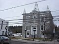
Schoharie County Courthouse
-
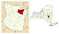
Location in Schoharie County and the state of New York.
See also
 In Spanish: Schoharie (Nueva York) para niños
