Central Lowlands facts for kids
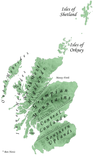
The Central Lowlands, also known as the Midland Valley or Central Valley, is a special area of land in southern Scotland. Imagine a giant valley! This region is like a long, relatively flat area nestled between two major cracks in the Earth's crust, called faults. To the north is the Highland Boundary Fault, and to the south is the Southern Uplands Fault. The Central Lowlands is one of Scotland's three main geographical parts, with the Highlands and Islands to the north and the Southern Uplands to the south. It's the most populated part of Scotland, meaning more people live here than anywhere else in the country!
Contents
Exploring Scotland's Central Lowlands
How the Land Was Formed: Geology
The ground beneath the Central Lowlands is made up of very old rocks, mostly from a time called the Paleozoic Era. Many of these sedimentary rocks are super important because they contain valuable resources like coal and iron. These resources were key to Scotland's Industrial Revolution, a time when factories and industries grew rapidly.
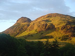
This area also saw a lot of volcanic activity long ago. For example, Arthur's Seat in Edinburgh is what's left of a much bigger volcano that was active about 300 million years ago during the Carboniferous period. Even though it's called "Lowlands," you can still see hills like the Ochils and Campsie Fells nearby. Like the rest of Scotland, this entire region was shaped by huge sheets of ice during the Pleistocene ice ages.
Earth's Moving Plates: Boundary Faults
The two main "cracks" or faults that define the Central Lowlands are very important. The Highland Boundary Fault stretches from the Isle of Arran in the southwest, through the Isle of Bute and Helensburgh, and then forms the northern edge of Strathmore before reaching Stonehaven in the northeast.
This fault was very active during a massive event called the Caledonian orogeny. This was a time, between 520 and 400 million years ago, when huge landmasses collided, like giant puzzle pieces of the Earth's crust. This collision caused the Midland Valley to sink down, creating a deep rift that could be as much as 4,000 meters deep! Over time, the land moved both up and down, and also slid sideways.
The Southern Uplands Fault is the other important boundary. It runs from the Rhins of Galloway in the west all the way to Dunbar on the east coast, which is about 30 kilometers (19 miles) from Edinburgh.
Where People Live: Human Geography
The Central Lowlands has a great combination of things that make it a popular place to live. The land is fertile, which means it's good for farming. Plus, it has those important deposits of coal and iron. These natural advantages led to the Central Lowlands becoming much more densely populated than other parts of Scotland.
Many of Scotland's biggest and most important cities are located here, including Glasgow, Edinburgh, Dunfermline, Stirling, Perth, and Dundee. In fact, more than 75% of all the people in Scotland live in this region!
See also
- Central Scotland (disambiguation)
- Geology of Scotland
- Scottish Lowlands
 | Toni Morrison |
 | Barack Obama |
 | Martin Luther King Jr. |
 | Ralph Bunche |


