
Cherokee, North Carolina facts for kids
Quick facts for kids
Cherokee, North Carolina
ᏣᎳᎩ (Cherokee),
ᎡᎳᏬᏗ (Elawodi) |
|
|---|---|

Tsalagi Road
|
|
| Motto(s):
"Trails of Legends and Adventures"
|
|
| Country | United States |
| State | North Carolina |
| Counties | Swain and Jackson |
| Area | |
| • Total | 12.07 sq mi (31.26 km2) |
| • Land | 12.07 sq mi (31.26 km2) |
| • Water | 0.00 sq mi (0.00 km2) |
| Elevation | 2,438 ft (743 m) |
| Population
(2020)
|
|
| • Total | 2,195 |
| • Density | 181.84/sq mi (70.21/km2) |
| Time zone | UTC−5 (Eastern (EST)) |
| • Summer (DST) | UTC−4 (EDT) |
| ZIP code |
28719
|
| Area code(s) | 828 |
| FIPS code | 37-12140 |
| GNIS feature ID | 2629369 |
Cherokee (pronounced like "CHAIR-uh-kee") is a special community in Western North Carolina, United States. It's located in the beautiful Oconaluftee River Valley. This area is part of the Qualla Boundary, which is land owned by the Eastern Band of Cherokee Indians.
Cherokee is the main town for the Eastern Band of Cherokee Indians. This is one of three recognized Cherokee tribes in the United States. It is the only one located in North Carolina. In 2020, about 2,195 people lived here.
The community is a popular place for tourists to visit. Many people come to explore the Great Smoky Mountains National Park, which has a big entrance right in Cherokee. You can find lots of places to stay, like campgrounds and hotels. The Oconaluftee River flows through the town, and it's a great spot for tubing.
Contents
History of the Cherokee People
Cherokee is the capital of the Eastern Band of Cherokee Indians. This area has been home to the Cherokee people for a very long time. In the 1870s, the Eastern Band bought the land that is now called the "Qualla Boundary."
To keep their heritage alive, many street and building signs in Cherokee are written in two languages. You will see them in both the Cherokee syllabary (the Cherokee writing system) and English. The community of Cherokee covers parts of three important areas within the Qualla Boundary: Painttown, Wolftown, and Yellowhill.
Exploring Cherokee's Geography
Cherokee and the surrounding Qualla Boundary are in a very mountainous region. They are located in Swain and Jackson counties. The highest point nearby is Kuwohi, which is about 6,643 feet tall. Kuwohi is also the highest point in the Great Smoky Mountains National Park. The Oconaluftee River flows right through the center of Cherokee.
Who Lives in Cherokee?
| Historical population | |||
|---|---|---|---|
| Census | Pop. | %± | |
| 2010 | 2,138 | — | |
| 2020 | 2,195 | 2.7% | |
| U.S. Decennial Census | |||
Population in 2020
In 2020, there were 2,195 people living in Cherokee. There were 867 households and 561 families. Most of the people living in Cherokee are Native American.
| Group | Number of People | Percentage |
|---|---|---|
| Native American | 1,643 | 74.85% |
| White (not Hispanic) | 206 | 9.38% |
| Hispanic or Latino | 148 | 6.74% |
| Other/Mixed | 151 | 6.88% |
| Asian | 27 | 1.23% |
| Black or African American (not Hispanic) | 20 | 0.91% |
Cherokee's Climate
| Climate data for Cherokee, North Carolina, 1991–2020 normals | |||||||||||||
|---|---|---|---|---|---|---|---|---|---|---|---|---|---|
| Month | Jan | Feb | Mar | Apr | May | Jun | Jul | Aug | Sep | Oct | Nov | Dec | Year |
| Mean daily maximum °F (°C) | 46.3 (7.9) |
50.6 (10.3) |
58.6 (14.8) |
68.0 (20.0) |
74.7 (23.7) |
80.1 (26.7) |
82.7 (28.2) |
82.0 (27.8) |
77.9 (25.5) |
68.8 (20.4) |
58.3 (14.6) |
49.2 (9.6) |
66.4 (19.1) |
| Daily mean °F (°C) | 36.4 (2.4) |
39.6 (4.2) |
46.4 (8.0) |
55.2 (12.9) |
62.9 (17.2) |
69.6 (20.9) |
72.7 (22.6) |
71.7 (22.1) |
66.4 (19.1) |
55.9 (13.3) |
45.9 (7.7) |
39.2 (4.0) |
55.2 (12.9) |
| Mean daily minimum °F (°C) | 26.4 (−3.1) |
28.7 (−1.8) |
34.2 (1.2) |
42.3 (5.7) |
51.2 (10.7) |
59.1 (15.1) |
62.8 (17.1) |
61.4 (16.3) |
55.0 (12.8) |
43.0 (6.1) |
33.4 (0.8) |
29.3 (−1.5) |
43.9 (6.6) |
| Average precipitation inches (mm) | 4.74 (120) |
5.00 (127) |
5.84 (148) |
4.93 (125) |
4.71 (120) |
5.13 (130) |
5.21 (132) |
4.21 (107) |
4.04 (103) |
3.06 (78) |
4.18 (106) |
5.66 (144) |
56.71 (1,440) |
| Average snowfall inches (cm) | 2.6 (6.6) |
0.9 (2.3) |
0.9 (2.3) |
0.0 (0.0) |
0.0 (0.0) |
0.0 (0.0) |
0.0 (0.0) |
0.0 (0.0) |
0.0 (0.0) |
0.0 (0.0) |
0.1 (0.25) |
2.0 (5.1) |
6.5 (17) |
| Average precipitation days (≥ 0.01 in) | 10.6 | 10.8 | 11.9 | 10.4 | 12.2 | 11.8 | 14.0 | 12.4 | 9.4 | 7.7 | 8.9 | 11.1 | 131.2 |
| Average snowy days (≥ 0.1 in) | 1.4 | 1.2 | 0.6 | 0.0 | 0.0 | 0.0 | 0.0 | 0.0 | 0.0 | 0.0 | 0.1 | 0.7 | 4.0 |
| Source: NOAA | |||||||||||||
Cherokee's Economy
The Eastern Band of Cherokee Indians (EBCI) worked with the state to open Harrah's Cherokee Casino in 1997. This casino has created many jobs and brings in money for the tribe. The money helps fund education, welfare, and cultural programs for the Cherokee people.
In 2005, almost four million people visited the casino. This created a profit of about $8,000 per person in the tribe each year. Each tribal member gets some money annually. The tribe also uses money to pay for health services and long-term projects.
In the past, many factories left the area, which caused job losses. Many Cherokee people then relied on jobs related to tourism. These jobs often lasted only about half the year.
Fun Things to Do in Cherokee
Cherokee is a great place for tourists. It's located right at the entrance to Great Smoky Mountains National Park. It's also at the southern end of the Blue Ridge Parkway, a scenic road. Besides the casino, there are many other cool attractions:
- Cherokee Botanical Garden and Nature Trail: Explore beautiful plants and nature.
- Trail to Mount Guyot: A path leading to a mountain peak.
- Museum of the Cherokee Indian: Learn about Cherokee history and culture.
- Oconaluftee Indian Village: A living-history museum showing how the Cherokee lived in the 1750s.
- Qualla Arts & Crafts Mutual: See and buy amazing traditional Cherokee crafts.
- Oconaluftee River: Enjoy tubing or fishing in the river.
You can also watch Unto These Hills, a historical play about Eastern Cherokee history. It's performed every year during the tourist season. The Cherokee area has many campgrounds, hiking trails, and river adventures.
There are also a few roadside attractions with zoos, like Cherokee Bear Zoo and Chief Saunooke Bear Park. These zoos have been a topic of discussion.
Famous People from Cherokee
Many talented people have come from Cherokee:
- Walker Calhoun – A musician, dancer, and teacher.
- Amanda Crowe – A skilled woodcarver and educator.
- Raymond Fairchild – A famous banjo player.
- Charles George – A brave soldier who received the Medal of Honor.
- Edwin George - A folk artist known for his murals.
- Leon Miller – An American football player and lacrosse coach.
- Clyde Moody – A well-known bluegrass musician.
- Stan Powell – An NFL player for the Oorang Indians team.
Learning in Cherokee
Cherokee Central Schools runs the public schools for students from kindergarten to 12th grade. Cherokee High School is the local high school.
There is also a private elementary school called New Kituwah Academy. At this school, students learn by being fully immersed in the Cherokee language. This helps them become fluent speakers. In the past, students were not allowed to speak Cherokee in schools run by the Bureau of Indian Affairs.
Cherokee in the News
The Cherokee One Feather is a local newspaper. It has been serving the community for many years, sharing news and stories.
Images for kids
-
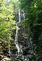
Mingo Falls near Cherokee drops about 120 feet.
-
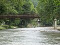
A walking bridge over the Oconaluftee River in Cherokee.
-
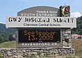
Cherokee Central Schools sign, showing the Cherokee syllabary.
-
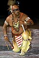
A member of the Warriors of AniKituhwa, a traditional Eastern Cherokee dance group.
-
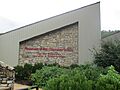
The Museum of the Cherokee Indian.
-
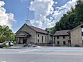
Cherokee Baptist Church.


See also
 In Spanish: Cherokee (Carolina del Norte) para niños
