
Chiang Mai province facts for kids
Quick facts for kids
Chiang Mai
เชียงใหม่
ᨩ᩠ᨿᨦᩉᩲ᩠ᨾ᩵
|
|||
|---|---|---|---|
| จังหวัดเชียงใหม่ · ᨧᩢ᩠ᨦᩉ᩠ᩅᩢᨩ᩠ᨿᨦᩉᩲ᩠ᨾ᩵ | |||
|
From left to right, top to bottom : Wat Phra That Doi Suthep, Doi Inthanon, Doi Ang Khang, Op Luang National Park, Wat Phra Singh, Chiang Mai University, Mae Sa Waterfall, Chiang Mai Zoo
|
|||
|
|||
| Motto(s):
"ดอยสุเทพเป็นศรี ประเพณีเป็นสง่า บุปผชาติล้วนงามตา นามล้ำค่านครพิงค์" ('Doi Suthep is Sri, Tradition is elegant, Beautiful blossoms and Invaluable name of Nakornping')
|
|||

|
|||
| Founded by | Mangrai | ||
| Capital | Chiang Mai | ||
| Area | |||
| • Total | 20,107 km2 (7,763 sq mi) | ||
| Area rank | 2nd | ||
| Population
(2022)
|
|||
| • Total | 1,792,474 | ||
| • Rank | Ranked 4th | ||
| • Density | 81/km2 (210/sq mi) | ||
| • Density rank | Ranked 63rd | ||
| Human Achievement Index | |||
| • HAI (2017) | 0.6159 "somewhat high" Ranked 21st |
||
| Time zone | UTC+7 (ICT) | ||
| Postal code |
50xxx
|
||
| Calling code | 052 & 053 | ||
| ISO 3166 code | TH-50 | ||
| Vehicle registration | เชียงใหม่ | ||
| Accession into Siam (Thailand) | 1910 | ||


.jpg)


| Chiang Mai province | |
|---|---|

"Chiang Mai" in Thai language (top) and
Northern Thai with Tai Tham script (bottom) |
|
| Thai name | |
| Thai | เชียงใหม่ |
| RTGS | Chiang Mai |
| Northern Thai name | |
| Northern Thai | ᨩ᩠ᨿᨦᩉᩲ᩠ᨾ᩵ [t͡ɕia̯ŋ.màj] |
Chiang Mai is the largest province in Thailand. It is located in the northern part of the country. About 1.78 million people live there. Chiang Mai province shares borders with other Thai provinces like Chiang Rai and Mae Hong Son. It also borders Shan State in Burma to the north. The capital city, also called Chiang Mai, is about 685 kilometers (426 miles) north of Bangkok.
Contents
- Exploring Chiang Mai's Geography
- Chiang Mai's Climate
- A Look at Chiang Mai's History
- People of Chiang Mai: Demographics
- Religion in Chiang Mai
- Symbols of Chiang Mai Province
- How Chiang Mai is Organized
- Human Achievement Index 2017
- Getting Around: Transportation in Chiang Mai
- Visiting Chiang Mai: Tourism
- Health Services
- Local Products and Crafts
- Chiang Mai's Local Culture
- Sports in Chiang Mai
- Sister Cities Around the World
- Notable People from Chiang Mai
- Images for kids
- See also
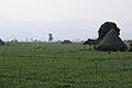
Exploring Chiang Mai's Geography
Chiang Mai province is about 685 kilometers (426 miles) from Bangkok. It sits in the Mae Ping River basin. The average height above sea level is 300 meters (984 feet). The province is surrounded by the Thai highlands mountains. It covers an area of about 22,135 square kilometers (8,546 square miles).
Mountains and Rivers
- The Daen Lao Range is in the north.
- The Thanon Thong Chai Range runs north to south. This range includes Doi Inthanon, Thailand's highest mountain at 2,565 meters (8,415 feet).
- The Khun Tan Range is in the east.
- These mountains are covered by rain forest.
- The Mae Ping River starts in the Daen Lao mountains. It is a main river that flows into the Chao Phraya River.
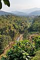
National Parks in Chiang Mai
Chiang Mai province has many beautiful national parks. These parks help protect nature and wildlife. There are fifteen national parks in the province, including:
- Doi Inthanon
- Doi Suthep-Pui
- Ob Luang
- Sri Lanna
- Huai Nam Dang
- Mae Wang
- Pha Daeng
About 69.6 percent of the province is covered by forests.
Wildlife Sanctuaries
Chiang Mai also has four important wildlife sanctuaries:
- Omkoi Wildlife Sanctuary
- Chiang Dao Wildlife Sanctuary
- Mae Lao–Mae Sae Wildlife Sanctuary
- Samoeng Wildlife Sanctuary
Chiang Mai's Climate
Chiang Mai has a tropical wet and dry climate. This means it has a rainy season and a dry season. The weather is warm to hot all year. During the dry season, nights can be cool. The highest temperature ever recorded was 42.4°C (108.3°F) in May 2005.
A Look at Chiang Mai's History
The city of Chiang Mai was founded in 1296. It became the capital of the Lanna Kingdom. This happened around the same time the Sukhothai Kingdom was established. Chiang Mai was not only the capital, but also a major center for Buddhism in northern Thailand. King Meng Rai built many temples in the area.
In 1558, Chiang Mai was taken over by the First Toungoo Empire. It remained under their rule for over 200 years. In 1774, forces from Lanna and Siam drove out the Burmese. Chiang Mai then became a state that paid tribute to Siam. A local Lanna leader named Kawila was chosen to rule over Lampang and Chiang Mai.
Later, under King Rama V of Siam, Chiang Mai became part of Siam. It lost its independence and became a province. Since 1933, Chiang Mai has been a "province" of Thailand.
People of Chiang Mai: Demographics
About 13.4 percent of the people in Chiang Mai province are members of hill tribes. These groups have their own unique cultures and traditions. Some of the main hill tribes include:
- Akha: They come from Tibet and Southern China. They often live on high ground. They build special spirit gateways in their villages.
- Hmong: They are from southern China. They prefer to live at higher elevations. They are known for their beautiful embroidery and silver crafts.
- Karen: These people live in valleys and along rivers.
- Lahu: They are from southern China and live in high areas. They are known as skilled hunters and farmers.
- Lisu: From southern China and Tibet, they are famous for their colorful clothing. They build their homes on tall poles.
- Tai Lue: They often live in single-room wooden houses built on high poles. They are very skilled at weaving.
- Tai Yai: Originally from Burma, they farm rice, raise cattle, and trade. They are good at weaving, pottery, and wood carving.
- Yao: They live on mountainsides and grow crops like corn. They are skilled blacksmiths, silversmiths, and embroiderers.
Religion in Chiang Mai
Religion in Chiang Mai Buddhism (91.66%) Christianity (7.7%) Islam (0.39%) Hinduism (0.05%) Confucianism (0.02%) Sikhism (0.1%) Not Religious (0.14%) Unknown (0.01%) Other (0.03%)
Most people in Chiang Mai follow Buddhism. There are also smaller groups of Christians, Muslims, and followers of other religions.
Symbols of Chiang Mai Province
The seal of the province shows a white elephant inside a glass building. White elephants are very special in Thailand. This symbol remembers a white elephant given by a Chiang Mai ruler to King Rama II of Bangkok. The glass building shows that Buddhism was very strong in Chiang Mai. This was especially true in 1477 when the Buddhist teachings, called the Tripitaka, were reviewed there.
The provincial flower and tree is the "flame of the forest" (Butea monosperma).
The provincial slogan is: In the shadow of Mount Doi Suthep, blessed with rice customs and traditions, beautiful wild flowers, magnificent Nakhon Phing.
How Chiang Mai is Organized

Chiang Mai is divided into 25 main areas called districts (amphoe). These districts are then split into smaller subdistricts (tambon) and villages (muban).
- Mueang Chiang Mai: 50000
- Chom Thong: 50160
- Mae Chaem: 50270
- Chiang Dao: 50170
- Doi Saket: 50220
- Mae Taeng: 50150
- Mae Rim: 50180
- Samoeng: 50250
- Fang: 50110
- Mae Ai: 50280
- Phrao: 50190
- San Pa Tong: 50120
- San Kamphaeng: 50130
- San Sai: 50210
- Hang Dong: 50230
- Hot: 50240
- Doi Tao: 50260
- Omkoi: 50310
- Saraphi: 50140
- Wiang Haeng: 50350
- Chai Prakan: 50320
- Mae Wang: 50360
- Mae On: 50130
- Doi Lo: 50160
- Galyani Vadhana: 50270
Local Government
Chiang Mai has a Provincial Administration Organisation. There are also 121 municipal areas. The city of Chiang Mai itself has "city" status. Other towns like Mae Jo and Mae Hia have "town" status.
Human Achievement Index 2017
| Health | Education | Employment | Income |
| 39 | 10 | 56 | 17 |
| Housing | Family | Transport | Participation |
 |
 |
 |
.png) |
| 39 | 70 | 26 | 11 |
| Province Chiang Mai, with an HAI 2017 value of 0.6159 is "somewhat high", occupies place 21 in the ranking. |
The Human Achievement Index (HAI) measures how well people are doing in different areas. These areas include health, education, and income. In 2017, Chiang Mai province had a "somewhat high" HAI score. It ranked 21st among all provinces.
| Rank | Classification |
| 1–15 | "high" |
| 16–30 | "somewhat high" |
| 31–45 | "average" |
| 45–60 | "somewhat low" |
| 61–77 | "low" |
| Map with provinces and HAI 2017 rankings |
 |
Getting Around: Transportation in Chiang Mai

You can travel to and from Chiang Mai in several ways:
- Road: Highway 11 is a main road connecting Chiang Mai. Other roads link the city to the north, south, and east.
- Train: Chiang Mai railway station is the last stop on the Northern Line. This line is run by the State Railway of Thailand.
- Air: Chiang Mai International Airport (CNX) is a major airport in northern Thailand. It helps many tourists visit the region. Many airlines fly here, handling millions of passengers each year.
- Songthaew: These are red pickup trucks used as shared taxis.
Visiting Chiang Mai: Tourism
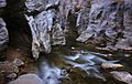
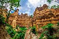
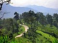
Chiang Mai province is a very popular place for tourists in northern Thailand. It is known for its beautiful mountains, valleys, and diverse plants and animals. The Hang Dong Canyon is a great example of its natural beauty. Unlike much of Thailand, Chiang Mai can be cool and misty during some months. This makes it a refreshing place to visit.
Health Services
Each district in Chiang Mai has its own hospital. Some of the largest hospitals are in Mueang Chiang Mai District. These include Maharaj Nakorn Chiang Mai Hospital and Nakornping Hospital.
Local Products and Crafts
Chiang Mai is famous for its handicrafts. You can find many unique items here, such as:
- Antiques
- Silver jewelry
- Embroidered goods
- Thai silks and cottons
- Baskets
- Celadon pottery
- Lacquerware
- Wood carvings
- Handmade parasols
Chiang Mai's Local Culture
The culture in northern Thailand is called Lanna culture. People here are very proud of their northern heritage. The region has its own special foods, music, art, and even a unique way of speaking. Chiang Mai is also home to various hill tribes, each with their own distinct cultures.
Delicious Local Food

Chiang Mai offers many tasty local dishes:
- Nam phrik ong is a chili paste made with minced pork and tomatoes. People usually eat it with boiled vegetables or pork crackling.
- Nam phrik num means "chili paste young man." It's another type of chili paste often eaten with pork crackling.
- Sai ua is a local sausage. It's very flavorful and spicy, often eaten with sticky rice.
- Kaeng means "curry." In the north, curries are often made without coconut milk.
- Kaeng hang-le is a northern-style pork curry.
- Kaeng om is a spicy curry that includes intestines.
- Kaeng khae is a spicy curry made mostly with vegetables.
- Khanom chin nam ngiao is a traditional northern noodle dish. It can be made with chicken or pork.
- Khao soi is a popular noodle dish. It can be made with chicken, pork, or beef in coconut milk. It's served with fresh shallots, pickled cabbage, chili paste, and a slice of lime.
Sports in Chiang Mai
Chiang Mai has two main sports stadiums. They are the 700th Anniversary Stadium and the Province Stadium. The 700th Anniversary Stadium is about 7 kilometers (4.3 miles) from Chiang Mai University. It has swimming pools, a diving pool, a basketball arena, and 11 tennis courts.
-
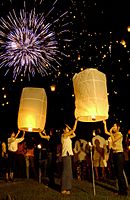
Chiang Mai, Yi Peng Festival
-
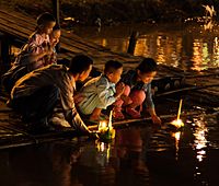
People floating krathong rafts during the Loi Krathong festival in Chiang Mai


Sister Cities Around the World
Chiang Mai province has special partnerships with eight other provinces or states around the world:
 Shanghai, China (since 2000)
 Yogyakarta, Indonesia (since 2007)
- Qingdao, China (since 2008)
- Chongqing, China (since 2008)
 Hokkaido, Japan (since 2013)
 Bursa, Turkey (since 2013)
 Chiang Tung, Myanmar (since 2014)
- Chengdu, China (since 2015)
Notable People from Chiang Mai

Some well-known people were born in Chiang Mai:
- Thaksin Shinawatra (born 1949), a politician and businessman.
- Yingluck Shinawatra (born 1967), also a politician.
Images for kids
-

The viewpoint at the 41st km of the Highway 1009, Doi Inthanon
-

Prunus cerasoides blooming at Doi Suthep–Pui National Park
-

Pong Dueat Hot Springs, Huai Nam Dang National Park
-
Ob Khan National Park
-
Mae Wang National park
-

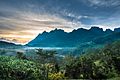
Doi Chiang Dao mountain
-

Pha Daeng National Park in Chiang Dao District
-
The mountains of Chiang Dao Wildlife Sanctuary in Chiang Dao District
-
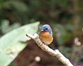
A photo of a hill blue flycatcher in the Chiang Dao Wildlife Sanctuary
-
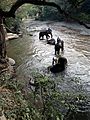
Bathing elephants in the Taeng River
-
Mae Thun Noi, Omkoi
-
The Fang River, part of the Mekong watershed, in Chai Prakan District
-
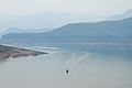
The lake of Mae Ngat Somboon Chon Dam, Si Lanna National Park
-
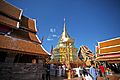
Wat Phra That Doi Suthep
-
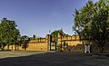
East gate (Tha Phae Gate) of the city wall
-

Shopping Mall in Chiang Mai
-
Thaton countryside
-
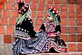
Hmong girls
-
The "flame of the forest"


See also
 In Spanish: Provincia de Chiang Mai para niños
