
Chitral District facts for kids
Quick facts for kids
Chitral
|
|
|---|---|

Map of Khyber Pakhtunkhwa with Chitral District highlighted
|
|
| Country | |
| Province | Khyber Pakhtunkhwa |
| Capital | Chitral |
| Established | 1970 |
| Area | |
| • Total | 14,850 km2 (5,730 sq mi) |
| Population
(2004)
|
|
| • Total | 378,000 |
| • Density | 25/km2 (60/sq mi) |
| Time zone | UTC+5 (PST) |
| Number of Tehsils | 6 |
| Website | http://www.nwfp.gov.pk/ |
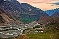
Chitral (Urdu: ضلع چترال) is a special district in the Khyber Pakhtunkhwa province of Pakistan. It is home to the town of Chitral. This area is very large, covering about 14,850 square kilometers.
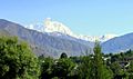
In 2004, about 378,000 people lived here. Chitral is famous for having one of the world's highest mountains, Tirich Mir. It is the biggest district in its province.
Contents
Where is Chitral Located?
Chitral District is the most northern part of the Khyber Pakhtunkhwa province. To its west and north is Afghanistan. A narrow strip of land called the Wakhan Corridor separates Pakistan from Central Asia.
To the east of Chitral are the Northern Areas of Pakistan. To the south are other Pakistani districts like Upper Dir and Swat. You can fly to Chitral using the Chitral Airport. It is only about 3 kilometers from the main town. Regular flights come from Peshawar and Islamabad.
What is the Land Like in Chitral?
The land in Chitral is very mountainous. It is part of the Pamir Mountains. Tirich Mir is the highest peak of the Hindu Kush mountain range. It stands tall at 7,708 meters (25,289 feet) in the north of the district.
Chitral connects to the rest of Pakistan by only two main roads. These are the Lowari Pass and Shandur Top. The Lowari Pass is 3,118 meters (10,230 feet) high. Shandur Top is 3,719 meters (12,200 feet) high. Both roads close during winter because of heavy snow.
A special tunnel, the Lowari Tunnel, is being built under the Lowari Pass. It helps people travel when the pass is closed. It opens a couple of times a week during winter.
There are also two other passes that you can cross on foot. These are the Broghol Pass and the Dorah Pass. Both come from Afghanistan and are also closed in winter.
Who Lives in Chitral?
Most people in Chitral are from the Kho people. They speak the Khowar language. This language is also spoken in parts of Yasin, Gilgit, and Swat.
Chitral is also home to the unique Kalash tribe. They live in three remote valleys southwest of Chitral town.
A linguist named Georg Morgenstierne once said that Chitral has the most different languages in the world. Even though Khowar is the main language, more than ten other languages are spoken here. These include:
- Kalasha-mun
- Erina
- Savi
- Palula
- Dameli
- Gawar-Bati
- Nuristani
- Yidgha
- Burushaski
- Wakhi
- Kyrgyz
- Persian
- Pashto
Many of these languages do not have a written form. So, people usually write letters in Urdu or Persian.
Chitral's Past
Until 1969, Chitral was like a small independent kingdom. It was called a princely state. In 1970, Chitral became a part of Pakistan. It was then known as the new Chitral District.
How is Chitral Managed?
The district of Chitral is divided into six smaller areas called tehsils. These are:
- Chitral
- Drosh Tehsil
- Lotkuh Tehsil
- Mastuj Tehsil
- Mulkoh Tehsil
- Turkoh Tehsil
People from Chitral also have representatives in the provincial assembly. These are elected members who speak for the people of Chitral.
Images for kids
-

Shandur, Chitral
-
Sunset reflections
-
Tirich Mir mountain near Chitral
-

Chitral Ayun valley
_20.jpg)


