
Chorleywood facts for kids
Quick facts for kids Chorleywood |
|
|---|---|

Chorleywood
|
|
| Population | 11,286 (2011 Census, Parish) |
| OS grid reference | TQ025965 |
| District |
|
| Shire county | |
| Region | |
| Country | England |
| Sovereign state | United Kingdom |
| Post town | Rickmansworth |
| Postcode district | WD3 |
| Dialling code | 01923 |
| Police | Hertfordshire |
| Fire | Hertfordshire |
| Ambulance | East of England |
| EU Parliament | East of England |
| UK Parliament |
|
Chorleywood is a village and civil parish in Hertfordshire, England. It is close to the border with Buckinghamshire. The village is about 20 miles (32 km) northwest of central London.
Chorleywood is next to the Chiltern Hills, a beautiful natural area. It is also part of the London commuter belt, which means many people who live here travel to London for work. In the past, Chorleywood was part of the larger area of Rickmansworth. It became its own separate parish in 1845. The population of Chorleywood was 11,286 in 2011.
A study in 2004 by the University of Oxford called Chorleywood the "happiest place" to live in the UK. It was ranked first out of 32,482 communities! More recently, it has been called the "least deprived" area in the country. This means it has very few problems like poverty or lack of services.
Contents
A Look Back: Chorleywood's History

People have lived in Chorleywood since the Paleolithic (Stone Age) period. There was a lot of flint here, which helped early humans make tools quickly. Later, the Romans built a village in this ancient spot. It even had a mill and a place to make beer!
Many Saxons settled here and called the area 'Cerola Leah'. This name means "a meadow in a clearing." A line that once separated the old kingdoms of Mercia and Wessex runs through Chorleywood. Today, this line divides the counties of Hertfordshire and Buckinghamshire. Edward the Confessor, an old English king, gave Chorleywood to the Monastery of St Albans.
By 1278, the area was known as 'Bosco de Cherle'. This was a Norman French name meaning "Peasant's Wood." Later, when monasteries were closed down, the land went to the Bishop of London. It was then called 'Charleywoode'. During the time of Elizabeth I, it became property of the Crown. In 1663, a law called the Turnpike Act allowed locals to charge people for using the road through Chorleywood. This was a way to make money from its important location.
Quakers and William Penn
Chorleywood is well-known for its connection to the Quakers. These were a group of Christians who did not follow the main church. Locals in Chorleywood offered them a safe place to live. William Penn, a famous Quaker, lived and married in Chorleywood. He later founded the Pennsylvania Colony in America. Many settlers from Chorleywood and nearby towns went with him.
Chorleywood House and the Railway
Chorleywood House is a beautiful old mansion built in 1822. It was built in the Regency style. Later, in 1892, Lady Ela Sackville Russell bought the house. She was the daughter of a Duke. She made the house bigger and turned the land into a model estate with market gardens.
By 1897, about 1,500 people lived in Chorleywood. Two years later, on July 8, 1889, the railway line was extended to the village. This helped Chorleywood grow even more.
The Famous Chorleywood Bread Process
In the early 1960s, scientists in Chorleywood made an important discovery. They worked at the British Baking Industries Research Association. They improved a way to make bread faster. This new method is called the Chorleywood Bread Process. Today, over 80% of the bread made in the UK uses this process!
In 1973, a TV show called Metro-land featured Chorleywood. The writer Sir John Betjeman called it "essential Metro-land". This term refers to the areas that grew along the Metropolitan Railway line.
Chorleywood Common: A Green Space

Chorleywood Common is a large area of wooded common land. It is about 0.8 square kilometers (200 acres) in size. The Common is a special place for nature, full of different plants, animals, fungi, and birds. It is a County Heritage Site and a Local Nature Reserve.
For a long time, cattle used to graze on the Common. But this stopped after the First World War. Since then, people have used the land for fun activities. The Chorleywood Golf Club has a nine-hole golf course on the Common. This golf club started in 1890 and is the oldest in Hertfordshire.
Christchurch, the local church, stands facing the Common. The first church was built in 1845. It was rebuilt in 1870, but its unique cedar wood tower was kept.
In the 1800s, the MCC created a cricket pitch on the Common. The Chorleywood Cricket Club still uses this pitch today for its teams.
How Chorleywood is Governed
Chorleywood has three levels of local government:
- Chorleywood Parish Council (for the village itself)
- Three Rivers District Council (for the wider district)
- Hertfordshire County Council (for the whole county)
Chorleywood was originally part of the larger Rickmansworth area. It became its own separate parish in 1898. Then, in 1913, Chorleywood became an "urban district." This meant it had more control over its own local matters. The Chorleywood Urban District Council bought Chorleywood House in 1939. This house then became the council's main office.
In 1974, the urban district was changed. Chorleywood joined with Rickmansworth and parts of Watford to form the new Three Rivers district. A new Chorleywood Parish Council was then created.
Getting Around: Transport

Chorleywood has grown a lot because of the Metropolitan Railway. Chorleywood station is on the London Underground Metropolitan line. Most trains here are run by London Underground. The station is also on the Chiltern Railways line, which connects to places like Marylebone in London.
The M25 (a major highway) has exits at Junctions 17 and 18 near Chorleywood. The A404 also runs through the area. There is also a bus route, the 336, that goes through Chorleywood.
Schools in Chorleywood
- St Clement Danes School is a secondary academy school.
- Christ Church School, Chorleywood Primary, and Russell School are primary schools.
People of Chorleywood
In 2011, the parish of Chorleywood had 11,286 residents. Here's a quick look at the population:
| Chorleywood (parish) |
Three Rivers | England & Wales | |
|---|---|---|---|
| Age | |||
| Median age | 44 | 41 | 39 |
| Under 18 | 23.8% | 22.7% | 21.3% |
| Over 65 | 20.5% | 16.8% | 16.4% |
| Ethnic group | |||
| White British | 79.6% | 79.7% | 80.5% |
| White Other | 6.0% | 6.6% | 5.5% |
| Indian or British Indian | 7.9% | 6.0% | 2.5% |
| Other Asian or British Asian | 3.1% | 3.2% | 5.0% |
| Black or Black British | 0.7% | 1.8% | 3.3% |
| Other ethnic group | 0.4% | 0.5% | 1.0% |
| Religion | |||
| Christian | 59.3% | 59.9% | 59.3% |
| Hindu | 5.8% | 4.5% | 1.5% |
| Jewish | 2.8% | 1.8% | 0.5% |
| Muslim | 2.1% | 2.2% | 4.8% |
| Another religion | 1.7% | 1.6% | 1.6% |
| No religion | 20.9% | 22.8% | 25.1% |
| Did not answer | 7.5% | 7.0% | 7.2% |
Sister City
Chorleywood is twinned with Dardilly, a town in France. This means they have a special friendship and exchange programs.
Famous People from Chorleywood
Many interesting people have lived in Chorleywood, including:
- Josephine Bradley (a dancer)
- Emily Corrie (an actress)
- Julie Felix (a folk singer)
- David Gauke (a politician)
- John Saunders Gilliat (who was in charge of the Bank of England)
- Madge Kendal (a famous actress)
- William Prowting Roberts (a lawyer)
- Johnny Speight (a TV writer)
- C. F. A. Voysey (a famous architect)
Freedom of the Parish
The "Freedom of the Parish" is a special honor given to people or groups who have done great things for Chorleywood.
Individuals
- Robert "Bob" Arthy: He received this honor on April 25, 2023.
Images for kids
-
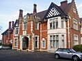
Chorleywood House, once the council's office.

See also
 In Spanish: Chorleywood para niños
