
Clark Fork River facts for kids
Quick facts for kids Clark Fork |
|
|---|---|

The Clark Fork at Missoula, Montana
|
|

Map of the Clark Fork, its main tributaries and downriver connection to the Columbia River via the Pend Oreille River.
|
|
| Other name(s) | Original name given by Lewis and Clark expedition: Clark's River |
| Country | United States |
| State | Montana, Idaho |
| Cities | Butte, Missoula |
| Physical characteristics | |
| Main source | Silver Bow Creek Butte, Silver Bow County, Montana 6,882 ft (2,098 m) 46°4′32″N 112°27′56″W / 46.07556°N 112.46556°W |
| 2nd source | Warm Springs Creek (Montana) Flint Creek Range, Granite County, Montana 7,466 ft (2,276 m) 46°15′39″N 113°8′12″W / 46.26083°N 113.13667°W |
| River mouth | Lake Pend Oreille Bonner County, Idaho 2,064 ft (629 m) 48°11′0″N 116°16′9″W / 48.18333°N 116.26917°W |
| Length | 310 mi (500 km) |
| Basin features | |
| Basin size | 22,905 sq mi (59,320 km2) |
| Tributaries |
|
The Clark Fork is a major river in the western United States. It flows through the states of Montana and Idaho. The river is about 310 mi (500 km) long. It is the largest river in Montana by the amount of water it carries.
The Clark Fork collects water from a huge area in the Rocky Mountains. This area covers parts of western Montana and northern Idaho. All this water eventually flows into the Columbia River. The river flows northwest through a long valley. This valley is at the base of the Cabinet Mountains. The Clark Fork then empties into Lake Pend Oreille in Idaho.
Sometimes, the Pend Oreille River is considered part of the Clark Fork. This river flows from Lake Pend Oreille into the Columbia River. If you include it, the total length of the system is about 479 mi (771 km). The highest point in the river's watershed is Mount Evans. It stands at 10,641 ft (3,243 m) high.
For the first 20 mi (32 km) of its journey in Montana, near Butte, the river is known as Silver Bow Creek. A major highway, Interstate 90, follows much of the upper part of the river. The Clark Fork is a popular spot for fun activities like boating in Montana.
Contents
Where Does the Clark Fork River Start and Flow?

The Clark Fork river begins as Silver Bow Creek in southwestern Montana. It starts less than 5 mi (8.0 km) from the Continental Divide of the Americas. This is near the city of Butte. Silver Bow Creek forms where two smaller creeks, Basin and Blacktail, meet.
The river then flows northwest and north through a mountain valley. It passes east of Anaconda. Here, it changes its name to the Clark Fork. This happens when it joins with Warm Springs Creek. Then it continues northwest to Deer Lodge. Near Deer Lodge, it receives water from the Little Blackfoot River.
From Deer Lodge, the river generally flows northwest across western Montana. It passes south of the Garnet Range on its way to Missoula. About 5 mi (8.0 km) east of Missoula, the river meets the Blackfoot River.
Northwest of Missoula, the river continues through a long valley. This valley is along the side of the Bitterroot Range. The river flows through the Lolo National Forest. It receives the Bitterroot River from the south-southwest. This is about 5.5 mi (8.9 km) west of downtown Missoula.
Near the Cabinet Mountains, the river receives the Flathead River from the east. This happens near Paradise. It also gets water from the Thompson River from the north. This is near Thompson Falls.
Dams Along the River
There are three main dams on the lower part of the Clark Fork River.
- The first is the Thompson Falls Dam. It's about 100 mi (160 km) northwest of Missoula. This dam was built in 1915. It's actually a series of four dams that connect between islands in the river.
- Next, near Noxon, Montana, is the Noxon Rapids Dam. It was finished in 1959. This dam creates a reservoir (a large artificial lake) that is about 20 mi (32 km) long.
- The river then crosses into Idaho. Just before the town of Cabinet, Idaho, is the Cabinet Gorge Dam. This dam was completed in the early 1950s. Its reservoir stretches back into Montana.
After passing the Cabinet Gorge Dam, the river flows into the northeast end of Lake Pend Oreille. This is about 8 mi (13 km) west of the Idaho–Montana border. The town of Clark Fork, Idaho is nearby.
A Look Back: History of the Clark Fork

Thousands of years ago, during the last ice age, the Clark Fork Valley was covered by a huge ice sheet. This ice sheet created a giant ice dam on the river. This dam formed a massive lake called Glacial Lake Missoula. This lake stretched across central Montana.
From time to time, the ice dam would break. This caused huge floods called the Missoula Floods. These floods rushed down the Clark Fork and Pend Oreille rivers. They carved out many of the land features we see today in eastern Washington and Oregon.
In the 1800s, the Flathead tribe of Native Americans lived in the Clark Fork Valley. The river was explored by Meriwether Lewis in 1806. He was part of the famous Lewis and Clark Expedition. The river is named after William Clark, who was also on that expedition. For a while, a part of the river in Montana was called the Missoula River.
In 1809, an explorer named David Thompson explored the area. He set up several fur trading posts. One was called Kullyspell House at the mouth of the Clark Fork. Another was Saleesh House near where Thompson Falls is today. Thompson called the whole river system the Saleesh River. For many years, British-Canadian fur trading companies controlled this region.
Later in the 1800s, cattle ranches replaced the wild bison in the valley. One famous ranch, the Grant-Kohrs Ranch, is now a National Historic Site. It helps tell the story of the river and the people who lived there.
The Clark Fork and the Blackfoot River had a record flood in 1908.
Protecting the River: Conservation Efforts
For a long time, mining activities in the river's watershed caused pollution. This was mainly from copper mines and a smelter. Many of these polluted areas are now part of a special cleanup program. Even with these challenges, the river and its smaller streams are very popular for fly fishing.
Today, the Clark Fork watershed is part of a very large environmental cleanup effort in America. This effort includes three main areas: Butte, Anaconda, and the Milltown Dam/Clark Fork River area. Each of these areas has many smaller cleanup projects.
The Milltown Dam was removed in 2008. It was located where the Clark Fork and Blackfoot Rivers meet. Another old dam, Stimson Dam, was removed in 2007. The area that used to be under Milltown Lake is now a State Park. Work to clean up and restore these areas is still happening.
Many groups are working together to protect the Clark Fork-Pend Oreille river system. These include citizens, businesses, tribes, government, and environmental groups. They work to protect and restore the river basin.
One group, WEN (Watershed Education Network), is based in Missoula, Montana. WEN teaches people about the health of watersheds. Since 1996, WEN has been helping to train the next generation of river protectors. They have a School Stream Monitoring Program. Through this program, students learn about the river's health. They go on field trips to different stream sites. They learn how human activities affect the river. This helps them understand how to keep the watershed healthy.
See also
 In Spanish: Río Clark Fork para niños
Images for kids
-
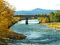
The Clark Fork at Missoula, Montana
-
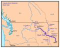
Map of the Clark Fork, its main tributaries and downriver connection to the Columbia River via the Pend Oreille River.
-
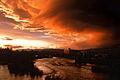
The Clark Fork river flows through downtown Missoula (2003).
-
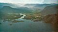
The mouth of the Clark Fork on Lake Pend Oreille in Idaho.
