
Clatsop Plains facts for kids
Quick facts for kids Clatsop Plains |
|
|---|---|

Aerial view of the northern Clatsop Plains
|
|

Location in Oregon
|
|
| Location | Clatsop County, Oregon |
| Coordinates | 46°04′04″N 123°55′51″W / 46.067884°N 123.930696°W |
| Age | Quaternary |
The Clatsop Plains are a special area in northwestern Oregon, United States. They are a mix of wetlands (swampy areas) and sand dunes. These plains stretch along the Pacific Ocean coast. They go from the mouth of the Columbia River down to Tillamook Head near Seaside.
Several rivers flow through the plains. These include the Skipanon River and the Necanicum River. The Skipanon flows into the Columbia River at Youngs Bay near Astoria. The Necanicum flows into the Pacific Ocean near Seaside.
|
The Clatsop Plains
|
When the Lewis and Clark expedition explored this area, they noted a different river. This river drained the plains and entered the Pacific near today's Camp Rilea. In 2005, research confirmed this. They found an old river channel that matched the expedition's records.
Contents
Who are the Clatsop People?
The plains are named after the Clatsop tribe. They are a group of Native Americans. The Clatsop people lived in this area for a long time. They were here when Europeans and European Americans first arrived. Some came by ship in the late 1700s. Others came by land in the early 1800s.
How the Plains Formed
The Clatsop Plains were formed by sand. This sand filled in the shoreline during the late Quaternary age. This is a very long time ago in Earth's history. The northern part of the plains grew bigger after 1885. This was when a south jetty (a long wall) was built on the Columbia River.
Lakes of the Plains
There are several lakes within the Clatsop Plains. These include Cullaby, Sunset (also called Neacoxie), Smith, and Coffenbury. The last three lakes are special. They are filled by groundwater (water from underground). They do not get their water from local streams or rivers.
Early Settlements and Churches
The first white settlers on the Clatsop Plains were two Methodist missionaries. They were the first missionaries to come to Clatsop County. Solomon H. Smith and Rev. Joseph H. Frost started a Methodist mission here in 1841. They built homes for their families on the plains.
First Protestant Church
The first Presbyterian church in the area was founded in 1846. A man named Robert Morrison gave 10 acres of land for the church. He also gave two more acres for a cemetery. The first church building was finished in 1850. But a strong windstorm destroyed it in 1853.
This church was very important. It was the first Protestant church built west of the Rocky Mountains. A new church was built after the storm. It served the community until 1927. That's when the current church building replaced it. The church is located east of Camp Rilea. The Pioneer cemetery, started in 1846, is the oldest in the county. Many early settlers are buried there.
The Community of Clatsop Plains
A community called "Clatsop Plains" was officially formed in 1870. Its main goal was to stop cattle from grazing too much. The cattle were eating the grass and plants along the sea ridge. This was a problem because these plants helped hold the sand in place. Without them, sand would blow onto nearby farms.
Originally, "Clatsop Plains" stretched from the Skipanon River to Seaside. A small town eventually grew about a mile north of Seaside. This town was later absorbed into Gearhart. Because it was so close to Seaside, Seaside itself was sometimes called Clatsop Plains.
Wildlife of the Plains
The grassy areas along the coast of Clatsop Plains are home to a special butterfly. It's called the Oregon silverspot butterfly (Speyeria zerene hippolyta). This butterfly is an endangered species. This means it's at risk of disappearing forever.
Travel on the Plains
A part of U.S. Route 101, also known as the Oregon Coast Highway, runs through most of the Clatsop Plains. This highway makes it easy to travel along this unique coastal area.
Gallery
-
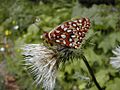
Oregon silverspot butterfly
-
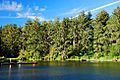
Coffenbury Lake (named for an early settler, George W. Coffenberry/Coffinberry)

_(clatDA0097a).jpg)
