Claymont, Delaware facts for kids
Quick facts for kids
Claymont, Delaware
|
|
|---|---|
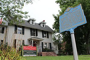
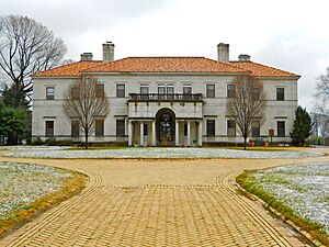
The Darley House
|
|
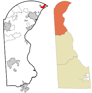
Location of Claymont in New Castle County, Delaware (left) and of New Castle County in Delaware (right)
|
|
| Country | United States |
| State | Delaware |
| County | New Castle |
| First settled | Before 1200 |
| Renamed | 1856 |
| Government | |
| • Type | Claymont Renaissance (de facto) |
| Area | |
| • Total | 2.15 sq mi (5.57 km2) |
| • Land | 2.15 sq mi (5.57 km2) |
| • Water | 0.00 sq mi (0.00 km2) |
| Elevation | 75 ft (23 m) |
| Population
(2020)
|
|
| • Total | 9,895 |
| • Density | 4,600.19/sq mi (1,776.54/km2) |
| Time zone | UTC-5 (Eastern (EST)) |
| • Summer (DST) | UTC-4 (EDT) |
| ZIP Code |
19703
|
| Area code(s) | 302 |
| FIPS code | 10-15310 |
| GNIS feature ID | 213804 |
Claymont is a community in New Castle County, Delaware, United States. It is known as a census-designated place (CDP). This means it's a specific area defined for gathering census information, but it's not an officially incorporated city or town. In 2020, about 9,895 people lived in Claymont.
Contents
A Look at Claymont's Past
The Claymont area began along the Naamans Creek, where it flows into the Delaware River. People have lived here for a very long time, even before 1200 A.D. The community has changed a lot over the centuries. You can still see these changes in the buildings and how people live today.
Who Lived Here First?
The first people to live here were Native Americans from the Middle Woodland period (1100-1600 B.C.). Their traces have been found along Naamans Creek. The Dutch explorers later named the creek and settlement after the Chief of the Lenape tribe. The area grew quickly from the 1600s to the 1900s. It started with farms and mills, then added lumber mills, a steel mill, and a chemical plant.
Early Settlements and Travel
In 1681, a man named John Grubb bought a large piece of land. This land became known as Grubb's Landing. Claymont was a key stop for travelers between Philadelphia and Washington, D.C.. It was part of the old King's Highway. Today, major highways like I-95 and US 13 still pass through Claymont.
How Claymont Grew
In 1838, the new Philadelphia, Wilmington and Baltimore Railroad built a station in Claymont. This helped the area change from mostly farms to a popular vacation spot for rich families from Philadelphia. Later, in the early 1900s, it became an industrial area with many workers.
The name "Naamans" changed to "Claymont" in 1856. This happened after Reverend John B. Clemson moved his family here. They came from their home called Claymont Court in Charles Town, West Virginia. Claymont has always had a mix of people. Its churches, community groups, and historical societies help keep its unique spirit alive.
Bringing Claymont Back to Life
Since the mid-1990s, many efforts have been made to improve Claymont. Historic places like the Claymont Stone School and the Darley House have been restored. The Claymont Renaissance Development Corporation is a group that works to help the community grow. They have won awards for their work.
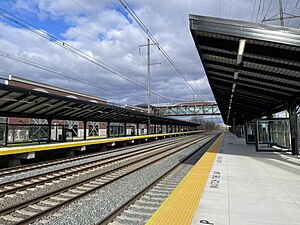
A big project called Darley Green replaced an older neighborhood. Also, plans were announced in 2017 to redevelop the large former Claymont Steel site. In 2019, construction began on a new $71 million train station. This new station will replace the smaller one currently used by commuters.
Where is Claymont Located?
Claymont is located at 39°48′02″N 75°27′35″W / 39.80056°N 75.45972°W. It sits in the northeastern part of Brandywine Hundred. The area is on a ridge between the flat coastal land of the Delaware River and the higher upland region.
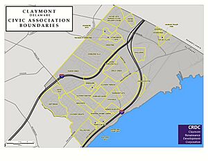
The area generally known as Claymont covers the entire 19703 ZIP code. It is bordered by Pennsylvania to the north and the Delaware River to the east. A railroad line is to the west, and Perkins Run creek is to the south.
Who Lives in Claymont?
| Historical population | |||
|---|---|---|---|
| Census | Pop. | %± | |
| 2020 | 9,895 | — | |
| U.S. Decennial Census | |||
The 19703 ZIP code area includes several neighborhoods. These include Ashbourne Hills, Greentree, Society Hill, and parts of Rolling Park. In 2010, about 14,471 people lived in this larger area. There were nearly 6,000 households. The average household had about 2.42 people. The median household income in 2010 was $58,304.
Learning in Claymont
Claymont is part of the Brandywine School District. There is also a private school in Claymont called Archmere Academy.
Getting Around Claymont
Many important roads pass through Claymont. These include Interstate 95, Interstate 495, US 13, and DE 92.
The Claymont Station is a train stop for SEPTA Regional Rail. You can take a train north to Philadelphia or south to Wilmington and Newark. Amtrak trains also pass through Claymont, but they do not stop here. The closest Amtrak station is in Wilmington.
Buses are also available through DART First State. Route 13 goes from Claymont Station south to Wilmington. Route 61 goes west from the station along Naamans Road. SEPTA Suburban Bus Route 113 goes north into Pennsylvania. It connects to places like Chester and Upper Darby.
Cool Places to See in Claymont
Claymont has several interesting historical sites:
- The Claymont Stone School, built in 1805, might have been Delaware's first public school open to all races.
- Archmere Academy, founded in 1916, is in the former home of a famous businessman, John J. Raskob.
- The Darley House, built in 1859, was the home of illustrator F. O. C. Darley.
- The Grubb/Worth Mansion was built in 1783.
- The Robinson House has a Block House. This is believed to be the only building left from the original Naaman's Creek settlement.
Famous People From Claymont
Many notable people have connections to Claymont:
- Valerie Bertinelli, an actress known for One Day at a Time.
- Joe Biden, the 46th President of the United States. He also served as a U.S. Senator and Vice President.
- John Carney, the current Governor of Delaware.
- J. Caleb Boggs, a former Governor of Delaware and U.S. Senator.
- F. O. C. Darley, known as the "Father of American Illustration."
- John Grubb, one of the first settlers of Claymont.
- Nathaniel Grubb, who served in the Pennsylvania Colonial Assembly.
- Keith "Bang Bang" McCurdy, a famous tattoo artist.
- John J. Raskob, a top executive at DuPont and General Motors.
- Adolf Ulric Wertmüller, a Swedish portrait painter.
See also
 In Spanish: Claymont para niños
 | Lonnie Johnson |
 | Granville Woods |
 | Lewis Howard Latimer |
 | James West |


