Coldwater Lake (Washington) facts for kids
Quick facts for kids Coldwater Lake |
|
|---|---|

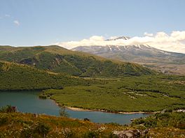
Coldwater Lake is seen here from the Coldwater Ridge Visitor Center. Mount St. Helens is in the background.
|
|
| Location | Washington, U.S. |
| Coordinates | 46°18′14″N 122°14′13″W / 46.304°N 122.237°W |
| Type | Landslide-dammed lake |
| Primary inflows | Coldwater Creek South Coldwater Creek |
| Primary outflows | Coldwater Creek |
| Catchment area | 16.55 sq mi (42.9 km2) |
| Basin countries | United States |
| First flooded | May 18, 1980 |
| Max. length | 5 mi (8 km) |
| Max. width | 0.5 mi (0.8 km) |
| Surface area | 773.2 acres (312.9 ha) |
| Average depth | 87 ft (27 m) |
| Max. depth | 180 ft (55 m) |
| Water volume | 67,300 acre⋅ft (83,000,000 m3) |
| Surface elevation | 2,503 ft (763 m) |
| Islands | Kim Island is the only permanent island, sutuated toward the west end of the lake. There are a few very shallow areas that break the surface depending on water levels. |
Coldwater Lake is a special lake in Washington, U.S.. It sits on the edge of Cowlitz and Skamania counties. This lake was formed in a very exciting way! It appeared during the huge 1980 eruption of Mount St. Helens. The eruption caused a lot of volcanic rock and dirt to slide, blocking a stream called Coldwater Creek. This blockage created the lake. Coldwater Lake is one of several lakes in the area that grew bigger or were made new because of the eruption.
Contents
Where Is Coldwater Lake Located?
Coldwater Lake stretches from the northeast to the southwest. The western part is in Cowlitz County. The eastern part is in Skamania County. This eastern section is also part of the Gifford Pinchot National Forest.
How Water Flows Through the Lake
Coldwater Creek flows out of the lake's southwest end. It then joins the North Fork of the Toutle River. The Toutle River is a branch of the Cowlitz River, which eventually flows into the big Columbia River.
Nearby Natural Landmarks
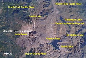
Coldwater Lake is about 8 miles (13 km) north of Mount St. Helens. It is also 5 miles (8 km) west of Spirit Lake. Another lake, Castle Lake, formed in the same way. It is about 3 miles (4.8 km) south of Coldwater Lake. The area is about 50 miles (80 km) northeast of Longview. It is also 100 miles (160 km) north of Portland, Oregon.
What Does the Lake Look Like?
Coldwater is a long, narrow lake. It sits in a valley that was carved by a glacier. The hills around the lake rise steeply, more than 1,000 feet (300 m) above the water. The lake is about 5 miles (8.0 km) long. Its widest point is less than half a mile (0.8 km) across. The water surface is 2,503 feet (763 m) above sea level. The lake covers an area of 773 acres (313 ha).
Water Sources for Coldwater Lake
The total area that drains water into Coldwater Lake is about 16.6 sq mi (43 km2). Coldwater Creek brings water from 5.4 square miles (14 km2) of this area. South Fork Coldwater Creek adds water from 6.3 square miles (16 km2). The rest of the water, about 4.9 square miles (13 km2), flows directly into the lake. Some smaller lakes also feed into Coldwater Lake. These include Heart Lake and Snow Lake. They both flow into Coldwater Creek first. Mount Whittier is the highest point in this area. It is 5,883-foot (1,793 m) tall.
How Coldwater Lake Was Formed
The eruption of Mount St. Helens on May 18, 1980, was huge. It caused a giant flow of mud and debris. This flow, called a lahar, rushed down the North Fork of the Toutle River. It buried the whole valley, in some places up to 600 feet (180 m) deep.
The Lake's Creation and Growth
The lahar blocked Coldwater Creek for over a mile (1.6 km). It created a natural dam, about 180 feet (55 m) high. Over the next few months, a lot of water collected. Almost 100,000 acre-feet (120,000,000 m3) of water filled up. This formed a new lake, about 5 miles (8 km) long. Experts thought the lake would soon overflow its natural dam. This could cause serious floods downstream. The dam was made of soft volcanic ash and debris. It would erode quickly if too much water flowed over it.
Making the Lake Safe
To prevent flooding, the U.S. Army Corps of Engineers took action. In early 1981, they dug a special channel. This channel, called a spillway, helped control the lake's water level. It stabilized the lake at 2,503 feet (763 m) above sea level. The lake's volume became 67,300 acre-feet (83,000,000 m3).
Connecting to Spirit Lake
In May 1985, a tunnel was dug. This tunnel connected Spirit Lake to South Coldwater Creek. The eruption had also blocked Spirit Lake's outlet. This caused its water level to rise dangerously high. The new tunnel allowed extra water from Spirit Lake to flow into Coldwater Lake. From there, it drained safely into the Toutle River. The natural dam at Coldwater Lake was watched closely until 1998. By then, it was considered stable and safe.
Changes Around the Lake
Since its formation, the lake has slowly gotten a bit smaller. This is due to natural erosion. The area around the lake, about 17-square-mile (44 km2), lost most of its plants during the 1980 eruption. However, the land has recovered a lot over the years. New forests are growing back. Several deltas have formed around the lake. The biggest one is at South Coldwater Creek. This valley was closest to the volcanic blast.
Fun Things to Do at Coldwater Lake
Coldwater Lake is now part of the Mount St. Helens National Volcanic Monument. This special area was created in 1982. You can get there by taking Washington State Route 504 (the Spirit Lake Highway) from Interstate 5 at Castle Rock.
Visitor Centers and Trails
The Coldwater Ridge Visitor Center is on the cliffs west of the lake. It offers amazing views of the valley. On weekends, a Science and Learning Center is open there for visitors. The Coldwater Lake Recreation Area is at the south end of the lake. It's for day use only. This area is inside the protected zone of the National Monument.
Activities at the Recreation Area
The recreation area has a picnic spot and restrooms. There's also a boat ramp for non-motorized boats. This means you can use canoes, kayaks, or rowboats, but no motorboats. The 0.6-mile (1 km) Birth of a Lake Trail is a boardwalk path. You can access it from the recreation area. It has signs that explain how the lake was formed by the eruption. The Lakes Trail runs along the western shore. It lets you explore the Mount Margaret Backcountry beyond the lake.
Fishing at Coldwater Lake
Coldwater Lake has been home to rainbow trout and cutthroat trout for a long time. The Washington State Department of Fish and Wildlife (DFW) first put these fish in the lake in the 1980s. Before the 1980 eruption, all the fish in Coldwater Creek and the Toutle River were wiped out. The DFW no longer adds fish to the lake. However, they still manage it as a great place to catch trout. If you go fishing, you can catch one fish per day. It must be at least 16 inches (41 cm) long.
 | Delilah Pierce |
 | Gordon Parks |
 | Augusta Savage |
 | Charles Ethan Porter |


