
Del Norte, Colorado facts for kids
Quick facts for kids
Del Norte, Colorado
|
|
|---|---|

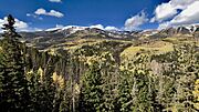
Del Norte from the summit of Lookout Mountain with the Sangre de Cristo Range in the background.
|
|

Location of the Town of Del Norte in the Rio Grande County, Colorado.
|
|

Del Norte, Colorado
Location in the United States
|
|
| Country | |
| State | |
| Incorporated | 1895-11-15 |
| Government | |
| • Type | Statutory Town |
| Area | |
| • Total | 0.983 sq mi (2.547 km2) |
| • Land | 0.983 sq mi (2.547 km2) |
| • Water | 0 sq mi (0.000 km2) |
| Elevation
(official)
|
7,884 ft (2,403 m) |
| Highest elevation
(At summit of Lookout Mountain)
|
8,475 ft (2,583 m) |
| Lowest elevation
(Rio Grande at east-end of town)
|
7,874 ft (2,400 m) |
| Population
(2020)
|
|
| • Total | 1,458 |
| Time zone | UTC−07:00 (MST) |
| • Summer (DST) | UTC−06:00 (MDT) |
| ZIP code |
81132
|
| Area code(s) | 719 |
| FIPS code | 08-19795 |
| GNIS feature ID | 2412416 |
Del Norte is a town in Colorado, United States. It is the main town, or county seat, of Rio Grande County. The town's name comes from the Rio Grande river, which was once called "Rio Grande del Norte," meaning "large river of the north." In 2020, about 1,458 people lived in Del Norte.
Contents
History of Del Norte
Early Peoples and Explorers
Thousands of years ago, ancient people like the Folsom people lived around Del Norte. We know this because their arrowheads and old campsites have been found. Later, the Utes lived in the San Luis Valley, where Del Norte is located. They stayed here during warmer months because there was plenty of food, water, and timber. Winters were too cold for them to live here permanently.
Spanish and Mexican explorers were the first non-native people to visit this area. They came from places like Santa Fe to explore the "River of the North," which is why Del Norte got its name.
Settlement and Growth
In the early to mid-1800s, under Mexican rule, Hispanic families started to move into the area. They were part of land grants meant to help Mexico settle the territory. However, it was hard to build large towns because the Utes did not want new settlers and would often chase them away.
One of the first successful settlements nearby was called 'La Loma'. It was a few miles east of where Del Norte is today. This spot was chosen because it had a safe and easy place to cross the Rio Grande river.
After the Treaty of Guadalupe Hidalgo in 1848, the land around Del Norte became part of the United States. But American settlement was delayed by big events like the American Civil War. Most American settlers started arriving in the early 1870s. These were often prospectors looking for gold and silver in the nearby mountains, especially near a town called Summitville.
Mining Boom and Beyond
Miners were finally allowed to explore these mountains after the Brunot Treaty was signed with the Utes in 1873. Once the mines started making money, Del Norte was officially founded around 1874. It became a base camp for miners working in Summitville and other towns like Creede and Lake City.
Miners quickly moved in, followed by ranchers and farmers. Many of these farming and ranching families still live and work in the Del Norte area today. When mining became less profitable after 1893, Del Norte's "glory days" of mining ended. However, the town survived because of its strong ranching and farming communities.
In the late 1800s and early 1900s, there was a small idea to create a new state called San Juan, with Del Norte as its capital. But this idea did not last long.
Del Norte Today
Del Norte has had its ups and downs over the years. But recently, it has become a lively community. This is because the area offers many fun outdoor activities like mountain biking, hiking, rock climbing, fishing, hunting, rafting, kayaking, and camping. Del Norte also provides places to stay for visitors to the nearby Wolf Creek Ski Area.
The main street, Grande Avenue, still has many old buildings from the 1800s and early 1900s. These remind everyone of the town's rich history. In 2019, the Rio Grande National Forest announced it would move its main office to Del Norte. The town also plans to improve its riverwalk and add a white-water park along the Rio Grande.
Geography and Climate
Where is Del Norte?

Del Norte is located where the Rio Grande river leaves the San Juan Mountains and flows into the San Luis Valley. It is near where Pinos Creek and San Francisco Creek join the Rio Grande. Because of its location at the edge of the valley, you can find many different types of environments nearby. Within 20 miles of town, you can see everything from high mountain areas (alpine tundra) to forests and even high-altitude deserts.
Common plants around Del Norte include pine trees, aspen trees, cottonwoods, sagebrush, and cacti. In the warmer months, you can often see beautiful flowers like hollyhock, cosmos, poppies, and sunflowers.
Lookout Mountain, also known as 'D' Mountain, is a famous landmark that overlooks the town. Even though it's called a "mountain," it's not as tall as some other nearby peaks. But it's still a very noticeable feature of the area.
At the 2020 United States Census, the town covered about 2.547 square kilometers (about 0.98 square miles) of land.

Del Norte's Weather
Del Norte has a semi-arid or high-altitude desert climate. This means it doesn't get a lot of rain or snow. The amount of rain can change a lot each year, from 10-12 inches in a wet year to 6 inches or less in a dry year.
One reason for this is that Del Norte is in a rain shadow created by the San Juan Mountains. This means the mountains block much of the rain and snow. For example, the Wolf Creek Ski Area, about 28 miles west, gets over 400 inches of snow each year. Del Norte only gets about 40 inches.
Most of the precipitation comes as rain or snow. Hail and sleet are rare. Generally, summers in Del Norte are mild, and winters are cold. Spring and autumn can vary. Spring often brings strong winds, and some of the biggest snowstorms happen then. Summer monsoons can occur from July to September. During these, mornings are sunny, but clouds and storms often move in during the afternoon, bringing light rain or heavy downpours. Like most of Colorado, nighttime temperatures can drop quickly because the air is dry.
| Climate data for Del Norte, Colorado, 1991–2020 normals, extremes 1893–present | |||||||||||||
|---|---|---|---|---|---|---|---|---|---|---|---|---|---|
| Month | Jan | Feb | Mar | Apr | May | Jun | Jul | Aug | Sep | Oct | Nov | Dec | Year |
| Record high °F (°C) | 61 (16) |
68 (20) |
73 (23) |
80 (27) |
87 (31) |
92 (33) |
93 (34) |
89 (32) |
87 (31) |
81 (27) |
70 (21) |
62 (17) |
93 (34) |
| Mean maximum °F (°C) | 46.5 (8.1) |
51.2 (10.7) |
64.5 (18.1) |
71.0 (21.7) |
77.4 (25.2) |
84.7 (29.3) |
85.3 (29.6) |
83.2 (28.4) |
80.2 (26.8) |
73.6 (23.1) |
60.3 (15.7) |
50.0 (10.0) |
86.5 (30.3) |
| Mean daily maximum °F (°C) | 34.6 (1.4) |
40.2 (4.6) |
51.5 (10.8) |
59.4 (15.2) |
68.1 (20.1) |
77.6 (25.3) |
80.5 (26.9) |
78.5 (25.8) |
73.0 (22.8) |
62.7 (17.1) |
48.6 (9.2) |
36.4 (2.4) |
59.3 (15.1) |
| Daily mean °F (°C) | 20.9 (−6.2) |
26.6 (−3.0) |
36.1 (2.3) |
43.3 (6.3) |
52.1 (11.2) |
60.6 (15.9) |
65.0 (18.3) |
63.5 (17.5) |
56.6 (13.7) |
46.2 (7.9) |
33.1 (0.6) |
22.6 (−5.2) |
43.9 (6.6) |
| Mean daily minimum °F (°C) | 7.2 (−13.8) |
12.9 (−10.6) |
20.6 (−6.3) |
27.3 (−2.6) |
36.1 (2.3) |
43.6 (6.4) |
49.6 (9.8) |
48.5 (9.2) |
40.2 (4.6) |
29.7 (−1.3) |
17.6 (−8.0) |
8.9 (−12.8) |
28.5 (−1.9) |
| Mean minimum °F (°C) | −8.0 (−22.2) |
−3.6 (−19.8) |
4.9 (−15.1) |
13.5 (−10.3) |
23.2 (−4.9) |
32.9 (0.5) |
41.5 (5.3) |
40.2 (4.6) |
27.9 (−2.3) |
14.1 (−9.9) |
0.9 (−17.3) |
−8.0 (−22.2) |
−11.9 (−24.4) |
| Record low °F (°C) | −34 (−37) |
−24 (−31) |
−16 (−27) |
−4 (−20) |
10 (−12) |
22 (−6) |
32 (0) |
30 (−1) |
15 (−9) |
2 (−17) |
−20 (−29) |
−26 (−32) |
−34 (−37) |
| Average precipitation inches (mm) | 0.36 (9.1) |
0.39 (9.9) |
0.72 (18) |
0.79 (20) |
0.80 (20) |
0.60 (15) |
1.50 (38) |
1.66 (42) |
1.06 (27) |
0.81 (21) |
0.48 (12) |
0.51 (13) |
9.68 (245) |
| Average snowfall inches (cm) | 5.3 (13) |
5.7 (14) |
8.2 (21) |
5.0 (13) |
1.3 (3.3) |
0.0 (0.0) |
0.0 (0.0) |
0.0 (0.0) |
0.0 (0.0) |
2.5 (6.4) |
4.8 (12) |
5.8 (15) |
38.6 (97.7) |
| Average extreme snow depth inches (cm) | 5.7 (14) |
5.6 (14) |
4.3 (11) |
2.9 (7.4) |
1.2 (3.0) |
0.0 (0.0) |
0.0 (0.0) |
0.0 (0.0) |
0.0 (0.0) |
1.7 (4.3) |
3.4 (8.6) |
4.8 (12) |
9.4 (24) |
| Average precipitation days (≥ 0.01 in) | 3.4 | 4.1 | 5.1 | 4.8 | 5.7 | 5.1 | 10.8 | 12.7 | 7.6 | 5.0 | 3.7 | 3.9 | 71.9 |
| Average snowy days (≥ 0.1 in) | 3.6 | 4.0 | 4.0 | 2.4 | 0.6 | 0.0 | 0.0 | 0.0 | 0.0 | 1.0 | 2.8 | 4.2 | 22.6 |
| Source 1: NOAA | |||||||||||||
| Source 2: National Weather Service | |||||||||||||
Population of Del Norte
| Historical population | |||
|---|---|---|---|
| Census | Pop. | %± | |
| 1880 | 729 | — | |
| 1890 | 736 | 1.0% | |
| 1900 | 705 | −4.2% | |
| 1910 | 840 | 19.1% | |
| 1920 | 1,007 | 19.9% | |
| 1930 | 1,410 | 40.0% | |
| 1940 | 1,923 | 36.4% | |
| 1950 | 2,048 | 6.5% | |
| 1960 | 1,856 | −9.4% | |
| 1970 | 1,569 | −15.5% | |
| 1980 | 1,709 | 8.9% | |
| 1990 | 1,674 | −2.0% | |
| 2000 | 1,705 | 1.9% | |
| 2010 | 1,686 | −1.1% | |
| 2020 | 1,458 | −13.5% | |
| U.S. Decennial Census | |||
According to the census in 2000, there were 1,705 people living in Del Norte. These people lived in 657 households, with 446 of them being families. The town had about 2,004 people per square mile.
The population included people of different backgrounds. About 67% were White, and about 57% were of Hispanic or Latino heritage.
In 2000, about 30% of the people in Del Norte were under 18 years old. About 13% were 65 years or older. The average age in the town was 35 years.
Famous People from Del Norte
- Alva B. Adams - He was a US senator who represented Colorado.
- Kent Rominger - He is an astronaut who went to Del Norte High School.
Gallery
-
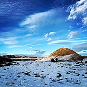
Sunset on 'D' Mountain near Del Norte, Colorado.
-
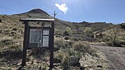
Columbia trailhead on the Lookout Mountain trail system.
-
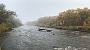
The river walk along the Rio Grande in Del Norte, Colorado.
-
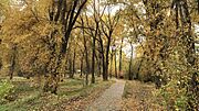
Cottonwood trees in fall colors along the river walk.
-
The South San Juan Mountains during the Autumn, just a few miles from town.
-
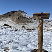
A trail marker along the School Loop of the Lookout Mountain trail system.
-

Del Norte Town Hall


See also
 In Spanish: Del Norte (Colorado) para niños
