
Des Moines County, Iowa facts for kids
Quick facts for kids
Des Moines County
|
|
|---|---|

Des Moines County Courthouse
|
|

Location within the U.S. state of Iowa
|
|
 Iowa's location within the U.S. |
|
| Country | |
| State | |
| Founded | 1834 |
| Named for | Des Moines River |
| Seat | Burlington |
| Largest city | Burlington |
| Area | |
| • Total | 430 sq mi (1,100 km2) |
| • Land | 416 sq mi (1,080 km2) |
| • Water | 14 sq mi (40 km2) 3.2% |
| Population
(2020)
|
|
| • Total | 38,910 |
| • Estimate
(2023)
|
38,253 |
| • Density | 90.5/sq mi (34.9/km2) |
| Time zone | UTC−6 (Central) |
| • Summer (DST) | UTC−5 (CDT) |
| Area code | 319 |
| Congressional district | 1st |
Des Moines County is a county in the state of Iowa, USA. It is located in the southeastern part of Iowa. The county is home to about 38,910 people, based on the 2020 census.
The main city and county seat is Burlington. This means Burlington is where the county government offices are. Des Moines County was one of the first two counties created in Iowa in 1834.
It's important not to confuse Des Moines County with the city of Des Moines. The city of Des Moines is the capital of Iowa. It is located in Polk County, which is in central Iowa. Des Moines County is on Iowa's eastern border, right next to the Mississippi River. Both the county and the city got their names from the Des Moines River.
Contents
History of Des Moines County
Des Moines County has a long and interesting history. In September 1834, the area that is now Iowa was part of the Michigan Territory. Lawmakers decided to divide this land into two counties. One was called Dubuque County, and the other was called Demoine County. This county was named after the Des Moines River.
From 1836 to 1838, Des Moines County was part of the Wisconsin Territory. After that, on July 4, 1838, it became part of the new Iowa Territory. Later, Iowa became a state.
The building used today as the Des Moines County Court House was finished in 1940. Also in 1940, the Iowa Army Ammunition Plant was built. This plant helps make things for the U.S. Army.
Geography of Des Moines County

Des Moines County covers about 430 square miles. Most of this area is land, about 416 square miles. The rest, about 14 square miles, is water.
The mighty Mississippi River forms the eastern border of the county. The Skunk River forms the southern border. Smaller streams like Flint Creek also flow through the county.
Main Roads
 U.S. Highway 34
 U.S. Highway 61
Public Transportation
- Burlington station: This is a train station.
- Burlington Urban Service: This is a local bus service.
Airport
The Southeast Iowa Regional Airport (airport code BRL) is located near Burlington. It helps people travel by air.
Neighboring Counties
Des Moines County shares its borders with several other counties:
- Louisa County (to the north)
- Hancock County, Illinois (to the southeast)
- Henderson County, Illinois (to the east)
- Lee County (to the south)
- Henry County (to the west)
People of Des Moines County (Demographics)

Demographics is the study of people in a certain area. It looks at things like how many people live there and what their backgrounds are.
2020 Census Information
In 2020, the census counted 38,910 people living in Des Moines County. This means there were about 92 people per square mile. Most people (about 94%) said they belonged to one race.
Here's a quick look at the different groups of people in Des Moines County in 2020:
| Race | Number of People | Percentage |
|---|---|---|
| White (not Hispanic) | 32,753 | 84.2% |
| Black or African American (not Hispanic) | 2,501 | 6.43% |
| Native American (not Hispanic) | 67 | 0.2% |
| Asian (not Hispanic) | 398 | 1.02% |
| Pacific Islander (not Hispanic) | 21 | 0.05% |
| Other/Mixed (not Hispanic) | 1,925 | 5% |
| Hispanic or Latino | 1,245 | 3.2% |
Communities in Des Moines County
Des Moines County has several cities and smaller communities.
Cities
Census-Designated Places (CDPs)
These are areas that look like towns but are not officially cities.
- Augusta
- Beaverdale
- Kingston
- Oak Hills
- Sperry
- Yarmouth
Other Small Communities
Townships
Counties in Iowa are divided into smaller areas called townships. Here are the townships in Des Moines County:
- Benton
- Concordia
- Danville
- Flint River
- Franklin
- Huron
- Jackson
- Pleasant Grove
- Tama
- Union
- Washington
- Yellow Springs
Community Sizes (2020 Census)
This table shows how many people live in the main communities of Des Moines County, based on the 2020 census.
† county seat (the main city of the county)
| Rank | City/Town/etc. | Type | Population (2020 Census) |
|---|---|---|---|
| 1 | † Burlington | City | 23,982 |
| 2 | West Burlington | City | 3,197 |
| 3 | Mediapolis | City | 1,688 |
| 4 | Beaverdale | CDP | 880 |
| 5 | Danville | City | 927 |
| 6 | Middletown | City | 363 |
Images for kids
-
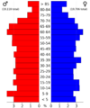
Population pyramid for Des Moines County in 2022

See also
 In Spanish: Condado de Des Moines para niños
