
St Marys, New South Wales facts for kids
Quick facts for kids St MarysSydney, New South Wales |
|||||||||||||||
|---|---|---|---|---|---|---|---|---|---|---|---|---|---|---|---|
St_Marys_Church_St_Marys_035a.jpg)
St Mary Magdalene Anglican Church
|
|||||||||||||||
| Postcode(s) | 2760 | ||||||||||||||
| Elevation | 37 m (121 ft) | ||||||||||||||
| Location | 45 km (28 mi) west of Sydney CBD | ||||||||||||||
| LGA(s) | City of Penrith | ||||||||||||||
| State electorate(s) | Londonderry | ||||||||||||||
| Federal Division(s) | Lindsay | ||||||||||||||
|
|||||||||||||||
St Marys is a lively suburb located in western Sydney, New South Wales, Australia. It's about 45 kilometres west of the main city centre. This area is part of the City of Penrith local government area.
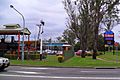
St Marys is bordered by two creeks: South Creek to the west and Ropes Creek to the east. A train line, the Western train line, runs through the middle, splitting the suburb into two parts. The northern part of St Marys is mostly industrial, with businesses like car workshops, factories, and storage places. The southern part is where most of the shops and homes are. Here, Queen Street is the main shopping area, with other shopping centres, a town square, a swimming pool, and schools nearby.
Contents
History of St Marys
The area now known as St Marys was first called South Creek. This name came from the creek that flows through the area. Early European settlers built their homes and farms along the creek because it provided a steady water supply. The land was also good for farming.
One of the first businesses here was the Bennett coach and wagon works. They made horse-drawn wagons, which were very important for transport in Sydney back then. You can still see three of these old wagons on display at South Creek Park today.
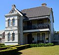
The suburb got its current name from the St Mary Magdalene Church. This church was built between 1837 and 1840. It was designed to look like a church in Cornwall, England, with the same name. The foundation stone for the church was laid in 1837. It's one of the oldest churches in New South Wales that is still used regularly. Many important people, including the wife of Philip Gidley King, an early Governor of New South Wales, are buried in the church cemetery. The land for the church was given by King's son.
The area was officially named St Marys when the post office opened on 1 October 1840. The land was once part of a large grant given to Mary Putland. She was the daughter of Governor William Bligh, famous for the mutiny on the HMS Bounty.
St Marys has a long history of industry and farming. It used to have tanneries (places that make leather) and even factories that made ammunition for the Australian Defence Industries.
Two other important old homes in the area are Mamre and Werrington House. Mamre was built around 1830 for Samuel Marsden, a well-known figure in early Australian history. Werrington House was built by the Lethbridge family around 1829–32. Both are very old and important buildings.
Today, St Marys is home to the local branch of the Vietnam Veterans Association and the St Marys & District Historical Society.
St Marys Council
St Marys used to have its own local council, called the Municipality of St Marys. This council started in 1890. However, in 1949, it joined with the Penrith council. Now, the City of Penrith looks after St Marys. You can find a Penrith City Council office and a library on Queen Street. The St Marys & District Historical Society, which is like a local museum, is open to visitors on Wednesdays and Saturdays.
Heritage Sites
St Marys has several places that are listed for their historical importance. These include:
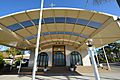
- The St Marys railway station
- The St Marys Magdalene Church
- Bronte House
- Mimosa House
Gallery
-
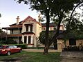
Italianate house, known as 'Bronte', built in 1889 for James Bennet Jr, a local wagon maker.
-
Greek Orthodox Church, Hobart Street. It also has a Greek-language school.
-
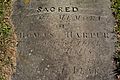
A grave from 1818 in the cemetery of St Mary's Anglican Church.
-
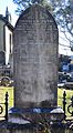
Graves of members of the King family in St Mary's Church cemetery.
-
St Marys RSL club.
-
Mimosa, a Victorian-style house built for Andrew Thompson, a local tanner.
-
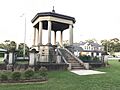
St Marys War Memorial, honouring veterans from various wars.
-
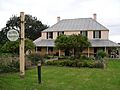
Mamre Homestead, once owned by Samuel Marsden.
-
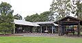
The outdoor Bennett Wagon exhibit at South Creek park.
-
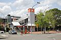
The southern entrance of St Marys train station after its renovation.
-
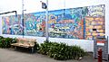
One of two historical murals near Queen Street, showing local history.
-
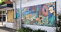
Another historical mural in St Marys, featuring a poem and local landmarks.
-
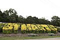
A landmark decorative hedge that spells 'St Marys'.
-
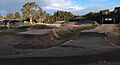
A BMX pump race track next to Blair Oval.
-
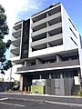
A new multi-storey apartment building in St Marys.
-
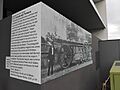
A graphic and caption showing one of James Bennett's wagons.
-

A memorial in Lang Park for workers of the St Marys munitions factory during World War II.
Italianate_house_Gidley_Street_St_Marys.jpg)
Greek_Orthodox_Church_St_Marys-1.jpg)
St_Marys_Church_St_Marys_017.jpg)
St_Marys_Church_St_Marys_026a.jpg)


People of St Marys
According to the 2021 census, there were over 13,000 people living in St Marys.
- About 4.6% of the people are Aboriginal and Torres Strait Islander people.
- Many people have Australian (23.5%) or English (22.0%) backgrounds. Other common backgrounds include Filipino, Irish, and Scottish.
- Most people (56.9%) were born in Australia. Other countries of birth include the Philippines, New Zealand, India, England, and Fiji.
- While most people speak only English at home (59.0%), many other languages are also spoken. These include Arabic, Tagalog, Samoan, and Hindi.
- For religion, the most common responses were Catholic (25.6%), No Religion (23.0%), and Anglican (9.4%).
Industrial Area
The northern part of St Marys is a busy industrial area. It's home to many businesses, especially those related to cars. You'll find car wreckers, repair shops, tyre shops, and car dealerships here.
There are also facilities that handle waste. For example:
- Cleanaway St Marys Liquid Waste Services helps dispose of and treat waste from homes and businesses.
- Penrith City Council has a Community Recycling Centre. This is where people can drop off hazardous household waste safely.
- Sydney Water has a large water treatment plant. It processes a huge amount of water every day!
Commercial Area
The main shopping and business area in St Marys is in the southern half, especially along Queen Street. Here you'll find a mix of big chain stores and smaller local shops. There are also some businesses near the train station and along the Great Western Highway.
St Marys Village Shopping Centre
The St Marys Village Shopping Centre is a popular place to shop. It has a Woolworths, a Target, and over 40 other specialty stores. It's easy to shop here because everything is on one level with plenty of parking.
Station Plaza
There used to be another shopping centre called Station Plaza. It had a Coles supermarket and other shops. It was located right across from the St Marys train station. However, this plaza was taken down in early 2023. This was done to make way for the new Metro Station, which is part of a big development plan for the area.
Hotels
St Marys has a few hotels and pubs. The St Marys Hotel on Queen Street opened in 1955. Another well-known place is The Wagon Wheel Hotel. Its name comes from the old 'Bennet's Coach & Waggon Works' business. On the north side of St Marys, you can find the Holiday Inn, which is next to the St Marys leagues club.
Arts and Culture
St Marys has a growing arts scene. You can see many colourful murals painted by different artists along Queen Street. These murals often show parts of the suburb's history and landmarks. You can even follow a "street art trail" to see them all!
Coachmans Park, in the middle of Queen Street, is a place for fun events. They often hold outdoor concerts, holiday celebrations, and family-friendly activities here.
The St Marys Corner Community and Cultural Precinct, also known as 'The Corner', is another important spot. It has an arts and crafts studio, a community centre, and the Nepean Multicultural Access organization. The building that used to be the local council chambers now houses the St Marys & District Historical Society. This society acts as the suburb's museum, filled with old photos, displays, and items that show what life in St Marys was like in the past.
The Nepean Multicultural Access centre helps people from different cultural backgrounds. They offer classes like English conversation, and activities such as pottery, painting, and gentle exercise.
Fun and Recreation
St Marys offers many places for activities and leisure:
- Don Bosco Youth Centre: This is a multi-sport centre with indoor soccer, basketball courts, table tennis, snooker, and trampolines.
- Ripples Leisure Centre: Here you'll find indoor and outdoor swimming pools, a fitness centre, and hydrotherapy. Nearby, there are also outdoor tennis courts and a BMX pump racetrack.
- Go Bananas Family Entertainment Centre: An indoor soft playground and early learning centre for younger kids.
- Skypeak Adventures: An outdoor adventure course with aerial obstacles high in the trees.
- St Marys Indoor Shooting Centre: An indoor range for firearms and archery.
- National Indoor Sports/St Marys Indoor Sports and Recreation: Indoor courts you can hire for sports like netball, soccer, and football.
Close by, in the suburb of Werrington, is the Troy Adams Archery Field. The Penrith City Archers club uses this field and welcomes archers of all skill levels.
Getting Around St Marys
The M4 Motorway runs along the southern edge of St Marys. You can get on and off the motorway at Mamre Road. The Great Western Highway is the main road that goes east to west through the suburb.
St Marys also has a regular train service. The St Marys station is a major hub where you can catch trains, buses, and taxis.
North of St Marys is Dunheved, which is a big industrial and business area. Years ago, there was a special train line that went from St Marys station to Dunheved and then to Ropes Creek. This line was built to serve the old munitions factories. While the line is no longer used, it's part of the area's history.
Schools in St Marys
St Marys has several schools for different age groups:
- St Marys Primary School
- South St Marys Public School
- Kurambee School (for Special Education)
- Our Lady of the Rosary Primary School
- St Marys Senior High School
