
Edinburgh town walls facts for kids
Quick facts for kids Edinburgh town walls |
|
|---|---|
| Edinburgh, Scotland | |

Remains of the bastion known as the 'Flodden Tower' with Edinburgh Castle behind and the Telfer Wall on the right
|
|

Map showing the town walls, overlaid on the present-day streets
Key: Orange: King's Wall, Red: Flodden Wall, Purple: Telfer Wall A: Edinburgh Castle, B: Flodden Tower, C: Greyfriars Kirkyard; D: site of Netherbow Port, E: Waverley station Blue shading: approximate extent of Nor Loch |
|
| Site information | |
| Condition | Some sections remain to full height |
| Site history | |
| Built | 15th to 17th century |
| Materials | Stone |
| Demolished | Parts demolished from mid 18th century |
Since the 12th century, the city of Edinburgh, Scotland, has had several town walls. The first wall, called the King's Wall, was built in the mid-1400s. Later, in the 1500s, the much larger Flodden Wall was put up after the Scottish army lost a big battle at Flodden in 1513. In the early 1600s, the Telfer Wall extended these defenses even further.
These walls had many gates, known as "ports." The most important one was the Netherbow Port, located halfway along the Royal Mile. This gate allowed people to enter from Canongate, which was a separate town back then. The walls were not always great at defending the city. They were often used more to control trade, collect taxes on goods, and stop smugglers. By the mid-1700s, the walls were no longer needed for defense or trade. People started tearing down parts of them, including the Netherbow Port in 1764. Today, some parts of these three walls still stand, but none of the original gates remain.
Contents
Why Edinburgh Needed Walls
Edinburgh officially became a royal burgh (a special type of town) around 1125, thanks to King David I of Scotland. This meant the town could hold markets and collect taxes on goods brought in to be sold. So, it's likely that some kind of boundary, perhaps a wooden fence or a ditch, was built around this time.
To the north of Edinburgh, there was a large lake called the Nor Loch. This lake was created in the early 1400s where Princes Street Gardens are now. It acted as a natural defense. Edinburgh Castle, built on a high, rocky hill, protected the city from the west. Because of these natural barriers, walls were mainly needed on the south and east sides of the town. Early records mention gates on the west side in 1180, on the south side in 1214, and the Netherbow Port in 1369.
The King's Wall
The King's Wall is first mentioned in records from 1427. In 1450, King James II gave permission for the people of Edinburgh to build strong defenses for their town. He wanted them to protect themselves from "enemies of England." This made Edinburgh one of only three Scottish towns to have stone walls during the Middle Ages. The other two were Stirling and Perth.
In 1472, King James III even ordered that houses built too close to or outside the wall should be torn down. This was to make sure the defenses could be strengthened. The King's Wall ran along the south side of the Royal Mile, above the Cowgate. It stretched from the Castle Hill in the west almost to where St Mary's Street is today. The wall then turned to cross the Royal Mile. This early wall enclosed a small area, only about 0.8 by 0.4 kilometers (about half a mile by a quarter mile). It had two main gates: the Upper Bow (near what is now Victoria Street) and the Nether Bow (on the Royal Mile). There were also smaller side gates called posterns.
The Flodden Wall

In 1513, King James IV led an army into England. At the Battle of Flodden, the Scottish army was badly defeated, and King James was killed. People in Edinburgh expected an English invasion, so they decided to build a new, stronger town wall. This new wall also helped control smuggling and collect taxes.
Construction of the Flodden Wall began in 1514 and finished in 1560. It was usually about 1.2 meters (4 feet) thick and up to 7.3 meters (24 feet) high. The Flodden Wall started at the south side of Edinburgh Castle. It ran south across the west end of the Grassmarket, where the West Port gate was. It then went uphill along the Vennel, where a watchtower still stands today. The wall continued east, wrapping around Greyfriars Kirkyard, past the Bristo Port and Potterow Port. It then went past the Kirk o' Field (where the Old College is now) and along Drummond Street. It turned north at the Pleasance to enclose the Blackfriars Monastery. The Cowgate Port was at the bottom of the Pleasance.
At the Netherbow, where St Mary's Wynd and Leith Wynd met, stood the Netherbow Port. This was the main gate between the High Street and the Canongate. From Leith Wynd, the wall continued west to the Nor Loch, ending at the New Port. The Flodden Wall enclosed an area of nearly 57 hectares (140 acres). This remained the city's boundary until the 1700s. In 1560, about 10,000 people lived within these walls.

The Flodden Wall had six main gates:
- West Port: Built in 1514 at the west end of the Grassmarket.
- Bristo Port: Built around 1515 on Bristo Street, near Greyfriars Kirk.
- Potterrow Port: Near the Kirk o' Field.
- Cowgate Port: On the Cowgate, near the Blackfriars Monastery.
- Netherbow Port: The main gate between the High Street and the Canongate.
- New Port: At the foot of Halkerston's Wynd, giving access north.
The Netherbow Port was the only one that looked like a large, strong gateway. It had a wide arch with two round towers. In 1571, a clock tower with a stone spire was added above the gateway.
Military Events at the Walls

Even though the English invasion expected after Flodden didn't happen, the 1500s were a difficult time in Scotland. In 1544, an English force led by the Earl of Hertford attacked Scotland. On May 6, his soldiers used their cannons to blow open the Netherbow Port. The city was then burned for three days.
More troubles happened during and after the reign of Mary, Queen of Scots (1542–1567). In 1571, Edinburgh was held by supporters of Queen Mary and was attacked by forces loyal to the young King James VI. The walls were repaired, and the Netherbow was blocked off. Nearby houses were torn down to improve defenses. The famous siege gun Mons Meg was even used to attack houses outside the wall where enemy snipers were hiding. The attackers couldn't get in and left on May 20.
The defenses were strengthened again for a second attack in October. By this time, only 10% of Edinburgh's people remained in the city. The attackers had only seven cannons, and while they did manage to break through the Flodden Wall, the inner defenses were too strong. The attack was lifted again on October 21. A blockade of the town continued until July 1572. The castle, however, remained under siege until May 1573, when it was finally taken by English cannons.
The Telfer Wall

In 1618, the city council bought land west of Greyfriars Kirk. Between 1628 and 1636, this land was enclosed by the Telfer Wall. Most of this land was later sold to the George Heriot's Trust for building George Heriot's Hospital.
The Telfer Wall was made of rough stone. It ran south from the Flodden Tower in the Vennel to Lauriston Place. It then turned east to Bristo Street, where it connected back to the Bristo Port in the Flodden Wall. The Telfer Wall was named after its main mason, John Taillefer.
Later History and Demolition
By the 1600s, the King's Wall was mostly hidden by newer buildings. In 1650, the Flodden and Telfer walls were made stronger, and places for cannons were built. This was because people feared an English attack during the English Civil War. The four decorative tops of the Netherbow Port were even removed to make way for cannons.
More cannon positions were built in 1715 during the Jacobite uprising. In 1736, the British government wanted to punish Edinburgh after a mob killed Captain John Porteous. The House of Lords first demanded the Netherbow Port be torn down, but the city resisted, and the House of Commons changed it to a fine.
When the city was threatened by the Jacobite rising of 1745 (led by Bonnie Prince Charlie), volunteers were raised to defend the city. However, when Bonnie Prince Charlie's troops arrived, the city was not well-guarded. On September 17, a group of Highlanders rushed the Netherbow Port as the gates were opened. Edinburgh was captured without a fight.

Demolition of the walls began soon after the Jacobite threat ended in 1746. Parts of the Telfer Wall were torn down in 1762 because they were blocking traffic. The Netherbow Port was removed in 1764 for the same reason. The West Port and Potterow Port were removed in the 1780s. By this time, the New Town was being built, and the old walls were no longer needed.
Many sections of the wall were lost as new buildings were constructed. For example, the Old College (built from 1789) and the museum in Chambers Street (built from 1861) were built over parts of the wall. In the mid-1850s, two sections of the neglected town wall collapsed.
Surviving Parts of the Walls
Not much remains of Edinburgh's very first defenses. Very little of the King's Wall survives, though some parts might be inside later buildings. A section of wall in Tweeddale Court, on the south side of the Royal Mile, might be part of the eastern King's Wall. It is 6 meters (20 feet) high and has no openings, suggesting it was for defense.

Four sections of the Flodden Wall still exist:
- North and south of the Grassmarket: The wall runs next to Granny's Green Steps and is part of later buildings. A line of granite paving across the Grassmarket shows where the wall once stood.
- In the Vennel: The last remaining watchtower, sometimes called the Flodden Tower, is here. It has two walls with openings for cannons.
- In Greyfriars Kirkyard: Sections of the Flodden Wall can be seen here, decorated with old tombstones.
- Along Drummond Street and the Pleasance: This is the longest section, which originally enclosed the Blackfriars Monastery.
The spot where the Netherbow Port stood is marked with an outline of brass blocks at the corner of the Royal Mile and St Mary's Street.

There are two remaining sections of the Telfer Wall:
- Along Heriot Place: This section runs from the Flodden Tower and forms the western boundary of George Heriot's School.
- The south wall of Greyfriars Kirkyard: This is the only other remaining section.
Most of the surviving sections of the walls are protected as scheduled monuments, which means they are important historical sites. The walls are also part of the Edinburgh Old Town World Heritage Site.
Images for kids
-
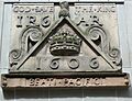
James VI tablet from the demolished Netherbow Port

| Point | Coordinates (links to map & photo sources) |
Notes |
|---|---|---|
| King's Wall in Tweeddale Court | 55°57′01″N 3°11′04″W / 55.95021°N 3.18455°W | |
| Flodden Wall at Granny's Green | 55°56′51″N 3°11′53″W / 55.9475°N 3.19798°W | |
| Flodden Tower | 55°56′46″N 3°11′49″W / 55.94622°N 3.19698°W | |
| Flodden Wall in Greyfriars Kirkyard | 55°56′48″N 3°11′36″W / 55.9466°N 3.19332°W | |
| Flodden Wall markers in Forrest Road | 55°56′47″N 3°11′28″W / 55.94643°N 3.19111°W | |
| Flodden Wall at Drummond Street/Pleasance | 55°56′54″N 3°10′56″W / 55.94841°N 3.18236°W | |
| Netherbow Port | 55°57′02″N 3°11′03″W / 55.95065°N 3.1843°W | |
| Telfer Wall at Heriot Place | 55°56′45″N 3°11′46″W / 55.94571°N 3.19602°W | |
| Telfer Wall at Greyfriars Kirkyard | 55°56′43″N 3°11′31″W / 55.94531°N 3.19191°W |
