Edwards County, Kansas facts for kids
Quick facts for kids
Edwards County
|
|
|---|---|

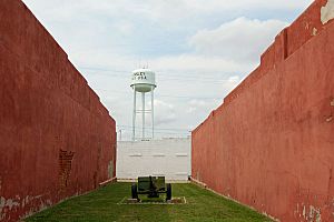
Watertower in Kinsley (2009)
|
|

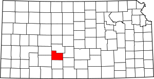
Location within the U.S. state of Kansas
|
|
 Kansas's location within the U.S. |
|
| Country | |
| State | |
| Founded | March 18, 1874 |
| Named for | W. C. Edwards |
| Seat | Kinsley |
| Largest city | Kinsley |
| Area | |
| • Total | 622 sq mi (1,610 km2) |
| • Land | 622 sq mi (1,610 km2) |
| • Water | 0.1 sq mi (0.3 km2) 0.01%% |
| Population
(2020)
|
|
| • Total | 2,907 |
| • Density | 4.7/sq mi (1.8/km2) |
| Time zone | UTC−6 (Central) |
| • Summer (DST) | UTC−5 (CDT) |
| Area code | 620 |
| Congressional district | 4th |
Edwards County is a county in Kansas. Its main city and county seat is Kinsley. In 2020, about 2,907 people lived here. The county started in 1874. It was named after W. C. Edwards, an early settler from Hutchinson. He owned a lot of land in the area.
Contents
History of Edwards County
Edwards County was created in 1873. It was named after W. C. Edwards. He was an important early settler. Mr. Edwards built the first brick building in Kinsley.
N.C. Boles became the first postmaster in the county. A post office opened in Kinsley in 1873. Kinsley was first called Petersboro. The town's current name honors E.W. Kinsley. He was from Boston. He helped pay for the first church building. It was a Congregationalist church. It was finished in 1875.
In 1874, a huge number of grasshoppers ate all the crops. Many families had nothing to eat. The county leaders asked the Governor for help. They wanted work programs for people. This would help families earn money instead of just getting handouts.
In its early years, Kinsley had some challenges. There were two planned train robberies. A bank was also robbed in 1882. The County Treasurer was involved. He was removed from his job.
Geography of Edwards County
Edwards County covers about 622 square miles. Most of this area is land. Only a tiny part is water.
Rivers and Features
The Arkansas River flows through Edwards County. It enters from the southwest. It then goes towards Pawnee County. This is near U.S. Route 56.
Main Roads in Edwards County
Three major U.S. Routes cross Edwards County. All of them meet in Kinsley.
- U.S. Route 50 goes east to west. It passes Belpre and Lewis. Then it joins with U.S. Route 56 in Kinsley. The road then goes through Offerle. It continues west into Ford County.
- U.S. Route 183 runs from the south. It comes from Kiowa County. It meets U.S. 56 in Kinsley. They travel together to Pawnee County.
- K-19 starts near Belpre. It goes north into Pawnee County.
Neighboring Counties
Edwards County shares borders with these counties:
- Pawnee County (north)
- Stafford County (east)
- Pratt County (southeast)
- Kiowa County (south)
- Ford County (southwest)
- Hodgeman County (northwest)
People of Edwards County
| Historical population | |||
|---|---|---|---|
| Census | Pop. | %± | |
| 1880 | 2,409 | — | |
| 1890 | 3,600 | 49.4% | |
| 1900 | 3,682 | 2.3% | |
| 1910 | 7,033 | 91.0% | |
| 1920 | 7,057 | 0.3% | |
| 1930 | 7,295 | 3.4% | |
| 1940 | 6,377 | −12.6% | |
| 1950 | 5,936 | −6.9% | |
| 1960 | 5,118 | −13.8% | |
| 1970 | 4,581 | −10.5% | |
| 1980 | 4,271 | −6.8% | |
| 1990 | 3,787 | −11.3% | |
| 2000 | 3,449 | −8.9% | |
| 2010 | 3,037 | −11.9% | |
| 2020 | 2,907 | −4.3% | |
| 2023 (est.) | 2,733 | −10.0% | |
| U.S. Decennial Census 1790-1960 1900-1990 1990-2000 2010-2020 |
|||
In 2000, there were 3,449 people in Edwards County. They lived in 1,455 households. Most people were White (about 92.5%). About 9.7% of the population was Hispanic or Latino.
About 28.7% of households had children under 18. Most households (56.3%) were married couples. About 32% of households were single people. Many older adults (65 or older) lived alone.
The average age in the county was 41 years old. About 24.6% of the people were under 18. About 20.8% were 65 or older.
Education in Edwards County
Students in Edwards County attend schools in these districts:
- Kinsley-Offerle USD 347
- Lewis USD 502
Communities in Edwards County
Edwards County has several cities and smaller communities.
Cities
Unincorporated Communities
These are smaller places without their own city government:
Townships
Edwards County is divided into ten smaller areas called townships. The city of Kinsley is separate from these townships for government purposes.
See also
 In Spanish: Condado de Edwards (Kansas) para niños
 | Janet Taylor Pickett |
 | Synthia Saint James |
 | Howardena Pindell |
 | Faith Ringgold |


