
Ellicott City, Maryland facts for kids
Quick facts for kids
Ellicott City, Maryland
|
|
|---|---|

Main Street in Historic Ellicott City
|
|
| Nicknames:
"E.C.", "Old Ellicott City", "Old Ellicott", "Historic Ellicott City"
|
|
| Motto(s):
"E.C. Strong"
|
|

Location of Ellicott City, Maryland
|
|
| Country | |
| State | |
| County | Howard |
| Founded | 1772 |
| Incorporated | 1867–1935 |
| Historic District | 1973–present |
| Founded by | John, Andrew, and Joseph Ellicott |
| Government | |
| • Type | County council |
| Area | |
| • Total | 30.13 sq mi (78.04 km2) |
| • Land | 30.01 sq mi (77.72 km2) |
| • Water | 0.12 sq mi (0.32 km2) |
| Elevation | 180 ft (55 m) |
| Population
(2020)
|
|
| • Total | 75,947 |
| • Density | 2,530.98/sq mi (977.22/km2) |
| Time zone | UTC−5 (Eastern (EST)) |
| • Summer (DST) | UTC−4 (EDT) |
| ZIP Codes |
21041–21043
|
| Area code(s) | 410, 443, and 667 |
| FIPS code | 24-26000 |
| GNIS feature ID | 0584282 |
Ellicott City is a community in Howard County, Maryland, United States. It's also the county seat, which means it's where the county government is located. Ellicott City is part of the larger Baltimore metropolitan area. In 2020, about 75,947 people lived there. This makes it the most populated county seat in the U.S. that isn't officially a city.
The historic part of Ellicott City is found in the valleys of the Patapsco and Tiber rivers. This area is often called "Historic Ellicott City" or "Old Ellicott City." This helps people tell it apart from the newer neighborhoods around it. The historic district is home to the Ellicott City Station. This train station was built in 1830. It is the oldest surviving train station in the United States. It was the first stop on the original B&O Railroad line.
Contents
History of Ellicott City
Major Floods in Ellicott City
Ellicott City is located near the Patapsco River and Tiber Creek. This means it often experiences floods. These floods have greatly shaped the town's history. They have destroyed businesses and even caused deaths.
Some major floods happened in 1817, 1837, 1868, 1901, 1917, 1923, 1938, 1942, 1952, 1956, 1972, 1975, 1989, 2011, and 2016. The 1868 flood was very bad. It washed away 14 houses and killed many people. Several mills and homes were destroyed.

In 1923, floods went over bridges. In 1952, an eight-foot wall of water swept through shops. The 1956 flood also caused a lot of damage. A very bad flood happened in 1972 because of Hurricane Agnes. Ellicott City was seriously damaged. The Patapsco River valley flooded 14.5 feet high. It destroyed a bridge and flooded Main Street.
On September 27, 1975, Hurricane Eloise caused a 9-foot flood. Floods also happened on September 22, 1989, from Hurricane Hugo. On September 7, 2011, Tropical Storm Lee caused an 11-foot flood.
The 2016 Flood
On July 30, 2016, a big storm hit Ellicott City. Six inches of rain fell in just two hours. This caused a flash flood that severely damaged the historic area. Main Street was hit especially hard. Many homes, roads, and businesses were destroyed. The town's famous clock was also ruined. Two people died in this flood. The state declared a state of emergency.
Early Mills and Farming
In 1771, three Quaker brothers from Pennsylvania came to the area. Their names were John, Andrew, and Joseph Ellicott. They chose this spot because it was far up the Patapsco River. This was as far as large ships could travel. They bought land and started "Ellicott's Mills." This town became one of the biggest milling and manufacturing centers in the East.
The Ellicott brothers built many things. They had sawmills, metalworking shops, stables, and grain mills. They also helped change farming in the area. They convinced farmers to grow wheat instead of tobacco. They also introduced a fertilizer called Plaster of Paris. This helped make the soil healthy again. By 1840, the Ellicott family sold their businesses.

The Railroad Arrives
In 1830, Ellicott's Mills became very important for trains. It was the first stop outside Baltimore for the Baltimore and Ohio Railroad. This was the first railroad in the country that carried both goods and people. The Ellicott City Station was built there. It is still standing today and is a museum. It is known as the "Oldest surviving railroad station in America."
A famous race happened in August 1830. It was between Peter Cooper's steam engine, the Tom Thumb, and a horse-drawn rail car. The horse won because the Tom Thumb had a problem. But this race showed that steam engines would soon be very important. The railroad became a key part of Ellicott City's economy.
During the Civil War in 1861, Ellicott's Mills was a busy place. Union Army troops were stationed there. Homes and churches in the town were used as hospitals for wounded soldiers.
Becoming a City and Losing its Charter
In 1867, Ellicott's Mills officially became a city. It got its own local government with a mayor and council. Its name was changed to "Ellicott City." The first Mayor was E.A. Talbot.
Howard County built its first jail in Ellicott City in 1878. It was called the Ellicott City Jail. It could hold 12 people. It was used until a new jail opened in 1983.
In 1882, Ellicott City passed a law against selling alcohol. This was part of the Temperance movement. This law was later changed to allow sales only in special licensed shops. These shops became a main source of tax money for the town.
Trolley service came to Ellicott City in 1899. These electric streetcars ran until 1955. The old rail line is now a hiking trail.
Ellicott City lost its city charter in 1935. This meant it was no longer an officially incorporated city. This happened because the town lost tax money from alcohol sales during Prohibition. Citizens protested because taxes shifted to them.
Modern Development
In 1955, the first big housing area, Normandy Heights, was built. The first major shopping center, Normandy Shopping Center, also opened.
Ellicott City has been named one of the "20 Best Places to Live in the United States" four times. This was by Money and CNNMoney.com. In 2009, Newsmax magazine also listed Ellicott City as one of the "Top 25 Most Uniquely American Cities and Towns." They liked its historic Main Street.
In 2012, a CSX coal train derailed in Ellicott City. Two 19-year-old girls sitting on a railroad bridge were killed.
In 2015, Ellicott City was recognized as a Tree City USA. This means it has a good plan for managing its trees.
Koreatown
Ellicott City has a large Korean population. Many Korean-owned businesses and restaurants are along its Route 40 corridor. In 2017, Governor Larry Hogan named a part of Route 40 "Korean Way." This honored the city's Korean culture. Ellicott City's Koreatown has helped bring new life to shopping centers in the area.
Geography of Ellicott City
Ellicott City covers about 30.13 square miles (78.04 square kilometers). Most of this area is land. People say Ellicott City is built on seven hills.
The oldest part of town is Main Street. It is the heart of the Historic District. Other small areas within the district include Tongue Row and the West End.
Ellicott City is generally bordered by the Patapsco River to the north and east. Other borders include Bonnie Branch and Maryland Route 108 to the south. Manor Lane and Marriottsville Road are to the west. Many neighborhoods make up Ellicott City. These include Oella, Ilchester, Centennial, and Normandy.
Climate
Summers in Ellicott City are hot and humid. Thunderstorms happen often. Spring and fall have nice temperatures. Winters are usually chilly, with light rain or snow. Rainfall is spread out evenly through the year. About 3 to 5 inches of rain fall each month.
| Climate data for Ellicott City, MD | |||||||||||||
|---|---|---|---|---|---|---|---|---|---|---|---|---|---|
| Month | Jan | Feb | Mar | Apr | May | Jun | Jul | Aug | Sep | Oct | Nov | Dec | Year |
| Record high °F (°C) | 78 (26) |
80 (27) |
90 (32) |
95 (35) |
97 (36) |
101 (38) |
105 (41) |
103 (39) |
101 (38) |
95 (35) |
83 (28) |
77 (25) |
105 (41) |
| Mean daily maximum °F (°C) | 42 (6) |
46 (8) |
55 (13) |
67 (19) |
76 (24) |
84 (29) |
88 (31) |
86 (30) |
79 (26) |
68 (20) |
57 (14) |
46 (8) |
66 (19) |
| Mean daily minimum °F (°C) | 23 (−5) |
25 (−4) |
32 (0) |
41 (5) |
51 (11) |
60 (16) |
64 (18) |
63 (17) |
56 (13) |
44 (7) |
35 (2) |
27 (−3) |
43 (6) |
| Record low °F (°C) | −18 (−28) |
−16 (−27) |
−4 (−20) |
12 (−11) |
27 (−3) |
34 (1) |
44 (7) |
41 (5) |
29 (−2) |
18 (−8) |
3 (−16) |
−14 (−26) |
−18 (−28) |
| Average precipitation inches (mm) | 3.74 (95) |
3.01 (76) |
4.30 (109) |
3.52 (89) |
4.78 (121) |
4.11 (104) |
3.85 (98) |
3.53 (90) |
4.09 (104) |
3.44 (87) |
3.73 (95) |
3.53 (90) |
45.63 (1,159) |
| Source: Intellicast | |||||||||||||
People in Ellicott City
| Historical population | |||
|---|---|---|---|
| Census | Pop. | %± | |
| 1970 | 17,455 | — | |
| 1980 | 21,784 | 24.8% | |
| 1990 | 41,396 | 90.0% | |
| 2000 | 52,978 | 28.0% | |
| 2010 | 65,834 | 24.3% | |
| 2020 | 75,947 | 15.4% | |
| source: | |||
| Population by Race in Ellicott City Maryland (2020) | ||
| Race | Population | % of Total |
|---|---|---|
| Total | 75,947 | 100 |
| White | 37,723 | 49.7 |
| Asian | 24,675 | 32.5 |
| African American | 7,279 | 9.6 |
| Two or More Races | 4,857 | 6.4 |
| Other | 1,249 | 1.6 |
| American Indian | 150 | 0.2 |
| Pacific Islander | 14 | < 0.1% |
| Hispanic (any race) | 3,409 | 4.5 |
In 2010, there were 65,834 people living in Ellicott City. About 23,734 households were counted. The population density was about 2,188 people per square mile. The racial makeup was mostly White (64.5%) and Asian (22.9%). About 8.5% were African American.
About 39.1% of households had children under 18. Most households (65.2%) were married couples. The average household size was 2.76 people. The median age of people living there was 40.7 years old.
Fun Things to Do in Ellicott City
Haunted History and Tours

Ellicott City is sometimes called one of the most haunted small towns on the East Coast. The Howard County Tourism Council offers a Ghost Tour. This tour visits places that are said to have paranormal activity. Some of these places include old mansions like Lilburn and Mt. Ida. The B&O railroad bridge and the old Ellicott City Firehouse are also on the tour.
Popular Tourist Spots
- Centennial Park: A large park with a lake and trails.
- Ellicott City Station: The oldest surviving train station in America, now a museum.
- Enchanted Forest: A fairy tale-themed amusement park. It closed to the public in the 1990s. Many of its attractions have been moved to Clark's Elioak Farm nearby.
- Shrine of St. Anthony: A peaceful religious site.
- The Chesapeake Shakespeare Company: A theater group that performs Shakespeare's plays.
- Trolley Line Number 9 Trail: A hiking trail on an old trolley line.
Schools in Ellicott City
Ellicott City has several public high schools. These include Mount Hebron High School, Centennial High School, Wilde Lake High School, Howard High School, Marriotts Ridge High School, and River Hill High School. These schools are part of the Howard County Public School System.
There are also many middle schools and elementary schools. Some middle schools are Burleigh Manor and Ellicott Mills. Elementary schools include Veterans and Centennial Lane. There are also private schools like St. John's Parish Day School and Glenelg Country School.
Getting Around Ellicott City
Public Transportation
Ellicott City has bus service provided by the Regional Transportation Agency of Central Maryland (RTA). Route 405 goes from the Columbia Mall to the Miller Branch Public Library. The Maryland Transit Administration also has commuter bus services. The closest train station is Dorsey station. It is about 9 miles away in Elkridge.
Walking and Biking Trails

Many paths and trails are around Ellicott City. The Grist Mill Trail is in Patapsco Valley State Park. It runs along the Patapsco River. This trail connects Ellicott City to Relay. It is known for the Patapsco Swinging Bridge. The Trolley Line Number 9 Trail is also nearby. It connects Ellicott City to Catonsville.
Main Roads
Major roads that go east and west through Ellicott City include:
- Maryland Route 144 (Main Street)
 U.S. Route 40 (Baltimore National Pike)
 Interstate 70: This highway goes from Frederick to Baltimore.
- Maryland Route 103 (Montgomery Road)
Other important highways include:
 U.S. Route 29 (Columbia Pike): This road starts at I-70 and goes south towards Columbia and Washington, D.C..
- Maryland Route 100: This road ends in the southern part of Ellicott City and goes east towards Glen Burnie.
Airports Near Ellicott City
The closest major airport is Baltimore-Washington International Airport. It is about 10 miles southeast of Ellicott City. There is also a smaller airport called Glenair Airport in Glenelg, about 10 miles to the west.
Famous People from Ellicott City
- Jeff Altenburg, a racing car driver
- Edith Clarke, a pioneering electrical engineer
- Frank Cho, a comics writer and artist
- Taylor Cummings, a lacrosse player
- Divine, an actor
- Andy Freed, a radio announcer for the Tampa Bay Rays
- Bryce Hall, a social media personality
- Aaron Maybin, a former professional football player for the New York Jets
- Ken Navarro, a jazz guitarist and composer
- Alexis Ohanian, an internet entrepreneur and investor
- Aaron Russell, a professional volleyball player for the U.S. national team
- Snail Mail, a band with Lindsey Jordan, who went to high school here
- Edward Snowden, known for sharing information from the NSA
- Peter Solomon, a Major League Baseball player
- The Dangerous Summer, an American rock band
- Martha Ellicott Tyson (1795–1873), an author and co-founder of Swarthmore College
Images for kids
-
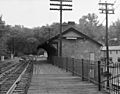
Ellicott City Station, 1970.
-
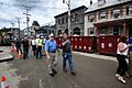
Governor of Maryland Larry Hogan tours Ellicott City after the 2016 floods.
-
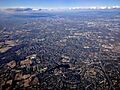
Aerial view of Centennial Lake in 2017.
-
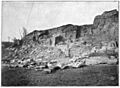
Gaither's Quarry, Ellicott City, photographed around 1898.

.jpg)


See also
 In Spanish: Ellicott City (Maryland) para niños
