Faribault County, Minnesota facts for kids
Quick facts for kids
Faribault County
|
|
|---|---|

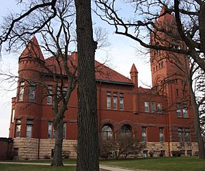
Faribault County Courthouse in Blue Earth
|
|

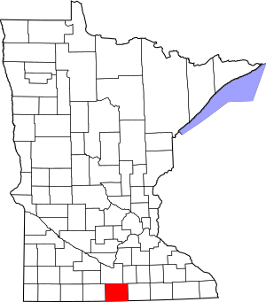
Location within the U.S. state of Minnesota
|
|
 Minnesota's location within the U.S. |
|
| Country | |
| State | |
| Founded | February 20, 1855 |
| Named for | Jean Baptiste Faribault |
| Seat | Blue Earth |
| Largest city | Blue Earth |
| Area | |
| • Total | 722 sq mi (1,870 km2) |
| • Land | 712 sq mi (1,840 km2) |
| • Water | 9.4 sq mi (24 km2) 1.3%% |
| Population
(2020)
|
|
| • Total | 13,921 |
| • Estimate
(2023)
|
13,873 |
| • Density | 19.281/sq mi (7.444/km2) |
| Time zone | UTC−6 (Central) |
| • Summer (DST) | UTC−5 (CDT) |
| Congressional district | 1st |
Faribault County (/ˈfɛərboʊ/ FAIR-boh) is a county in the U.S. state of Minnesota. Think of a county as a large area with its own local government. In 2020, about 13,921 people lived here. The main town, or county seat, where the county government is located, is Blue Earth.
Contents
History
Faribault County was started way back in 1855. It's named after a person named Jean-Baptiste Faribault. He was a French fur trader and an early settler who lived among the Sioux people.
Geography
Faribault County is located in the southern part of Minnesota. Its southern edge touches the northern border of Iowa.
Several rivers flow through the county. The Blue Earth River flows north through the western-central part. It starts in Iowa as two smaller branches, then joins up inside the county. Another branch joins it near the city of Blue Earth. The Maple River flows through the upper central part. The Cobb River also flows through the northeastern part.
The land in the county has gentle, rolling hills. Most of it is used for farming. A special area in the southeast, near Kiester, is called the Kiester Moraine. It was formed by glaciers long ago. The county covers about 722 square miles. Most of this is land, with a small part being water.
Lakes
Faribault County has several lakes. Some of them include:
- Bass Lake (Delavan Twp)
- Hart Lake
- Minnesota Lake
- Rice Lake (Delavan Twp)
- Rice Lake (Foster Twp)
- South Walnut Lake
- Walnut Lake
Airports
The county has two airports:
- Blue Earth Municipal Airport
- Wells Municipal Airport
Major highways
Important roads that help people travel through Faribault County include:
 Interstate 90
 U.S. Highway 169
 Minnesota State Highway 22
 Minnesota State Highway 109
Neighboring counties
Faribault County shares its borders with these other counties:
- Blue Earth County - to the north
- Waseca County - to the northeast
- Freeborn County - to the east
- Winnebago County, Iowa - to the southeast (in Iowa)
- Kossuth County, Iowa - to the southwest (in Iowa)
- Martin County - to the west
Protected areas
One special natural area in the county is:
- Walnut Lake State Wildlife Management Area
Population
| Historical population | |||
|---|---|---|---|
| Census | Pop. | %± | |
| 1860 | 1,335 | — | |
| 1870 | 9,940 | 644.6% | |
| 1880 | 13,016 | 30.9% | |
| 1890 | 16,708 | 28.4% | |
| 1900 | 22,055 | 32.0% | |
| 1910 | 19,949 | −9.5% | |
| 1920 | 20,998 | 5.3% | |
| 1930 | 21,642 | 3.1% | |
| 1940 | 23,941 | 10.6% | |
| 1950 | 23,879 | −0.3% | |
| 1960 | 23,685 | −0.8% | |
| 1970 | 20,896 | −11.8% | |
| 1980 | 19,714 | −5.7% | |
| 1990 | 16,937 | −14.1% | |
| 2000 | 16,181 | −4.5% | |
| 2010 | 14,553 | −10.1% | |
| 2020 | 13,921 | −4.3% | |
| 2023 (est.) | 13,873 | −4.7% | |
| U.S. Decennial Census 1790-1960 1900-1990 1990-2000 2010-2020 |
|||
The population of Faribault County has changed over the years. In 1860, there were about 1,335 people. The population grew a lot by 1900, reaching over 22,000. Since then, the number of people living in the county has slowly decreased. In 2020, about 13,921 people lived there.
Communities
Faribault County has several towns and smaller communities.
Cities
- Blue Earth (This is the county seat)
- Bricelyn
- Delavan
- Easton
- Elmore
- Frost
- Kiester
- Minnesota Lake (Partly in Blue Earth County)
- Walters
- Wells
- Winnebago
Unincorporated communities
These are smaller places that are not officially cities:
- Baroda
- Brush Creek
- Clayton (This is a ghost town, meaning it's no longer inhabited)
- Dell
- Guckeen
- Homedahl (Another ghost town)
- Huntley
- Marna
- Pilot Grove
Townships
Townships are smaller divisions of land within a county. Here are the townships in Faribault County:
- Barber Township
- Blue Earth City Township
- Brush Creek Township
- Clark Township
- Delavan Township
- Dunbar Township
- Elmore Township
- Emerald Township
- Foster Township
- Jo Daviess Township
- Kiester Township
- Lura Township
- Minnesota Lake Township
- Pilot Grove Township
- Prescott Township
- Rome Township
- Seely Township
- Verona Township
- Walnut Lake Township
- Winnebago City Township
Education
Students in Faribault County attend schools in several different school districts:
- Alden-Conger Public School District
- Blue Earth Area Public Schools
- Granada-Huntley-East Chain School District
- Janesville-Waldorf-Pemberton School District
- Maple River School District
- United South Central School District
The county also has two special state-operated schools:
- Minnesota State Academy for the Blind
- Minnesota State Academy for the Deaf
See also
 In Spanish: Condado de Faribault para niños

