Fatu-Hiva facts for kids
Quick facts for kids
Fatu-Hiva
|
|
|---|---|
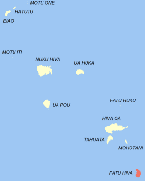
Location of the commune (in red) within the Marquesas Islands
|
|
| Country | France |
| Overseas collectivity | French Polynesia |
| Subdivision | Marquesas Islands |
| Area
1
|
85 km2 (33 sq mi) |
| Population
(2017)
|
612 |
| • Density | 7.20/km2 (18.65/sq mi) |
| Time zone | UTC−09:30 |
| INSEE/Postal code |
98718 /98740
|
| Elevation | 0–1,125 m (0–3,691 ft) |
| 1 French Land Register data, which excludes lakes, ponds, glaciers > 1 km2 (0.386 sq mi or 247 acres) and river estuaries. | |
Fatu-Hiva is the southernmost island in the Marquesas Islands. These islands are part of French Polynesia, which is a territory of France located in the Pacific Ocean. Fatu-Hiva is also the most isolated of the islands where people live. Its closest neighbor is a small island called Motu Nao.
Did you know that Fatu Hiva is also the name of a famous book? It was written by the explorer Thor Heyerdahl. In his book, he shares his experiences from living on the island in the 1930s.
Contents
The Name Fatu-Hiva
The island's name in the local Marquesan language is actually Fatu Iva. It does not have an "h" sound. However, when Europeans first wrote down the name, they added an "h." This might have been because other Marquesan islands like Nuku-Hiva and Hiva-Oa have "Hiva" in their names. Also, in French, the letter "h" is often silent.
Today, Fatu-Hiva is the official spelling. In the 16th century, Spanish explorers called the island Isla Magdalena. This name is rarely used now.
History of Fatu-Hiva
Early Settlers and Island Life
Like other islands in the archipelago, Fatu-Hiva was first settled by Polynesian people. They likely came from areas further west in Polynesia.
The different valleys on the island often had rivalries. Around the mid-1800s, two tribes, the Anainoapa and the Tiu, fought each other. The Tiu tribe lost and left the island on bamboo rafts. They ended up on Napuka Atoll in the Tuamotus, where their descendants still live.
Not much is known about Fatu-Hiva's culture before Europeans arrived. This is because missionaries greatly changed the island's way of life. In 1897, a German explorer named Karl von den Steinen described nine tribes living in different valleys.
Archaeologists have not done many digs on Fatu-Hiva. However, some studies in the 1920s found remains of ceremonial places. These included platforms where people lived and small sacred sites. Unlike other Marquesas islands, people on Fatu-Hiva sometimes mummified their dead. They often buried them inside their homes.
No giant stone statues have been found here. But the island was known for its amazing tattoo artists and wood carvers. Their beautiful works, however, have mostly disappeared over time.
European Discoveries and Visitors
The first European to see Fatu-Hiva was the Spanish sailor Álvaro de Mendaña de Neira. He spotted the island on July 21, 1595. It was the first island he saw in the archipelago. He couldn't land because he couldn't find a safe place to anchor his ship. Mendaña named the islands "Marquesas de Mendoza" to thank the viceroy of Peru who helped his trip.
In 1937 and 1938, the Norwegian adventurer Thor Heyerdahl and his wife Liv lived on Fatu-Hiva. They stayed for about a year and a half. Heyerdahl was studying how animals spread among the Polynesian islands. But he also wanted to live a simple life away from civilization. They first landed in Omoa but found it too modern. So, they moved to Ouia, a valley on the eastern coast that is now empty. After a year and a half, they faced many challenges like mosquitoes, sickness, and bad weather. Heyerdahl wrote about his experiences in a book called Fatu Hiva, the return to nature.
Geography of Fatu-Hiva
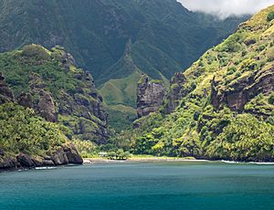
Fatu-Hiva's eastern coast has many narrow valleys. Streams flow through these valleys from the island's center. Between the valleys are cliffs that drop straight into the sea. This makes it hard to travel along the coast. You either have to go over the high mountains or use a boat. The largest valley on this side is at Uia.
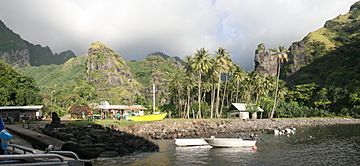
The western coast has two important bays. Hana Vave, also known as the Bay of Virgins, is in the north. It is one of the most beautiful spots in the South Pacific. Near the south is Omoa, a well-protected harbor. There are also several smaller valleys between these two main bays.
The middle of the island is a high, flat area called a plateau. It is mostly covered with tall grasses and pandanus trees. To the south of the plateau is a mountain ridge called Tauauoho. Its highest point is 1,125 meters (3,691 feet) high. This is the highest point on Fatu-Hiva. To the north and northwest, there is another mountain ridge called Fa‘e One, which reaches 820 meters (2,690 feet).
How Fatu-Hiva Was Formed (Geology)
Fatu-Hiva was created by two volcanoes that fit together. The first volcano's crater, called a caldera, is about eight kilometers wide. It has sharp edges made of peaks over 1,000 meters high. This part of the island is between 2.46 and 1.81 million years old.
The second caldera is inside the first one and is three to four kilometers wide. It was formed by a very strong eruption. You can still see amazing basalt columns, like the "statues" in Hanavave Bay, which were formed by mudflows from this eruption. This part of the island is between 1.68 and 1.33 million years old. The main explosion happened about 1.40 million years ago.
The two main villages on the island are located at the edges of the space between these two ancient volcanoes.
Plants and Trees (Flora)
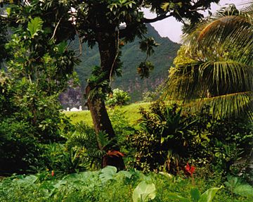
Near the villages and along the coast, people have changed the land a lot to grow food. So, not much of the original plant life is left there. Many native plants in the lower and middle parts of the island might have disappeared long ago. Today, people grow breadfruit, coconut, yam, taro, sweet potatoes, bananas, and other fruits.
The higher parts of the island are covered with mountain rainforests and cloud forests. You can also find tree ferns there. Above 600 meters, grass forests with Metrosideros and Pterophylla marquesana trees are common. However, even these hard-to-reach areas are in danger because wild goats are eating the plants. The tops of the mountains and dry areas are very dry.
Some plants found only on Fatu-Hiva still live in the mountain rainforest. These include Ochrosia fatuhivensis and Melicope fatuhivensis. Pterophylla tremuloides is a shrub that grows on low ridges and cliffs. In 1988, a study found 175 native plants, 21 plants found only on Fatu-Hiva, and 136 plants brought by humans.
Animals of Fatu-Hiva (Fauna)
Fatu-Hiva has many different plants but fewer types of animals. The animals are mostly land and sea birds, insects, butterflies, spiders, and one type of bat. The Fatu Hiva monarch (Pomarea whitneyi) is a bird that lives only on this island.
Because Fatu-Hiva is thought to be free of rats, people are trying to move endangered land birds from other Marquesas islands here. This has worked well for birds like the ultramarine lorikeet, a type of parrot.
How Fatu-Hiva is Governed
Fatu-Hiva is a commune (like a municipality) in French Polynesia. This means it is part of France. It is managed by a local government office in the Marquesas Islands. The main town and administrative center is Omoa, located on the island's southwest side.
The official language is French. The island is part of the European Union.
People and Life on Fatu-Hiva (Demographics)
In 2017, Fatu-Hiva had 633 people living there. The main villages are Omoa, which is the capital, and Hanavave. Most people live by farming, making handicrafts, and from tourism. The island's mountains make it impossible to build an airport. So, you can only reach Fatu-Hiva by boat.
The number of people living on Fatu-Hiva went down in the late 1990s. This was mainly because young people left for two reasons:
- School: There is no high school on the island. Young people have to leave at a young age to continue their studies, first to Hiva Oa, then to Papeete. Many do not come back to Fatu-Hiva after finishing school.
- Jobs: It is hard to find many job opportunities on the island because it is so isolated. Its rough land also stops an airport from being built.
However, since 2007, the population has started to grow again. The villages of Hana Vave, Omoa, and Uia have seen the most growth.
Religion
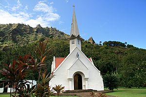
Catholic missionaries brought Christianity to the island in 1877. The Catholic Church has two churches on Fatu-Hiva. These are the Church of Saint Michael in Hanavave and the Church of Our Lady of Peace in Omoa.
Economy and Jobs
Most people on Fatu-Hiva work in the primary sector. This means they get raw materials from nature. Fishing is very important, especially for tuna, mackerel, and swordfish. People also catch crayfish. The island has a cold storage facility. This helps them keep their fish fresh until cargo ships arrive to buy it.
Growing copra (dried coconut meat) is still a big part of the economy. More recently, people have started growing noni fruit. Coffee farming was mostly stopped in the second half of the 20th century. For their own food, people also hunt wild pigs and goats. They gather seafood and lots of fruit. They often share fruit with visitors.
Since the 1960s and 1970s, making handicrafts has grown a lot, thanks to tourism. The island is famous for its tapa. These are traditional cloths made from tree bark. Today, they are still made in the old way, mostly in one color. However, people now use chemical dyes instead of soot for coloring.
The money used on the island is the CFP franc, which is linked to the euro. People mostly live by growing their own food. Selling monoi oil, carvings, and painted bark to tourists from cruise ships and other sailors also brings in some money.
Tourism
Tourism is limited because there is no airport. However, cruise ships do visit the island. There are not many services for tourists. You won't find banks, ATMs, or taxis. There are also only a few places to stay. Fatu-Hiva does not have any beaches for swimming.
There is a three-hour hike between the two villages. It is steep, but it offers amazing views of the island, the ocean, and waterfalls. In Omoa, the Grélet Museum has a collection of local items. These include war clubs, tikis (carved figures), and carved wood bowls.
Infrastructure
Most of the island's 8,400 hectares are home to people living in Omoa and Hanavave villages. These villages are on the west coast. They are connected by a dirt road that goes through the mountains. Omoa is the largest village. It has a Catholic church, a nursery and elementary school, a small shop, a post office, and a satellite telephone.
Fatu-Hiva does not have paved roads between the two villages. The road is very bumpy, especially near Hanavave. Rain often makes the road slippery and dangerous. People often prefer to use a boat to travel between the villages. This trip takes about 15 minutes. There is no harbor dock for large ships and no airfield on the island. It is only safe to land on the coast in the two bays on the west side, where the villages are located.
Fatu Hiva in Books
The island became more famous because of the book of the same name by Thor Heyerdahl. He spent about eight months on the island in 1937 with his first wife, Liv. They wanted to live a simple life, like Robinson Crusoe. They first lived near the west coast in the Omoa Valley. Later, they moved to Ouia on the east coast, which is now empty.
Heyerdahl wrote his first book about his time there in 1938. It didn't sell well at first. Later, after his other books became famous, he rewrote the Fatu Hiva book.
The island also appears in a short story collection by Jack London called "A Son of the Sun." In one story, Fitu-Iva (another name for Fatu-Hiva) is tricked by a con artist. The con artist introduces fake paper money and trades it for valuable items. When the trick is found out, he is punished and sent away from the island.
See also
 In Spanish: Fatu Hiva (isla) para niños
 | Aaron Henry |
 | T. R. M. Howard |
 | Jesse Jackson |


