Fortifications of Plymouth facts for kids
The fortifications of Plymouth are a huge collection of defensive structures built over many centuries. Plymouth is a very important city in England because it has a natural harbour and is home to the United Kingdom's second largest naval base. This means many ships, especially navy ships, use Plymouth. Because of its important location, many forts and walls were built to protect it from attacks, especially from the sea.
In the Middle Ages, the first defences were built around Sutton Harbour, which is on the eastern side of Plymouth Sound. Later, in the 1700s, naval activities moved west to Devonport, near the River Tamar. During the Victorian era, new weapons and technology led to a massive building project. Forts were built all around Plymouth Sound and on the land approaches. Many of these forts were still used by the military well into the 1900s.
Contents
Medieval Defences: Early Walls and Castles
When the Normans took over England, Plymouth was just a tiny village. But by the late 1200s and mid-1300s, kings used Plymouth as a meeting point for their armies before sailing to France. In 1377, the town received money to build fortifications, though we don't know exactly what these first defences looked like.
Plymouth Castle: Protecting the Town
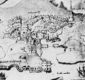
After French raiders attacked Plymouth in 1403, King Henry IV ordered more defences to be built. This led to the creation of a castle with four towers. It overlooked the town and harbour. The townspeople mostly paid for this castle, and the mayor controlled it. Today, only a small part of the castle remains on Lambhay Street, near the Mayflower Steps.
The Barbican: Guarding the Harbour Entrance
Connected to Plymouth Castle was a fort right at the mouth of Sutton Harbour. This area is now called the Barbican district. Old maps show it as a fortified jetty. From here, a large chain could be stretched across the harbour entrance to stop enemy ships from entering.
Tudor Fortifications: New Artillery Towers
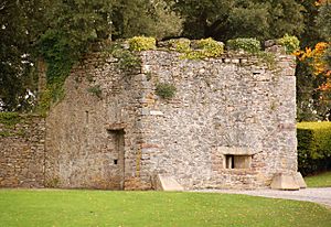
In the early 1500s, six small artillery towers called blockhouses were built around Plymouth Sound. These towers were designed to fire cannons at enemy ships directly in front of them.
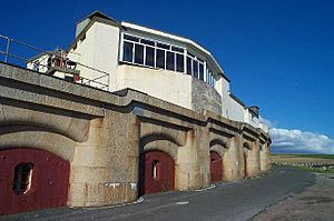
- Fisher's Nose Blockhouse was built on the headland at the eastern end of Plymouth Hoe. It guarded the Cattewater, which is the way into Sutton Harbour. It might have been built in the late 1400s and is now used as a café.
- Mount Edgcumbe Blockhouse is at the entrance to the Hamoaze, the mouth of the River Tamar, on the western side of Plymouth Sound. It was likely built by the Edgcumbe family to protect their lands and can still be visited.
- Devil’s Point Blockhouse is across from Mount Edgcumbe. You can see its outside.
- Firestone Bay Blockhouse in Stonehouse might also have been built by the Edgcumbes. It is now a restaurant.
- Millbay West and Millbay East protected the harbour at Millbay, but they no longer exist.
Elizabethan Works: Drake's Fort
In 1590, the famous explorer Sir Francis Drake was put in charge of improving Plymouth's defences. He first set up temporary gun batteries on the Hoe and on St Anthony's Island (now Drake's Island). Then, he asked for money to build a permanent fort on the Hoe. In 1592, Queen Elizabeth I even put a special tax on fish (pilchards) to pay for it!
This fort, later called Drake's Fort, was built until 1596, after Drake had died. It had two strong bastions on its landward side and included the existing batteries on the Hoe and the Fisher's Nose Blockhouse. Another blockhouse, Queen Elizabeth's Tower, was built nearby.
17th Century Fortifications: Civil War and the Royal Citadel
The Siege of Plymouth: Temporary Defences
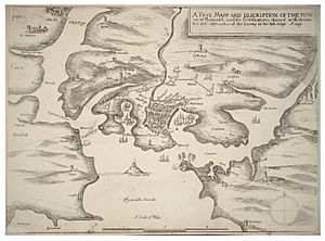
During the English Civil War, Plymouth supported Parliament, while most of Devon and Cornwall supported the Royalists. Because of this, Royalist forces surrounded and attacked Plymouth between 1643 and 1646. The existing forts only protected Plymouth from the sea. So, the town quickly built a ditch and an earthen rampart around itself. They also built triangular forts called redoubts on high ground to the north.
The Royalists also built their own forts facing Plymouth, but they didn't have the big guns needed to break through. The attackers did manage to build a gun battery on the headland later called Mount Batten. This stopped ships from entering Sutton Pool, forcing Plymouth's defenders to use the harbour at Millbay instead.
Mount Batten Tower: A New Stronghold
Built in 1652, Mount Batten Tower is a 30-foot-high circular artillery fort. It stands opposite Fisher's Nose and controls the Cattewater from the south.
The Royal Citadel: A Mighty Fortress
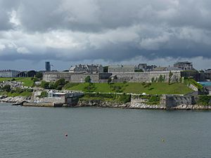
The Royal Citadel was built starting in 1665, designed by Sir Bernard de Gomme. It is a bastion fort located at the eastern end of the Hoe, built right over where Drake's Fort used to be. It is still used by the military today and is home to the 29 Commando Regiment of the Royal Artillery. You can even take guided tours during the summer!
Queen Anne's Battery: A Gun Platform
East of the entrance to Sutton Pool, an open artillery battery was finished in 1667. It was later named after Queen Anne, who was queen from 1702 to 1714. The area where this battery stood is now a marina for boats.
18th Century Fortifications: Protecting the Dockyard
Western Batteries: Guarding the New Dockyard
In 1690, work began on a new Royal Dockyard on the Hamoaze. It was first called Plymouth Dock but later renamed Devonport. To protect this important dockyard, new earthen batteries were built in 1701 at Devil's Point (Stonehouse), Drake's Island, and Cawsand Bay.
Devonport Lines: Land Defences
When the Seven Years' War brought conflict with France and Spain, it was decided to protect the dockyard from attacks by land. A ditch and earthen rampart were built, known as the Dock Lines or later the Devonport Lines. This defence line was about 2,000 yards (1,800 metres) long and included four strong points called bastions and two gateways. A third gate was added later for access to the Torpoint Ferry.
The lines were supported by barracks (military living quarters) behind them, each with its own rampart and bastions. By 1805, 130 guns were placed on these lines. They were completely rebuilt between 1810 and 1816 with stone-faced ramparts and a deeper ditch. These lines were slowly removed and redeveloped in the second half of the 1800s.
Mount Pleasant Redoubt: An Outpost
About 1,000 yards (900 metres) in front of the Dock Lines, a rectangular fort called a redoubt was built at Stoke on top of Mount Pleasant. It was an earthwork with stone walls, protected by a ditch and a drawbridge. You can still see the remains of this redoubt in Mount Pleasant Park.
Maker Redoubts: Defending the Cornish Side
The American Revolutionary War again brought a threat from France and Spain, who were allies of the American colonies. People worried that Plymouth's defences were weak on the Cornish (western) side of Plymouth Sound. Even though simple batteries had been built at Barnpool, Kingsand, Cawsand, and a redoubt at Cremyll, it was thought that an enemy force could set up on the high ground near the village of Maker. This spot overlooked both the Sound and the dockyard.
In August 1779, a fleet of French and Spanish ships anchored off Cawsand Bay but left soon after. For the next three summers, soldiers camped on Maker Heights and built a line of five earthen redoubts along the ridge. During the French Revolutionary Wars, redoubts Number 4 and 5 were rebuilt with stone walls, and a sixth stone redoubt was built at Empacombe in 1807.
The Palmerston Forts: A Ring of Steel
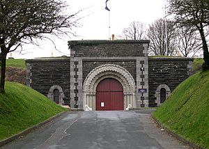
The Palmerston Forts were built because of a military competition with France under Napoleon III. People in Britain worried about a possible invasion. While some forts around Plymouth started in the late 1850s, most were built based on the ideas of the Royal Commission on the Defence of the United Kingdom. This group was set up by Lord Palmerston in 1859.
The forts that were built created two lines of coastal artillery forts to protect Plymouth and the Devonport dockyard from sea attacks. A large semi-circle of other forts defended the land approaches. Some of these are called "forts" and some "batteries," but they all served a similar purpose.
Sea Defences: Outer Line
Sea Defences: Inner Line
- Drake's Island Battery
- Garden Battery, Mount Edgcumbe
- Eastern Kings Battery and Western Kings Battery
Western Defences: Protecting from the West
North Eastern Defences: Guarding the Landward Side
- Ernesettle Fort
- Agaton Fort
- Knowles Battery
- Woodlands Fort
- Crownhill Fort
- Bowden Fort
- Egg Buckland Keep
- Forder Battery
- Fort Austin
- Fort Efford
- Laira Battery
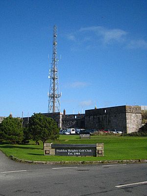
Staddon Position: A Strongpoint
Later Works: Modernizing the Defences
After the 1859 Royal Commission, Britain's dockyard defences were regularly checked and updated. As weapons improved and military strategies changed, new fortified batteries were built. Older ones were either made more modern or had their guns removed.
- Frobisher Battery (1888)
- Hawkins Battery (1888)
- Penlee Battery (1889)
- Raleigh Battery (1890)
- Whitesand Bay Battery (1889)
- Lord Howard's Battery (1909)
 | Chris Smalls |
 | Fred Hampton |
 | Ralph Abernathy |


