
Garfield Mountain (Washington) facts for kids
Quick facts for kids Garfield Mountain |
|
|---|---|

Garfield Mountain
|
|
| Highest point | |
| Elevation | 5,519 ft (1,682 m) |
| Prominence | 839 ft (256 m) |
| Geography | |

Garfield Mountain
Location in Washington (state)

Garfield Mountain
Location in the United States
|
|
| Location | King County, Washington state, U.S. |
| Parent range | Cascade Range |
| Topo map | USGS Snoqualmie Lake |
| Climbing | |
| First ascent | August 27, 1940 by Jim Crooks and Judson Nelson |
| Easiest route | Climbing |
Garfield Mountain, also known as Mount Garfield, is a mountain with several peaks located in King County, Washington state. It sits on the western edge of the Cascade Range and is part of the Alpine Lakes Wilderness. This land is managed by the Mount Baker-Snoqualmie National Forest. Mount Garfield is special because it rises very steeply from the land around it, even though it's not the tallest mountain. The mountain was named to honor James A. Garfield, who was the 20th President of the United States. Rain and melted snow from the mountain flow into smaller streams that feed into the Snoqualmie River.
Weather at Garfield Mountain
Garfield Mountain is in a place with a special kind of weather called a marine west coast climate. This means it gets a lot of rain and snow. Most weather systems start over the Pacific Ocean and move northeast towards the Cascade Mountains.
When these weather systems reach the mountains, the air is forced to rise. As the air goes higher, it cools down and drops its moisture as rain or snow onto the Cascades. This process is called orographic lift. Because it's close to the ocean, the snow here is often wet and heavy. This can lead to a high risk of avalanches.
During winter, the weather is usually cloudy. But in the summer, high-pressure systems over the Pacific Ocean often bring clear skies. The best time to visit or climb this mountain is usually from July through September, when the weather is most pleasant.
How the Mountains Formed
The Alpine Lakes Wilderness has some very rugged land. You can see sharp peaks, long ridges, deep valleys carved by glaciers, and tall granite walls. There are also more than 700 mountain lakes scattered around.
The amazing shapes of the Cascade Mountains were created by huge geological events that happened millions of years ago. These events caused big changes in elevation and led to different climates across the region. These climate differences then created various types of plant life in different ecoregions.
The Cascade Mountains began to form millions of years ago, during a time called the late Eocene Epoch. This happened because the North American Plate slowly moved over the Pacific Plate. This movement caused many volcanic eruptions and created new rock. Also, small pieces of the Earth's outer layer, called terranes, joined together to form the North Cascades about 50 million years ago.
Later, during the Pleistocene period (which started over two million years ago), glaciers grew and shrank many times. As they moved, they scraped and shaped the land, leaving behind piles of rock. The last time glaciers melted away from the Alpine Lakes area was about 14,000 years ago. By 10,000 years ago, they had moved north of the Canada–US border. The "U"-shaped valleys you see today were carved by these glaciers.
The powerful forces of uplift (when land is pushed up) and faulting (when cracks form in the Earth's crust) worked with the glaciers. Together, these processes created the tall peaks and deep valleys of the Alpine Lakes Wilderness.
Images for kids
-
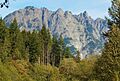
Garfield Mountain seen from the Middle Fork Snoqualmie River.
-
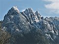
Mount Garfield in autumn.


