Grant County, South Dakota facts for kids
Quick facts for kids
Grant County
|
|
|---|---|

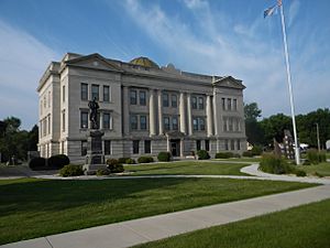
County Courthouse
|
|

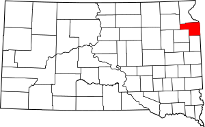
Location within the U.S. state of South Dakota
|
|
 South Dakota's location within the U.S. |
|
| Country | |
| State | |
| Founded | 1873 (created) January 8, 1878 (organized) |
| Named for | Ulysses S. Grant |
| Seat | Milbank |
| Largest city | Milbank |
| Area | |
| • Total | 688 sq mi (1,780 km2) |
| • Land | 681 sq mi (1,760 km2) |
| • Water | 6.1 sq mi (16 km2) 0.9% |
| Population
(2020)
|
|
| • Total | 7,556 |
| • Estimate
(2023)
|
7,553 |
| • Density | 10.983/sq mi (4.240/km2) |
| Time zone | UTC−6 (Central) |
| • Summer (DST) | UTC−5 (CDT) |
| Congressional district | At-large |
Grant County is a place in the state of South Dakota, United States. It's like a big neighborhood or district. In 2020, about 7,556 people lived here. The main town, or county seat, is Milbank.
Grant County was started in 1873 and officially organized in 1878. It is named after Ulysses S. Grant, who was the 18th President of the United States.
Contents
Geography
Grant County is on the eastern side of South Dakota. Its eastern border touches the state of Minnesota. The land here has rolling hills that gently slope towards the northeast. Most of the land is used for farming. The highest spot in the county is about 2,014 feet (614 meters) above sea level.
The total area of Grant County is about 688 square miles (1,782 square kilometers). Most of this, 681 square miles (1,764 square kilometers), is land. The rest, about 6.1 square miles (16 square kilometers), is water.
The lowest point in the entire state of South Dakota is found in Grant County. It's on Big Stone Lake near Big Stone City. This is where the lake flows into the Minnesota River.
Main Roads
 Interstate 29
 U.S. Route 12
 U.S. Route 81
 South Dakota Highway 15
 South Dakota Highway 20
 South Dakota Highway 109
 South Dakota Highway 123
 South Dakota Highway 158
Neighboring Counties
- Roberts County (north)
- Big Stone County, Minnesota (northeast)
- Lac qui Parle County, Minnesota (east)
- Deuel County (south)
- Codington County (southwest)
- Day County (west)
Nature Areas
- Mazeppa State Public Shooting Area
- Mud Lake State Public Shooting Area
Lakes in Grant County
- Big Stone Lake (next to the county)
- Crooked Lake
- LaBolt Lake
- Lake Albert
- Lake Farley
- Lonesome Lake (part of it)
- Mud Lake
- Myers Lake
- Summit Lake
- Twin Lakes
People and Population
| Historical population | |||
|---|---|---|---|
| Census | Pop. | %± | |
| 1880 | 3,010 | — | |
| 1890 | 6,814 | 126.4% | |
| 1900 | 9,103 | 33.6% | |
| 1910 | 10,303 | 13.2% | |
| 1920 | 10,880 | 5.6% | |
| 1930 | 10,729 | −1.4% | |
| 1940 | 10,552 | −1.6% | |
| 1950 | 10,233 | −3.0% | |
| 1960 | 9,913 | −3.1% | |
| 1970 | 9,005 | −9.2% | |
| 1980 | 9,013 | 0.1% | |
| 1990 | 8,372 | −7.1% | |
| 2000 | 7,847 | −6.3% | |
| 2010 | 7,356 | −6.3% | |
| 2020 | 7,556 | 2.7% | |
| 2023 (est.) | 7,553 | 2.7% | |
| U.S. Decennial Census 1790-1960 1900-1990 1990-2000 2010-2020 |
|||
2020 Population Count
In 2020, a count of the population (called a census) showed that 7,556 people lived in Grant County. There were 3,103 households, which are like homes where people live. About 2,014 of these were families.
2010 Population Count
In 2010, the census showed 7,356 people living in the county. There were 3,089 households. Most people were white (97.1%). Smaller groups included American Indian, Asian, and Black people. About 2.3% of the population was of Hispanic or Latino background.
Many people in Grant County have German (49.9%) or Norwegian (16.8%) family backgrounds. Other backgrounds include Irish, Swedish, and English.
Towns and Cities
Cities
- Big Stone City
- Milbank (This is the county seat, meaning it's the main town for the county government.)
Towns
Other Communities
- Troy (This is a small community not officially a city or town.)
Townships
- Adams
- Alban
- Big Stone
- Blooming Valley
- Farmington
- Georgia
- Grant Center
- Kilborn
- Lura
- Madison
- Mazeppa
- Melrose
- Osceola
- Stockholm
- Troy
- Twin Brooks
- Vernon
Schools
Here are some of the school districts that serve students in Grant County:
- Big Stone City School District 25-1
- Deuel School District 19-4
- Florence School District 14-1
- Milbank School District 25-4
- Summit School District 54-6
- Watertown School District 14-4
- Waubay School District 18-3
- Waverly School District 14-5
- Wilmot School District 54-7
See also
 In Spanish: Condado de Grant (Dakota del Sur) para niños
 | Kyle Baker |
 | Joseph Yoakum |
 | Laura Wheeler Waring |
 | Henry Ossawa Tanner |

