Guthrie County, Iowa facts for kids
Quick facts for kids
Guthrie County
|
|
|---|---|

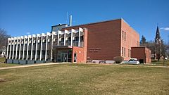
Guthrie County Courthouse
|
|

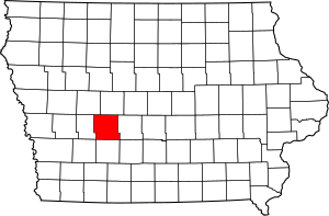
Location within the U.S. state of Iowa
|
|
 Iowa's location within the U.S. |
|
| Country | |
| State | |
| Founded | 1851 |
| Seat | Guthrie Center |
| Largest city | Guthrie Center |
| Area | |
| • Total | 593 sq mi (1,540 km2) |
| • Land | 591 sq mi (1,530 km2) |
| • Water | 2.5 sq mi (6 km2) 0.4% |
| Population
(2020)
|
|
| • Total | 10,623 |
| • Density | 17.914/sq mi (6.917/km2) |
| Time zone | UTC−6 (Central) |
| • Summer (DST) | UTC−5 (CDT) |
| Congressional district | 3rd |
Guthrie County is a special area of land, like a district, in the state of Iowa in the United States. It's a place where many people live and work.
In 2020, about 10,623 people lived here. The main town, or county seat, where the county government is located, is Guthrie Center. Guthrie County was created on January 15, 1851. It was named after Captain Edwin B. Guthrie, a brave soldier who died in the Mexican–American War.
Guthrie County is also part of a larger area called the Des Moines Metropolitan Statistical Area. This means it's connected to the bigger cities of Des Moines and West Des Moines.
Contents
Exploring Guthrie County's Land and Location
Guthrie County covers a total area of about 593 square miles. Most of this area, about 591 square miles, is land. The rest, about 2.5 square miles, is water. This means there are small lakes, rivers, or streams within the county.
Main Roads in Guthrie County
These are the important highways that help people travel through Guthrie County:
Neighboring Counties Around Guthrie County
Guthrie County shares its borders with several other counties:
- Greene County to the north
- Dallas County to the east
- Adair County to the south
- Audubon County to the west
- Carroll County to the northwest
Understanding Guthrie County's Population
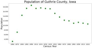
The number of people living in Guthrie County has changed over many years. Here's how the population has grown and changed since 1860:
| Historical population | |||
|---|---|---|---|
| Census | Pop. | %± | |
| 1860 | 3,058 | — | |
| 1870 | 7,061 | 130.9% | |
| 1880 | 14,394 | 103.9% | |
| 1890 | 17,380 | 20.7% | |
| 1900 | 18,729 | 7.8% | |
| 1910 | 17,374 | −7.2% | |
| 1920 | 17,596 | 1.3% | |
| 1930 | 17,324 | −1.5% | |
| 1940 | 17,210 | −0.7% | |
| 1950 | 15,197 | −11.7% | |
| 1960 | 13,607 | −10.5% | |
| 1970 | 12,243 | −10.0% | |
| 1980 | 11,983 | −2.1% | |
| 1990 | 10,935 | −8.7% | |
| 2000 | 11,353 | 3.8% | |
| 2010 | 10,954 | −3.5% | |
| 2020 | 10,623 | −3.0% | |
| 2023 (est.) | 10,722 | −2.1% | |
| U.S. Decennial Census 1790-1960 1900-1990 1990-2000 2010-2018 |
|||
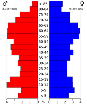
Population in 2020
The 2020 census counted 10,623 people in Guthrie County. This means there were about 18 people living in each square mile. Most people (91.86%) identified as non-Hispanic White.

Population in 2010
In 2010, the census recorded 10,954 people living in the county. There were 5,756 homes, and 4,544 of them were lived in.
Cities and Towns in Guthrie County
Guthrie County has several cities and towns where people live.
Cities
Townships
Townships are smaller areas of land within a county, often with their own local government.
- Baker Township
- Bear Grove Township
- Beaver Township
- Cass Township
- Dodge Township
- Grant Township
- Highland Township
- Jackson Township
- Orange Township
- Penn Township
- Richland Township
- Seely Township
- Stuart Township
- Thompson Township
- Union Township
- Valley Township
- Victory Township
Unincorporated Communities
These are smaller communities that are not officially part of a city or town.
Census-designated places
These are areas that are like towns but are only defined for census purposes.
- Diamondhead Lake
- Lake Panorama
How Communities Rank by Population
This table shows the population of the cities and towns in Guthrie County, based on the 2020 census. † This symbol means it is the county seat, the main town of the county.
| Rank | City/Town/etc. | Municipal type | Population (2020 Census) |
|---|---|---|---|
| 1 | † Guthrie Center | City | 1,593 |
| 2 | Lake Panorama | CDP | 1,266 |
| 3 | Panora | City | 1,091 |
| 4 | Stuart (partially in Adair County) | City | 1,059 (1,782 total) |
| 5 | Bayard | City | 405 |
| 6 | Diamondhead Lake | CDP | 371 |
| 7 | Casey (partially in Adair County) | City | 368 (387 total) |
| 8 | Menlo | City | 345 |
| 9 | Yale | City | 267 |
| 10 | Bagley | City | 233 |
| 11 | Jamaica | City | 195 |
| 12 | Adair (mostly in Adair County) | City | 18 (791 total) |
| 13 | Coon Rapids (mostly in Carroll County) | City | 0 (1,300 total) |
See also
 In Spanish: Condado de Guthrie para niños


