
Half Dome facts for kids
Quick facts for kids Half Dome |
|
|---|---|

Sunset over Half Dome from Glacier Point
|
|
| Highest point | |
| Elevation | 8846 ft (2696 m) NAVD 88 |
| Prominence | 1,360 ft (410 m) |
| Parent peak | Clouds Rest |
| Geography | |

Half Dome
Location in California
|
|
| Parent range | Sierra Nevada |
| Topo map | USGS Half Dome |
| Geology | |
| Age of rock | Cretaceous, 93 Myr |
| Mountain type | Granite dome |
| Climbing | |
| First ascent | 1875 by George G. Anderson |
| Easiest route | Cable route |
Half Dome is a famous granite dome located in Yosemite National Park, California. It stands at the eastern end of Yosemite Valley. This well-known rock formation gets its name from its unique shape. One side is a very steep, flat face, while the other three sides are smooth and rounded. This makes it look like a giant dome that has been cut in half. The granite peak rises more than 4,737 feet (1,444 meters) above the valley floor.
Contents
How Half Dome Was Formed

From the valley floor, Half Dome looks like a round dome that lost its northwest half. But this is actually an illusion! If you look at it from Washburn Point, Half Dome appears as a thin ridge of rock. This ridge is called an arête.
Its southeast side is almost as steep as its northwest side, except right at the very top. Most of the original dome's "half" may still be there. The way this ridge is shaped, along with Tenaya Canyon, is likely due to large cracks in the rock called joints.
Climbing to the Top

In the 1870s, people thought Half Dome was "perfectly inaccessible." But in October 1875, a man named George G. Anderson finally reached the top. He did this by drilling holes and placing iron eyebolts into the smooth granite to help him climb.
Today, thousands of hikers reach the summit each year. They follow an 8.5-mile (13.7 km) trail from the valley floor. The hike is very challenging. It includes a tough 2-mile (3.2 km) climb with many granite stairs.
The last part of the climb is up a steep, but somewhat rounded, east face. Hikers use a pair of steel cables to help them. These cables were first put up in 1919, close to Anderson's original route.
Besides hiking, there are also many rock climbing routes up Half Dome's vertical northwest face. The first technical climb happened in 1957. It was done by Royal Robbins, Mike Sherrick, and Jerry Gallwas. Their climb, called the Regular Northwest Face, took five days. It was the first "Grade VI" climb in the United States. Today, experienced climbers can do this route in just a few hours! Other climbing routes go up the south face and the west shoulder.
Hiking the Cable Route
The Half Dome Cable Route hike is 8.2 miles (13.2 km) long from the valley floor to the top. Hikers gain about 4,800 feet (1,463 meters) in elevation. This hike used to be less crowded because it is so long and difficult. However, in recent years, as many as 800 people hike it every day.
Many people do the hike in one long day. But some prefer to camp overnight in Little Yosemite Valley to break it up. The trail passes Vernal Fall and Nevada Fall. Then it continues into Little Yosemite Valley before heading north to the base of Half Dome.
The final 400 feet (122 meters) of the climb are very steep. Hikers use two steel cables as handholds. These cables are attached to the rock with bolts and raised onto metal poles. This usually happens in late May. The poles are taken down for the winter in early October. The cables are still attached to the rock, but it's much harder and more dangerous to use them when the poles are down. The National Park Service suggests not climbing the route when the cables are down or when the rock is wet and slippery. The Cable Route is rated class 3. This means it's a difficult hike that sometimes requires using your hands.

The Cable Route can get very crowded. In the past, up to 1,000 hikers climbed the dome on a summer weekend. About 50,000 hikers climb it every year.
Since 2011, all hikers who want to use the Cable Route must get a permit before they enter the park. Park rangers check these permits on the trail. Hikers without permits are not allowed to go past the base of the sub-dome or to the bottom of the cables. If hikers try to go around the rangers without a permit, they can face big fines or even jail time.
Backpackers who have a special wilderness permit can get a Half Dome permit when they pick up their wilderness permit. They don't need an extra reservation. Rock climbers who reach the top of Half Dome without using the sub-dome area can come down the Half Dome Trail without a permit.
The top of Half Dome is a large, flat area. Climbers can relax there and enjoy the amazing views. From the summit, you can see Little Yosemite Valley and the Valley Floor. A special spot near the top is called the "Diving Board." This is where famous photographer Ansel Adams took his picture Monolith, the Face of Half Dome in 1927. The Diving Board is on the shoulder of Half Dome, not to be confused with "the Visor," which is a small overhanging ledge at the summit.
Since the cables were put up in 1919, there have been seven fatal falls from them. The most recent one happened in 2019.
Lightning strikes can be dangerous on or near the summit. In 1985, five hikers were struck by lightning, and two of them died.
In 2012, the Cable Route was added to the National Register of Historic Places. This means it is recognized as an important historical site.
Fun Facts
The ashes of Ansel Adams were scattered on Half Dome. His photographs of Half Dome are very famous.
Half Dome in Culture

Half Dome was originally called "Tis-sa-ack" by the local Ahwahnechee people. This name means "Cleft Rock." Tis-sa-ack is also the name of a climbing route on the formation. It was climbed by Royal Robbins and Don Peterson in 1969.
In a native legend, Tis-sa-ack is the name of a mother. The face you can sometimes see in Half Dome is said to be hers. Other stories say the Ahwahneechee people named Half Dome "Face of a Young Woman Stained with Tears" ("Tis-se’-yak"). This is because of the brown-black lichens that form dark, vertical stripes on the rock faces, looking like tears.
In 1988, Half Dome was shown on a 25-cent United States postage stamp. An image of Half Dome, along with John Muir and the California condor, also appears on the California State Quarter. This quarter was released in January 2005.

Images for kids
-
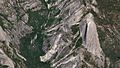
Half Dome and Yosemite, as seen from a SkySat satellite

See also
 In Spanish: Half Dome para niños
