Hampton Falls, New Hampshire facts for kids
Quick facts for kids
Hampton Falls, New Hampshire
|
||
|---|---|---|
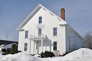
Town Hall
|
||
|
||
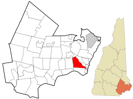
Location in Rockingham County and the state of New Hampshire
|
||
| Country | United States | |
| State | New Hampshire | |
| County | Rockingham | |
| Incorporated | 1726 | |
| Area | ||
| • Total | 12.7 sq mi (32.8 km2) | |
| • Land | 12.2 sq mi (31.7 km2) | |
| • Water | 0.4 sq mi (1.1 km2) 3.39% | |
| Elevation | 66 ft (20 m) | |
| Population
(2020)
|
||
| • Total | 2,403 | |
| • Density | 197/sq mi (75.9/km2) | |
| Time zone | UTC−5 (Eastern) | |
| • Summer (DST) | UTC−4 (Eastern) | |
| ZIP Code |
03844
|
|
| Area code(s) | 603 | |
| FIPS code | 33-33460 | |
| GNIS feature ID | 0873617 | |
Hampton Falls is a small town in Rockingham County, New Hampshire, United States. In 2020, about 2,403 people lived there. It's a quiet place with a rich history, once known for its farms and mills. Today, it's mostly a residential area.
Contents
Discovering Hampton Falls' Past
Archaeologists have found proof that people lived in what is now Hampton Falls for about 10,000 years! The first people here were indigenous peoples of the Northeastern Woodlands.
Early European Settlement and Growth
Europeans first settled this area in 1638. At that time, it was part of Hampton. In 1643, Hampton joined a larger area called Norfolk County, Massachusetts Colony. This county included other towns like Exeter and Portsmouth. However, in 1679, the towns in modern-day New Hampshire separated from the Massachusetts Bay Colony.
A church building might have been here as early as 1665. But it wasn't until 1709 that the area was officially called the Third Parish of Hampton. This parish included land that is now Seabrook, Kensington, and Hampton Falls.
Becoming an Independent Town
A meeting house (a place for town meetings and church services) was built soon after 1709. In 1711, many church members from Hampton joined the new church in the Third Parish. The first town meeting was held in 1718.
In 1726, the area officially became its own town, named "Hampton Falls." It was still sometimes called a parish until the American Revolutionary War. The town covers about 7,400 acres (30 square kilometers).
Changes to Town Borders
In 1732, there was an idea to separate the western part of Hampton Falls. This land did separate, but it didn't join Kingston as planned. Instead, in 1737, it became its own town called Kensington.
In 1765, some people in the southern part of Hampton Falls wanted to form a new parish. This led to the town being divided into two. The new parish was formed in 1768 and soon became the town of Seabrook. Around 1770, Hampton Falls was a leading manufacturing town in New Hampshire.
Notable Events and Disasters
In 1735 and 1736, a serious illness, now thought to be diphtheria, affected Hampton Falls. Many people, especially children, became sick. Sadly, 214 people in town passed away. The illness returned in 1754, but with fewer people affected.
On the night of October 29-30, 1827, an earthquake shook Hampton Falls. There was a flash of light, followed by strong shaking. Some chimneys fell down or cracked. A more powerful earthquake had hit the town earlier, on November 18, 1755.
More recently, on May 21, 2006, an F2 tornado touched down in Hampton Falls. It happened near Interstate 95. The tornado overturned a truck, injuring two people.
Exploring Hampton Falls' Geography
Hampton Falls is located about 45 miles (72 km) south of Boston. It is also 13 miles (21 km) north of Portsmouth.
The highest point in town is Great Hill, which is 246 feet (75 meters) above sea level. The town has a total area of about 12.7 square miles (32.8 square kilometers). Most of this is land, with a small part being water.
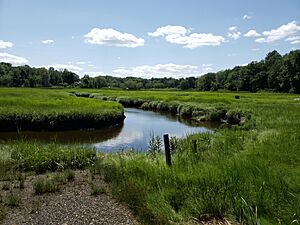
The Hampton Falls and Taylor rivers flow through the town. These rivers are part of the Hampton River system, which flows into the Atlantic Ocean. Hampton Falls also has nearly 1,000 acres (4 square kilometers) of beautiful salt marsh.
Nearby Towns and Cities
Hampton Falls shares its borders with several other towns:
- Hampton (to the northeast)
- Seabrook (to the south)
- Kensington (to the west)
- Exeter (to the northwest)
Understanding Hampton Falls' Population
| Historical population | |||
|---|---|---|---|
| Census | Pop. | %± | |
| 1790 | 541 | — | |
| 1800 | 519 | −4.1% | |
| 1810 | 570 | 9.8% | |
| 1820 | 572 | 0.4% | |
| 1830 | 582 | 1.7% | |
| 1840 | 656 | 12.7% | |
| 1850 | 640 | −2.4% | |
| 1860 | 621 | −3.0% | |
| 1870 | 679 | 9.3% | |
| 1880 | 678 | −0.1% | |
| 1890 | 623 | −8.1% | |
| 1900 | 560 | −10.1% | |
| 1910 | 552 | −1.4% | |
| 1920 | 483 | −12.5% | |
| 1930 | 481 | −0.4% | |
| 1940 | 493 | 2.5% | |
| 1950 | 629 | 27.6% | |
| 1960 | 885 | 40.7% | |
| 1970 | 1,254 | 41.7% | |
| 1980 | 1,372 | 9.4% | |
| 1990 | 1,467 | 6.9% | |
| 2000 | 1,890 | 28.8% | |
| 2010 | 2,236 | 18.3% | |
| 2020 | 2,403 | 7.5% | |
| Sources: | |||
The population of Hampton Falls has grown a lot over the years. In 1950, there were 629 residents. By 2000, this number had tripled to 1,880 people. This growth was faster than the average for the whole state of New Hampshire during some decades.
Hampton Falls' Economy and Jobs
Long ago, Hampton Falls was a community focused on farming and lumber. The many waterfalls on the Taylor River provided water power for mills. These mills helped the town's economy.
Today, Hampton Falls is mostly a place where people live. You can find many antique shops along U.S. 1. The largest employer in town is Applecrest Farm Orchards. This farm was started in 1913 and employs 18 people.
Learning in Hampton Falls: Schools
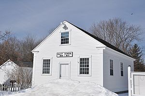
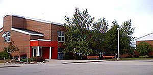
Hampton Falls currently has one public school, the Lincoln Akerman School. In the past, there were five public schools: the North, South, West, and two East schools. One of the East Schools burned down in 1947. The Lincoln Akerman School was built to replace it in 1949. While the new school was being built, students went to school in the nearby town of Seabrook.
High school students from Hampton Falls attend Winnacunnet High School. This school is located in the neighboring town of Hampton.
There is also a private middle school in town called Heronfield Academy. It is an Episcopal school located on Exeter Road.
Lincoln Akerman School: A Closer Look
The Lincoln H. Akerman School is for students from kindergarten through 8th grade. It was built in 1949. The school is named after Lincoln Akerman (1916–1942), who was a local hero during World War II.
Kindergarten was added to the school in 1993. Even though it's not required in New Hampshire, it's a great option for young learners.
In the mid-1990s, a famous author named Dan Brown taught Spanish here. He later wrote the best-selling book The Da Vinci Code.
In 2003, the Lincoln Akerman School was recognized for its high test scores. Students scored "significantly above the state average" in subjects like social studies, language arts, and math. The current principal is Beth Raucci, who started in 2018.
Famous Faces from Hampton Falls
Many interesting people have connections to Hampton Falls:
- Alice Brown (1856–1948), a writer of novels, poems, and plays.
- Maura Healey (born 1971), who became the Governor of Massachusetts.
- Scotty Lago (born 1987), an Olympic bronze medalist in snowboarding.
- Wesley Powell (1915–1981), who served as the Governor of New Hampshire.
- Florence Ryerson (1892–1965), a screenwriter who helped write The Wizard of Oz (1939 film).
- John H. Sununu (born 1939), who was the White House chief of staff and Governor of New Hampshire.
- Meshech Weare (1713–1786), the first president of New Hampshire.
- John Greenleaf Whittier (1807–1892), a famous poet and abolitionist.
See also
 In Spanish: Hampton Falls (Nuevo Hampshire) para niños
 | Shirley Ann Jackson |
 | Garett Morgan |
 | J. Ernest Wilkins Jr. |
 | Elijah McCoy |


