Harpswell, Maine facts for kids
Quick facts for kids
Harpswell, Maine
|
|
|---|---|

Lookout Point
|
|

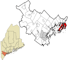
Location in Cumberland County and the state of Maine.
|
|
| Country | United States |
| State | Maine |
| County | Cumberland |
| Incorporated (district) | 1758 |
| Incorporated (town) | August 23, 1775 |
| Villages | Bailey Island Cundys Harbor Harpswell Center Dyer Cove East Harpswell North Harpswell Orrs Island South Harpswell West Harpswell |
| Area | |
| • Total | 127.69 sq mi (330.72 km2) |
| • Land | 24.18 sq mi (62.63 km2) |
| • Water | 103.51 sq mi (268.09 km2) |
| Elevation | 39 ft (12 m) |
| Population
(2020)
|
|
| • Total | 5,031 |
| • Density | 208/sq mi (80.3/km2) |
| Time zone | UTC-5 (Eastern (EST)) |
| • Summer (DST) | UTC-4 (EDT) |
| ZIP Codes | |
| Area code | 207 Exchange |
| FIPS code | 23-31390 |
| GNIS feature ID | 0582511 |
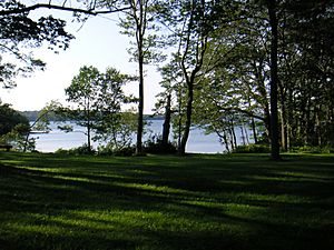
Harpswell is a charming town located in Cumberland County, Maine, in the United States. It sits right on Casco Bay, which is part of the Gulf of Maine in the Atlantic Ocean. In 2020, about 5,031 people lived there.
Harpswell is unique because it includes a mainland area called Harpswell Neck. It also has three large islands connected by bridges: Sebascodegan Island (also known as Great Island), Orr's Island, and Bailey Island. Plus, there are over 200 smaller islands! Harpswell is part of the larger Portland area.
| Top - 0-9 A B C D E F G H I J K L M N O P Q R S T U V W X Y Z |
Harpswell's Past: A Look at Its History
The first people to live in the Harpswell area were Abenaki Native Americans. They called Harpswell Neck Merriconeag, which means "quick carrying place." This name described how easy it was to carry boats across the narrow land. Great Island was known as Erascohegan or Sebascodiggin.
Around 1659, Major Nicholas Shapleigh bought these lands from the Abenaki. However, settlers faced challenges and left the area. They returned after a peace treaty in 1725.
Becoming a Town
Harpswell was once part of North Yarmouth. In 1758, it officially became its own town. It was named after Harpswell in England.
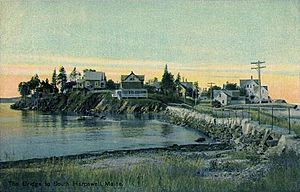
In the past, people in Harpswell mostly farmed and built ships. But fishing was very important and brought in a lot of money. Even today, catching lobster is a big part of the local economy. The famous Bailey Island Bridge is a special landmark. It is known for its unique design using granite slabs.
Where is Harpswell? Geography and Location
Harpswell covers a total area of about 127.69 square miles (330.72 square kilometers). Most of this area, about 103.51 square miles (268.09 square kilometers), is water. The land area is about 24.18 square miles (62.63 square kilometers).
The town is located on Casco Bay, which is part of the Gulf of Maine in the Atlantic Ocean. Harpswell has a very long coastline, stretching about 216 miles (348 kilometers).
Nearby Towns and Roads
Two main roads, Route 24 and Route 123, run through the town. Harpswell is next to Brunswick to the north. The New Meadows River separates it from West Bath to the northeast and Phippsburg to the east.
Who Lives in Harpswell? Population Facts
| Historical population | |||
|---|---|---|---|
| Census | Pop. | %± | |
| 1790 | 1,071 | — | |
| 1800 | 1,049 | −2.1% | |
| 1810 | 1,190 | 13.4% | |
| 1820 | 1,253 | 5.3% | |
| 1830 | 1,352 | 7.9% | |
| 1840 | 1,448 | 7.1% | |
| 1850 | 1,534 | 5.9% | |
| 1860 | 1,603 | 4.5% | |
| 1870 | 1,749 | 9.1% | |
| 1880 | 1,773 | 1.4% | |
| 1890 | 1,766 | −0.4% | |
| 1900 | 1,750 | −0.9% | |
| 1910 | 1,650 | −5.7% | |
| 1920 | 1,242 | −24.7% | |
| 1930 | 1,364 | 9.8% | |
| 1940 | 1,305 | −4.3% | |
| 1950 | 1,644 | 26.0% | |
| 1960 | 2,032 | 23.6% | |
| 1970 | 2,552 | 25.6% | |
| 1980 | 3,796 | 48.7% | |
| 1990 | 5,012 | 32.0% | |
| 2000 | 5,239 | 4.5% | |
| 2010 | 4,740 | −9.5% | |
| 2020 | 5,031 | 6.1% | |
| U.S. Decennial Census | |||
Population in 2010
In 2010, there were 4,740 people living in Harpswell. They lived in 2,218 homes, with 1,450 of these being families. The town had about 196 people per square mile.
Most residents (97.7%) were White. A small number were from other racial backgrounds. About 0.8% of the population was Hispanic or Latino.
Around 19.1% of homes had children under 18. Most homes (55.3%) were married couples. The average age in Harpswell was 52.9 years old. About 15% of residents were under 18. Many residents (25.9%) were 65 years or older.
Emergency Services in Harpswell
Harpswell has three volunteer fire departments that help keep the town safe. These departments also provide emergency medical services (EMS) and operate ambulances. A paramedic is always on duty at the town hall to help with medical emergencies.
- Harpswell Neck Fire Department
- Orr's and Bailey Island Fire Department
- Cundy's Harbor Fire Department
The Cumberland County Sheriff's Office provides law enforcement services for Harpswell.
Learning in Harpswell: Schools and Education
Public schools in Harpswell are part of Maine School Administrative District 75. In 2011, residents decided to close West Harpswell School. Students from there now attend Harpswell Islands School. This change helped the town save money.
In 2013, a new school called Harpswell Coastal Academy opened. It is a charter school for students in grades 6 through 12. It is located in the old West Harpswell School building.
There is also a private preschool called the Harpswell Nature School. It started in 2003 and helps young children learn about nature.
Famous People from Harpswell
Many interesting people have connections to Harpswell, including:
- John Chryssavgis, an author and theologian
- Patrick Dempsey, a well-known actor
- Stephen M. Etnier, an artist
- Elijah Kellogg, a minister and author
- Edna St. Vincent Millay, a famous poet
- Robert Peary, a famous explorer
Places to Visit in Harpswell
Harpswell has several interesting places to explore:
- Eagle Island State Historic Site – This was the summer home of Admiral Robert Peary, the Arctic explorer.
- Harpswell Historical Society Museum – Learn about the town's past here.
- Harpswell Cattle Pound – This old structure was used to hold stray animals.
- Ragged Island – This island was the summer home of poet Edna St. Vincent Millay.
- Bailey Island Cribstone Bridge – A unique bridge made of granite slabs, a true engineering marvel.
See also
 In Spanish: Harpswell (Maine) para niños
 | Isaac Myers |
 | D. Hamilton Jackson |
 | A. Philip Randolph |


